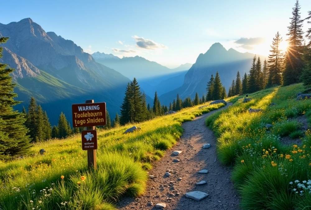
There’s a fine line between adventure and insanity, and some trails blur it completely. These aren’t your average nature walks—every step is a gamble, every turn a test of nerve.
Sheer cliffs, relentless heat, wild weather, and trails are so dangerous they’ve claimed lives. Yet, thrill-seekers can’t resist. Why? Because danger makes the view sweeter, the journey unforgettable, and the victory legendary.
If your idea of hiking involves pushing limits, facing fears, and standing where few dare, you’re in for a ride. But beware—these trails don’t forgive mistakes. Are you ready to see the most dangerous hikes in America?
1. The Maze – Canyonlands National Park, Utah
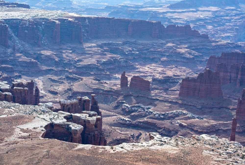
If you like your hikes with a side of absolute disorientation, The Maze in Canyonlands National Park might be your dream (or nightmare) destination. This trail isn’t just about rugged terrain—it’s a labyrinth of dead-end canyons, sheer drops, and mind-boggling route-finding challenges. The name isn’t for show; even seasoned hikers can get lost here, with very few trail markers to guide you back to safety.
The real danger? You’re completely on your own. There’s little to no cell service, and rescues take hours if not days. Water sources are scarce, and the summer heat can push temps into triple digits. If you’re not an expert in navigation and survival skills, this place can turn deadly fast. Even experienced hikers carry satellite GPS devices and weeks’ worth of supplies.
But for those who dare, the reward is otherworldly solitude. Towering sandstone formations, slot canyons, and an eerie silence make The Maze an unforgettable challenge. Just make sure your map-reading skills are as sharp as your sense of adventure.
Quick Facts & Important Info:
- Best months to visit: Spring (March-May) and Fall (September-November)
- Major risks: Getting lost, dehydration, extreme heat, lack of rescue options
- Permits required? Yes, backcountry permits are required
- How long does it take? Multi-day trek (2-7 days, depending on route)
- Nearest help? Several hours away—self-sufficiency is a must
2. Mount Washington – New Hampshire
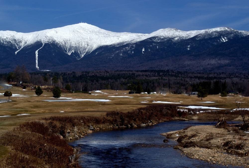
At first glance, Mount Washington doesn’t look too intimidating. Standing at 6,288 feet, it’s no Everest. But don’t be fooled—this mountain holds the title for some of the worst weather in the world. Wind speeds here have hit a record 231 mph, and in winter, the wind chill can make temperatures feel like -50°F.
Hikers often underestimate the sudden weather changes, going from sunshine to blizzards in a matter of minutes. The mountain is infamous for claiming over 150 lives due to hypothermia, falls, and exhaustion. Even in summer, temperatures can drop below freezing, and fog so thick you can barely see your own hands can roll in out of nowhere.
Yet, Mount Washington remains a magnet for thrill-seekers. The views are jaw-dropping, and the challenge? Legendary. If you go, pack for winter, even in July, and don’t be afraid to turn back. The mountain will still be there tomorrow—you need to make sure you are, too.
Quick Facts & Important Info:
- Best months to visit: June-September (but always check the weather!)
- Major risks: Hypothermia, extreme winds, unpredictable weather
- Permits required? No, but always notify someone of your route
- How long does it take? 6-10 hours round trip, depending on conditions
- Nearest help? Mount Washington Observatory & Ranger Station
3. Angel’s Landing – Zion National Park, Utah
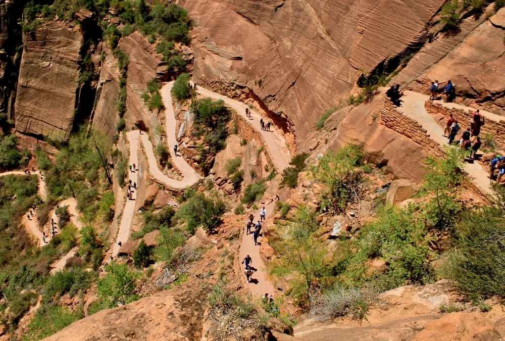
This trail is not for the faint of heart—or those afraid of heights. Angel’s Landing is famous for its narrow ridgeline, dizzying drop-offs, and a final ascent where one wrong step could send you plummeting 1,000 feet to your doom.
The last half-mile is what makes this trail infamous. Hikers clutch onto a single chain bolted into the rock as they inch forward on a ridge just a few feet wide, with sheer cliffs on both sides. One gust of wind or a misstep can be fatal, and unfortunately, it has been for several hikers over the years. Zion National Park has even introduced a permit system to control the number of hikers attempting the climb.
That being said, the view from the top is breathtaking. Looking out over Zion Canyon, with its red rock cliffs and winding river, you’ll understand why so many people take the risk. Just make sure you’ve got sturdy shoes, a good grip, and nerves of steel.
Quick Facts & Important Info:
- Best months to visit: March-May, September-November (avoid summer crowds)
- Major risks: Falling, overcrowding, heat exhaustion
- Permits required? Yes, a new lottery permit system is in place
- How long does it take? 4-5 hours round trip
- Nearest help? Zion National Park Visitor Center
4. Bright Angel Trail – Grand Canyon, Arizona

The Bright Angel Trail seems welcoming at first—it’s well-maintained, heavily trafficked, and offers stunning views of the Grand Canyon. But don’t let that fool you. The hike is a grueling descent into the canyon, which means the real challenge comes when you have to hike back up.
The biggest danger? Heat and exhaustion. The Grand Canyon is a natural oven, with temperatures inside soaring 20-30 degrees hotter than the rim. Many hikers underestimate the brutal uphill return, leading to dehydration, heatstroke, and even death. The National Park Service rescues hundreds of hikers from Bright Angel each year.
If you’re prepared, it’s one of the most scenic trails in the world. Just don’t try to hike down and back in one day unless you’re exceptionally fit—many have tried, and many have needed helicopter rescues.
Quick Facts & Important Info:
- Best months to visit: Spring (March-May) and Fall (September-November)
- Major risks: Dehydration, heat exhaustion, overexertion
- Permits required? Only for overnight camping
- How long does it take? 6-9 hours round trip to Plateau Point
- Nearest help? Phantom Ranch (if you’re lucky)
5. Half Dome – Yosemite National Park, California

Half Dome is one of the most iconic yet deadly hikes in the U.S. The final push to the summit involves climbing steel cables up a near-vertical rock face, where one slip could send you tumbling hundreds of feet to your death.
The cables section is terrifying, especially when wet. Since permits are now required, you can’t just show up and attempt it. Lightning storms are another killer, as the exposed summit has claimed several hikers caught in sudden storms.
If you do make it to the top, the view is surreal. Yosemite Valley stretches out below, and the sheer scale of the wilderness is humbling. But getting down is just as tough—your legs will be shaking, your arms will be sore, and you’ll be questioning your life choices the entire time.
Quick Facts & Important Info:
- Best months to visit: June-September (when cables are up)
- Major risks: Slipping on cables, exhaustion, lightning strikes
- Permits required? Yes, very limited
- How long does it take? 10-14 hours round trip
- Nearest help? Yosemite National Park Rangers
6. Kalalau Trail – Na Pali Coast, Hawaii
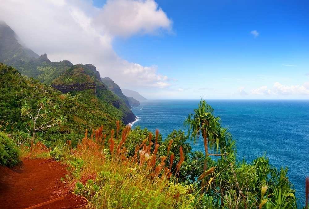
Tropical paradise? Yes. One of the most dangerous hikes in the U.S.? Absolutely. The Kalalau Trail is a stunning yet treacherous 11-mile trek along Hawaii’s Na Pali Coast, where sheer cliffs drop straight into the ocean, and flash floods can turn the trail into a death trap in minutes.
This isn’t your typical beachside stroll. Hikers must navigate muddy, slippery paths, unstable terrain, and “Crawler’s Ledge”—a terrifyingly narrow section with a deadly drop on one side and nothing to hold onto. And if that’s not enough, the unpredictable Hawaiian weather can change instantly, making river crossings impassable and stranding hikers for days.
But if you make it to Kalalau Beach, it’s pure magic. Towering cliffs, turquoise waters, and lush greenery make this one of the most beautiful places on Earth. Just be prepared—it’s a one-way-in, one-way-out kind of deal. There’s no easy rescue here.
Quick Facts & Important Info:
- Best months to visit: May-September (avoid rainy season)
- Major risks: Flash floods, falling, dehydration
- Permits required? Yes, strictly enforced
- How long does it take? 2 days round trip
- Nearest help? None—evacuations require a helicopter
7. Capitol Peak Knife Edge – Colorado
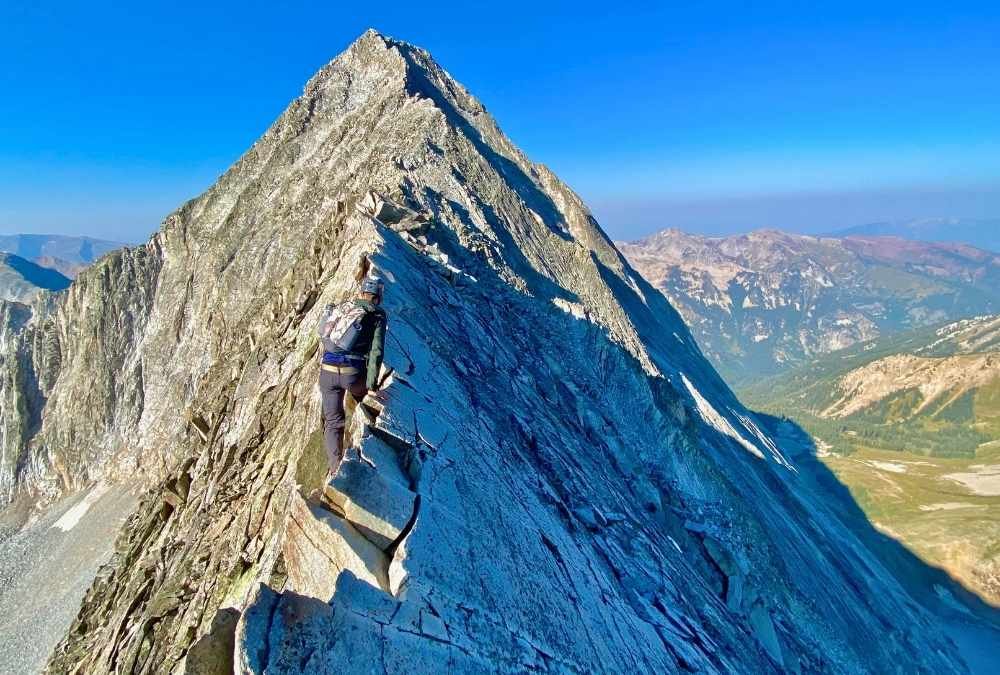
If your idea of fun is walking on a knife’s edge with sheer drops on both sides, welcome to Capitol Peak. This Colorado 14er is widely considered one of the most dangerous climbs in the Rockies, thanks to its infamous “Knife Edge”—a narrow, exposed ridge with a no-fall zone.
The problem? There’s no easy way around it. You have to straddle the ridge and inch your way across, hoping the wind doesn’t pick up. And even before you get there, the approach involves loose rock, cliffs, and high-altitude exposure. Many experienced climbers have miscalculated a step—and never made it back.
But the reward? A jaw-dropping summit view that makes you feel like you’ve conquered the world. Just don’t let your adrenaline get the best of you on the way down—most accidents happen during descent.
Quick Facts & Important Info:
- Best months to visit: July-September (when the snow is gone)
- Major risks: Falling, altitude sickness, rockslides
- Permits required? No, but experience is a must
- How long does it take? 12+ hours round trip
- Nearest help? Hours away—rescue is extremely difficult
8. Huckleberry Mountain – Glacier National Park, Montana
This isn’t just a hike—it’s a test of nerve. While the actual trail isn’t too technical, Huckleberry Mountain is known for its high concentration of grizzly bears. If you’re hiking here, bear spray isn’t optional—it’s survival gear.
The trail winds through dense bear country, meaning you’re never really alone. Sightings are common, and some hikers have had to turn back after coming face-to-face with a massive grizzly. Even if you’re not worried about wildlife, the elevation gain and sudden weather shifts can make this hike physically brutal.
That said, the summit views are unreal. You’ll get panoramic sights of Glacier National Park’s endless mountains, forests, and pristine wilderness. But as stunning as it is, you’ll probably breathe easier once you’re back at your car—and in one piece.
Quick Facts & Important Info:
- Best months to visit: June-September
- Major risks: Grizzly bears, weather changes, remoteness
- Permits required? No, but park rules apply
- How long does it take? 6-8 hours round trip
- Nearest help? Many miles away—bring emergency gear
9. Barr Trail – Pikes Peak, Colorado
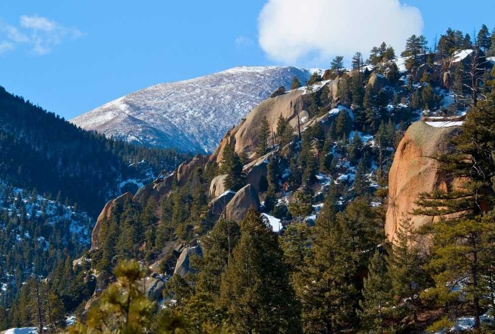
At 13 miles one way with over 7,400 feet of elevation gain, Barr Trail is an endurance challenge in disguise. It doesn’t have the sheer cliffs of Capitol Peak or the disorientation of The Maze, but what it does have is thin air, unpredictable storms, and exhaustion waiting to crush you.
Many hikers underestimate altitude sickness, which can hit hard as you climb toward Pikes Peak’s 14,115-foot summit. The weather is equally unforgiving—blue skies can turn into violent lightning storms within minutes. If you don’t time your ascent right, you might find yourself dodging lightning strikes above the tree line.
For those who persevere, reaching the summit is a badge of honor. And unlike most brutal hikes, this one has a unique perk: you can take the cog railway or drive down instead of hiking back. Not a bad reward for a grueling climb!
Quick Facts & Important Info:
- Best months to visit: June-September
- Major risks: Altitude sickness, exhaustion, lightning storms
- Permits required? No, but check weather conditions
- How long does it take? 6-10 hours up, 3-5 hours down
- Nearest help? Summit Visitor Center
10. Mount Huashan Plank Walk (Unofficial) – California
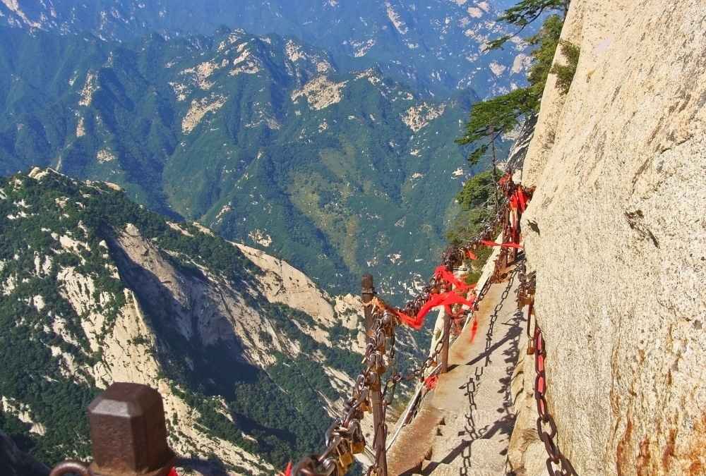
Wait, isn’t Mount Huashan in China? Yes, the famous plank walk is in China, but there’s an unofficial version in California. Hidden in the San Gabriel Mountains, a secret and highly illegal plank walk exists, built by daredevil hikers who wanted their version of the world’s most dangerous walk.
It consists of wooden planks bolted into a sheer rock face, with makeshift chains to hold onto. The whole thing is held together with hope, rust, and questionable DIY skills. There’s no rescue team, no official path, and absolutely zero margin for error.
If you attempt it (which you absolutely shouldn’t), you’re risking your life for an adrenaline rush. It’s illegal, it’s stupidly dangerous, and yet, thrill-seekers can’t seem to resist.
Quick Facts & Important Info:
- Best months to visit: Never—it’s illegal and unsafe
- Major risks: Falling to death, illegal trespassing, zero safety measures
- Permits required? Not applicable—it’s not an official trail
- How long does it take? Don’t find out
- Nearest help? Nowhere—this is a rescue team’s worst nightmare