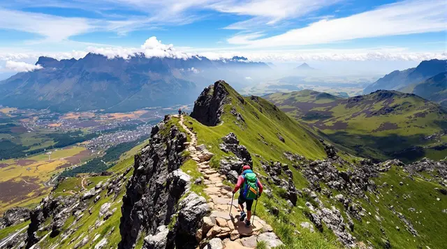
Standing at the edge of a cliff, your heart races as you look down at a drop that feels endless. The wind howls around you, each step testing your will to keep going. These hikes aren’t just about the challenge—they push your body, mind, and spirit to the edge.
For those seeking the ultimate adrenaline rush, some trails demand everything you’ve got, offering not just danger, but a sense of accomplishment that’s hard to find elsewhere. Ready for an adventure that will leave you breathless? Let’s dive into the most daring hikes on the planet.
1. Mount Huashan, China

If you’re an adrenaline junkie, Mount Huashan might just be the hike of your dreams—or your worst nightmare, depending on how you look at it! Known for its precarious paths clinging to the side of cliffs, this hike is notorious for its high altitude, sheer drops, and heart-stopping bridges. The mountain itself is one of China’s Five Great Mountains, and it offers stunning views, but reaching the peak is no easy feat. The most nerve-wracking part? The plank walk that seems like it belongs in an action movie. You’re strapped into a harness while you walk on a wooden plank that’s bolted to a vertical cliff. Sounds fun, right?
What makes Mount Huashan stand out is its combination of natural beauty and intense challenge. Despite its danger, the hike has been drawing people for centuries. The pathways are narrow, sometimes just wide enough for your feet to slip if you’re not careful. Be prepared to feel the sting of vertigo as you walk on ledges with nothing but thin air beneath you. The challenge is made all the more intense by the fact that the mountain is packed with temples and shrines, adding a spiritual element to the experience.
While the dangers are real, the thrill of completing this hike makes it one of the most exhilarating experiences out there. But remember, it’s not for the faint of heart. If you’re considering taking on Mount Huashan, take the time to prep physically and mentally for the challenge. Every step could be your last, but it’s worth the view.
Relevant Information:
- Best Months to Visit: April to October (Avoid winter due to icy conditions)
- Difficulty: Very difficult, with steep climbs and high-altitude risks
- Duration: 6 to 8 hours depending on route
- Distance: 12-15 kilometers
- What to Expect: Narrow ledges, cliffs, vertigo-inducing plank walks
- Safety Gear: Bring sturdy boots, gloves, and a harness if planning to do the plank walk
2. El Caminito del Rey, Spain
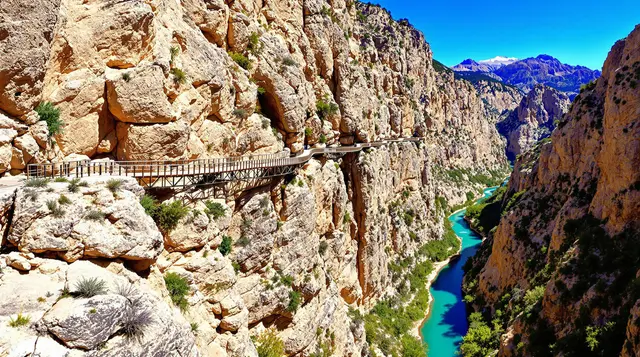
Once called “The Death Path,” El Caminito del Rey in Spain has had a remarkable transformation over the years. What was once a crumbling, dangerous pathway suspended high above a gorge is now a highly regulated, partially restored trail for the daring hiker. Although the path is no longer the treacherous death trap it once was, it still retains an edge of danger—especially for those with a fear of heights. The route spans over 3 kilometers and hangs precariously over the El Chorro gorge, offering unparalleled views of the dramatic surroundings.
Walking along this pathway, you’ll find yourself staring down at the rocky gorge below, with the path itself clinging to the cliffs. The combination of thin steel walkways, high suspensions, and sheer cliffs make this one of the most exhilarating hikes in the world. But don’t let the views fool you—the path is narrow, and it’s only for those who are comfortable with heights. One misstep, and you could end up several hundred feet below. The new safety rails make it a little less intense than it once was, but it’s still a thrill.
Despite the renovations, El Caminito del Rey is a hike that should be approached with caution. The entire trail has been revitalized to make it safer, but it remains a nerve-wracking adventure for those who love extreme experiences. It’s one of those hikes that’ll have you questioning your sanity halfway through, but when you finish, you’ll feel like you’ve conquered something truly legendary.
Relevant Information:
- Best Months to Visit: March to May or September to November (Avoid the summer heat)
- Difficulty: Medium to high
- Duration: 3 to 4 hours
- Distance: 3 kilometers
- What to Expect: Narrow walkways, cliffs, stunning canyon views
- Safety Gear: Closed shoes and a helmet (helmet provided on-site)
3. The Stairway to Heaven, Hawaii, USA
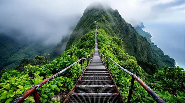
Let’s talk about the Stairway to Heaven—sounds mystical, right? This hike, also known as the Haiku Stairs, is one of the most legendary (and illegal) hikes in the United States. Located in Oahu, Hawaii, this trail used to be a military route before it was closed to the public. Despite the restrictions, many adventurers still find their way to the base of the stairs, ready to climb the nearly 4,000 steps that lead to the top of a mountain ridge. The hike itself is incredibly steep, with some steps measuring nearly 18 inches high. If you’re not used to climbing, it’ll certainly test your endurance.
What makes this hike so dangerous isn’t just the steepness—it’s also the weather. As you ascend, you’re often surrounded by mist and fog, which reduces visibility and makes the already-difficult path even more hazardous. Plus, the stairway itself is old and deteriorating, so you’ll have to watch every step. The views from the top, however, are worth it—when the clouds clear, you can see the entire island and its lush green mountains, and even the Pacific Ocean in the distance.
However, be warned: If you’re caught hiking this trail, you could face hefty fines. Despite its risk and the potential legal consequences, the Stairway to Heaven remains a bucket-list hike for thrill-seekers. But if you choose to do it, be sure to go with a group, and take extra care on the unstable, wet steps.
Relevant Information:
- Best Months to Visit: April to October (Dry season)
- Difficulty: Very high, steep with hazardous steps
- Duration: 4 to 6 hours
- Distance: 3.7 kilometers (one way)
- What to Expect: Steep climb, narrow steps, potential for fog and rain
- Safety Gear: Wear sturdy boots and bring gloves
4. Mount Everest, Nepal/Tibet
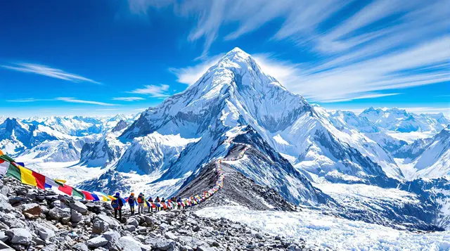
Mount Everest, the tallest mountain on Earth, is not just dangerous—it’s infamous for its high-altitude challenges and extreme conditions. Climbing the mountain, which stands at 8,848 meters above sea level, is an undertaking that requires extensive preparation, both physically and mentally. The thin air at such high altitudes can make each breath feel like a struggle, and the risk of altitude sickness is very real. Beyond that, climbers have to deal with extreme weather, avalanches, and treacherous icefalls.
One of the most dangerous parts of climbing Everest is the “Death Zone,” which refers to altitudes above 8,000 meters where the human body begins to break down due to a lack of oxygen. Even with supplemental oxygen, climbers face life-threatening risks such as frostbite, dehydration, and exhaustion. The sheer number of climbers also increases the risk of accidents, as bottlenecks in narrow sections can result in dangerous delays. Despite these challenges, summiting Everest remains a dream for many mountaineers.
If you’re planning to tackle Everest, be prepared for a multi-week journey, and don’t underestimate the dangers. You’ll need a guide, proper gear, and most importantly, an understanding of your own physical limits. It’s not a hike—it’s an expedition, and it’s one of the most deadly but awe-inspiring feats in the world.
Relevant Information:
- Best Months to Visit: April to May (Pre-monsoon season)
- Difficulty: Extremely high, requires prior mountaineering experience
- Duration: 2 months (depending on route and acclimatization)
- Distance: Varies, but the climb itself is over 60 kilometers round-trip
- What to Expect: Extreme altitude, freezing temperatures, challenging conditions
- Safety Gear: Oxygen tanks, climbing gear, cold-weather clothing
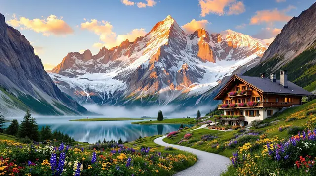
5. Mount Fitz Roy, Argentina

Mount Fitz Roy, also known as Cerro Chaltén, is an iconic peak in Patagonia, Argentina. It’s known for its rugged beauty and challenging terrain. The hike to its base is considered one of the most difficult, due to the combination of steep ascents, unpredictable weather, and the sheer remoteness of the area. The trail itself is about 20 kilometers long and features various landscapes, from dense forests to rocky outcrops, all while giving you stunning views of the jagged peak that towers above you.
What makes this hike particularly dangerous is the fact that the weather in Patagonia is notoriously volatile. In a single day, you can experience sunshine, rain, and snow, all while battling high winds that can make hiking nearly impossible. The sheer granite cliffs of Fitz Roy also attract climbers from all over the world who are looking to summit, but for most, it remains an elusive challenge.
Climbing Mount Fitz Roy is not something you take lightly. The altitude, terrain, and unpredictable weather conditions make it one of the most hazardous hikes in the world. But if you’re up for the challenge and prepared for whatever nature throws your way, the experience of standing at the base of one of the world’s most beautiful peaks is unforgettable.
Relevant Information:
- Best Months to Visit: November to March (Patagonia summer)
- Difficulty: High, requiring experience and endurance
- Duration: 2 to 3 days
- Distance: 20 kilometers
- What to Expect: Extreme weather, steep climbs, rocky terrain
- Safety Gear: Warm clothing, windproof gear, trekking poles
6. The Drakensberg Traverse, South Africa
The Drakensberg Mountains are known for their dramatic beauty and extreme conditions, making the Drakensberg Traverse one of the most dangerous and challenging hikes in South Africa. The trail spans over 200 kilometers and takes hikers through some of the highest peaks in the country. Steep climbs, rocky ridges, and unpredictable weather can make the hike treacherous. The allure of the Drakensberg, however, is undeniable: hikers are rewarded with stunning views of rugged cliffs, waterfalls, and sweeping valleys.
The hike itself is strenuous and requires experienced hikers, as it involves traversing not only the steep mountain ridges but also crossing rivers, dealing with potential snow, and occasionally climbing over boulders. The weather in the Drakensberg can change quickly, and the cold winds combined with the altitude make it feel even harsher. Some sections of the trail are exposed to high winds and can be slippery after rain, so you’ll need to be prepared for the elements at all times.
If you plan on hiking the Drakensberg Traverse, it’s essential to bring enough gear to handle the extreme conditions. This hike is often done in sections over several days, so it’s important to have a good map, sufficient supplies, and proper navigation skills. If you’re someone who loves a challenge and doesn’t mind the danger, the Drakensberg offers one of the most rewarding hiking experiences in the world.
Relevant Information:
- Best Months to Visit: November to March (summer months)
- Difficulty: High, requires experience and stamina
- Duration: 8-12 days (depending on pace and route)
- Distance: 200+ kilometers
- What to Expect: Rocky terrain, high winds, steep ascents
- Safety Gear: Waterproof clothing, trekking poles, and a compass
7. The Lost City Trail, Colombia
Hidden deep in the jungles of Colombia, the Lost City Trail (or Ciudad Perdida) takes hikers on a multi-day trek through dense rainforest, crossing rivers and muddy trails, all the way to the ancient Lost City of the Tairona people. The hike is dangerous due to the terrain, tropical diseases, and the presence of wildlife like snakes and jaguars. While it’s an incredibly popular trek, it’s not for the faint of heart. The journey can be grueling, with humid conditions, steep ascents, and treacherous paths.
What makes this hike so special—and dangerous—is the combination of the intense physical challenge and the historical significance. The trek ends at the Lost City, a hidden archaeological wonder that predates Machu Picchu. Along the way, you’ll be greeted by lush jungle, beautiful waterfalls, and incredible wildlife. But as you get deeper into the wilderness, the risks increase, from the possible danger of flooding to getting lost in the thick jungle.
Trekking through the Lost City is not only a test of your physical endurance but also your mental toughness. The hike is hot, exhausting, and risky, but the reward of reaching the Lost City is unparalleled. If you’re into adventure, history, and a touch of danger, this hike offers an experience you won’t soon forget.
Relevant Information:
- Best Months to Visit: December to March (dry season)
- Difficulty: High, requires fitness and jungle trekking experience
- Duration: 4 to 6 days
- Distance: 44 kilometers round-trip
- What to Expect: Hot, humid conditions, river crossings, dense jungle
- Safety Gear: Bug repellant, long pants, trekking poles, and a guide
8. Angel’s Landing, Zion National Park, USA
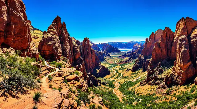
One of the most famous hikes in the U.S., Angel’s Landing in Zion National Park offers some of the most dramatic views in the world. However, it’s also one of the deadliest hikes in the country. The trail itself is only 5 miles round-trip, but it’s steep, with long stretches where you’re climbing up rocky ridges with drop-offs on both sides. The final section of the hike requires scrambling along a narrow ridge with chains to hold onto. One wrong move, and you could fall hundreds of feet.
What makes Angel’s Landing so dangerous is the narrowness of the trail and the sheer drop-offs that loom on either side. The final section, in particular, is infamous for its cliffs and high winds that can make even experienced hikers feel vulnerable. However, despite the dangers, Angel’s Landing remains a bucket-list hike because of its unmatched views at the summit. You’ll be rewarded with panoramic views of Zion Canyon, with its red sandstone cliffs stretching as far as the eye can see.
While the hike is dangerous, it’s also incredibly rewarding. If you’re physically fit and not afraid of heights, this trail offers a thrill like no other. But remember, this is a hike where you need to be focused and take your time. Safety is paramount, so be cautious and prepared for the rugged terrain.
Relevant Information:
- Best Months to Visit: March to May or September to November (Avoid the summer heat)
- Difficulty: High, with steep climbs and narrow ridges
- Duration: 4 to 5 hours
- Distance: 5 miles round-trip
- What to Expect: Cliffs, narrow ridges, chains for support
- Safety Gear: Good hiking shoes, gloves, and plenty of water
9. Mont Blanc, France/Italy/Switzerland
Mont Blanc, the highest peak in the Alps, is a favorite among climbers and a serious challenge for hikers. The trek to the summit (if you choose to attempt it) involves traversing glaciers, narrow ridges, and unpredictable weather conditions. While some routes are accessible to experienced hikers, the conditions on Mont Blanc are often extreme, with storms that can roll in without warning. The high-altitude environment and the technical skills required make this one of the most dangerous hikes in the world.
What makes Mont Blanc so hazardous isn’t just its altitude—at 4,810 meters above sea level—it’s the ever-changing weather and difficult terrain. The route can be incredibly slippery, especially in the higher parts of the mountain. Glacier crossings, steep ice slopes, and rock climbing make it an incredibly difficult climb for even seasoned hikers. You’ll also need to deal with the risk of altitude sickness, which can hit even the fittest adventurers at such high elevations.
Despite the risks, Mont Blanc is a popular destination for those looking to challenge themselves. If you decide to take on Mont Blanc, it’s crucial to have prior mountaineering experience and the right equipment, including ice axes and crampons. The payoff, however, is the opportunity to stand atop one of the world’s most iconic peaks.
Relevant Information:
- Best Months to Visit: June to September (summer)
- Difficulty: Extremely high, requires mountaineering experience
- Duration: 7 to 10 days (depending on route)
- Distance: 170 kilometers for the entire tour (varies by route)
- What to Expect: Glaciers, ice climbing, high-altitude weather conditions
- Safety Gear: Ice axes, crampons, mountaineering boots, and plenty of layers
10. The White Mountains, New Hampshire, USA
The White Mountains in New Hampshire offer some of the most dangerous hikes in the United States, particularly due to their unpredictable weather. The Mount Washington summit, one of the most popular in the range, is known for having some of the worst weather on the planet. With winds regularly exceeding 100 mph and temperatures plummeting to below freezing, hiking here is a serious challenge even in the summer months. The rugged terrain and high winds make it one of the most dangerous hikes in the U.S.
Hiking in the White Mountains, especially Mount Washington, requires preparation and an awareness of how quickly conditions can change. Many hikers attempt to summit Mount Washington, only to turn back due to the extreme weather. The trail involves a combination of steep ascents, rocky paths, and switchbacks, but it’s the weather that truly makes this hike treacherous. Even in the summer, you can face snowstorms at the summit.
If you decide to hike the White Mountains, it’s essential to check the weather forecasts and be prepared for sudden changes. Carrying proper gear is key to surviving the conditions, and you should always bring extra layers and emergency supplies. If you’re ready for a serious challenge, the White Mountains will test your limits and reward you with some of the most beautiful (and dangerous) vistas in New England.
Relevant Information:
- Best Months to Visit: June to September (Summer months)
- Difficulty: High, requires good preparation and endurance
- Duration: 8 to 10 hours
- Distance: 10 to 12 miles
- What to Expect: Rugged terrain, extreme weather conditions, windy ridges
- Safety Gear: Warm clothing, emergency gear, and high-quality boots
11. The Narrows, Zion National Park, USA
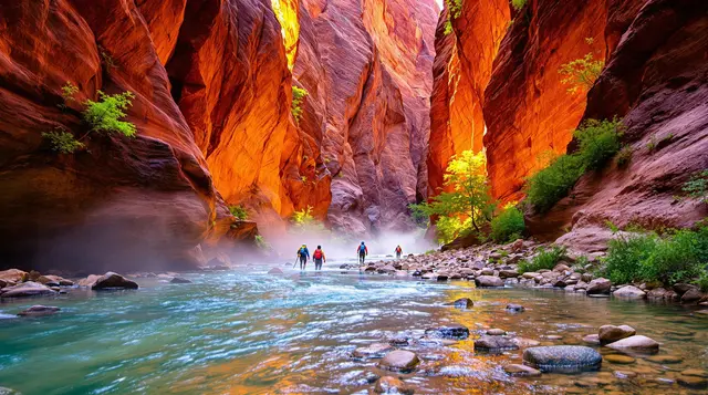
The Narrows in Zion National Park is one of those hikes where you don’t just walk on solid ground—you wade through water. This unique hike involves walking through the Virgin River, with the canyon walls rising on either side, sometimes towering hundreds of feet. The path itself is ever-changing, with the river’s water level fluctuating depending on recent rainfall, making the trail unpredictable and occasionally dangerous. The hike is not particularly long, but the water can be swift, and the current powerful, adding a layer of difficulty to each step.
What sets The Narrows apart is the raw beauty of the canyon. As you walk through the water, the towering sandstone walls and the peaceful sound of flowing water create an almost surreal atmosphere. However, with the stunning views come inherent risks. Flash floods are a serious concern in this part of Zion, and hikers are advised to keep an eye on weather forecasts before embarking on the trail. The swift currents and slippery rocks can also lead to injuries if you’re not careful.
If you’re planning to hike The Narrows, make sure to pack waterproof gear, sturdy shoes, and plenty of water-resistant layers. It’s also a good idea to start early in the day and be mindful of the changing conditions. The Narrows is one of those hikes that feels like an adventure in every step, but it’s essential to respect the power of nature and prepare thoroughly before you set foot in the river.
Relevant Information:
- Best Months to Visit: May to September (Best for water levels)
- Difficulty: Moderate to high, with water hazards and uneven terrain
- Duration: 4 to 6 hours
- Distance: 6 to 10 miles (depending on the route)
- What to Expect: Water crossings, narrow canyons, flash floods
- Safety Gear: Waterproof shoes, walking stick, and dry bags
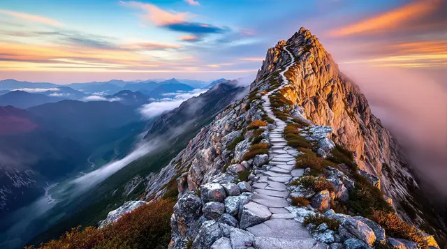
12. The Kjeragbolten, Norway

For those with a serious fear of heights (or maybe even a healthy appreciation for danger), the Kjeragbolten hike in Norway is an experience like no other. The trail itself is challenging enough, involving steep climbs, rocky paths, and dramatic drops, but what sets it apart is the final destination: a boulder wedged between two cliffs, dangling more than 1,000 meters above the Lysefjord. If you’re brave enough to stand on the boulder, it feels as though you’re floating above the fjord, with nothing but the sheer drop below.
The Kjeragbolten hike is not for the faint of heart, and it requires both physical and mental endurance. As you ascend, you’ll encounter sections of the trail that are exposed to strong winds, and the final stretch involves scrambling over rocks and narrow ledges. But once you reach the boulder, the sense of accomplishment is palpable. The view from Kjeragbolten is breathtaking, offering a panorama of the surrounding mountains and fjord, making all the hard work worthwhile.
While the hike is incredibly rewarding, it’s important to remember the risks. The weather can change rapidly in Norway, and the steep cliffs and narrow paths can be dangerous, especially during the winter months. It’s vital to take proper precautions—stay on the trail, wear sturdy boots, and always check the weather conditions before starting. If you’re looking for a thrilling adventure with a breathtaking payoff, Kjeragbolten is one hike you’ll never forget.
Relevant Information:
- Best Months to Visit: June to September (for the safest conditions)
- Difficulty: High, steep climbs and rocky terrain
- Duration: 6 to 8 hours
- Distance: 10 kilometers round-trip
- What to Expect: Steep inclines, high winds, boulder scrambling
- Safety Gear: Good hiking boots, windproof clothing, and gloves