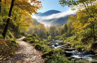
Heat shimmers off stone and a river murmurs somewhere below, yet the surprise is how many horizons feel undiscovered. We crave that jolt—wonder, risk, the breath you catch at a precipice when boots edge forward. With crowds surging and bucket lists growing noisy, choosing wilder alternatives matters more than ever.
Here, the path bends toward narrower shadows, deeper echoes, and moments that reset your internal compass. You’ll trade traffic for solitude, postcards for stories, and come back changed in small, durable ways. Stay with me: pages map where to go, when to go, and how to make it sing beautifully.
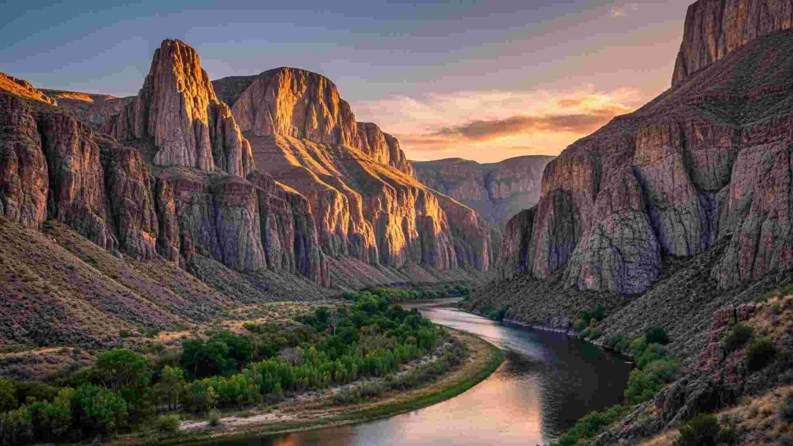
1. Zion Canyon, Utah

Zion feels alive. Cottonwoods ripple along the Virgin River while thousand-foot cliffs burn orange at golden hour. And the hiking here? World-class. Angels Landing now requires a permit—allocated by a seasonal lottery and a day-before lottery—to thin crowds on the narrow chains section. In spring and fall, the free Zion Canyon shuttle replaces private cars on the scenic drive, typically March–November (plus late-December holidays), so you hop between trailheads without traffic headaches.
For water lovers, the Narrows is the headliner. Bottom-up day hikers don’t need a permit but must turn around at Big Springs; the route closes when river flow exceeds 150 cfs or during flash-flood warnings—rules that save lives when snowmelt spikes the current. Top-down or overnight requires a wilderness permit. Here’s what that means in practice: check the current CFS before you gear up, and remember that waist-deep crossings at ~70 cfs are common.
Practical Information:
- Season & weather: Peak in spring–fall; summer heat in the 90s °F common; Narrows often closes in high spring runoff.
- Getting around: Free shuttle March–Nov; scenic drive closed to private vehicles in that period.
- Time needed: 2–3 days for Zion Canyon highlights; add a day for Kolob Canyons.
- Must-try: Angels Landing (lottery), Riverside Walk into the Narrows, Canyon Overlook at sunrise.
- Budget: Standard NPS entrance fee or $80 America the Beautiful Pass covers multiple parks for a year.
- Cultural etiquette: You’re visiting Southern Paiute homelands; leave artifacts where they lie, and don’t touch rock art.
- Photo ops: Cottonwoods along the Virgin River, Court of the Patriarchs, golden light on the canyon walls.
2. Yosemite Valley, California

Granite monoliths, thunderous waterfalls, and a valley that feels cathedral-quiet at dawn. Yosemite Valley concentrates the icons—Tunnel View, El Capitan, Half Dome—and the park’s free shuttles keep you moving: Valleywide buses every ~12–22 minutes, 7 am–10 pm, plus a more frequent East Valley route. In 2025, Tuolumne Meadows’ local shuttle did not operate, so plan accordingly if you’re heading high.
Road access shifts with weather. Glacier Point Road typically opens in May and closes in November; in 2025, it opened May 10. Winter brings chain controls and periodic closures—always check current conditions. Entry rules saw lots of headlines: as of late-2025, you didn’t need a reservation to drive into Yosemite, though the $35/vehicle fee still applies. (The park has piloted timed entry on select peak dates in prior years—verify before you go.)
Practical Information:
- Season & weather: Peak late spring–early fall; waterfalls roar in May–June; summer heat in valley, cool nights at elevation.
- Getting around: Free shuttles 7 am–10 pm; YARTS buses connect gateway town.
- Time needed: 2–3 days for Valley + Glacier Point; add 1–2 days for Tioga Road high country when open.
- Must-try: Mist Trail to Vernal/Nevada Falls, Glacier Point overlook (road status permitting).
- Budget: $35/vehicle for seven days; America the Beautiful Pass covers multiple parks. Cashless at entrances.
- Cultural etiquette: Valley is the homeland of the Ahwahneechee (Southern Sierra Miwuk); visit the Indian Village of Ahwahnee and museum respectfully.
- Photo ops: Tunnel View at sunset, reflections at Sentinel Bridge, spring dogwoods after rain.
3. Bryce Canyon, Utah
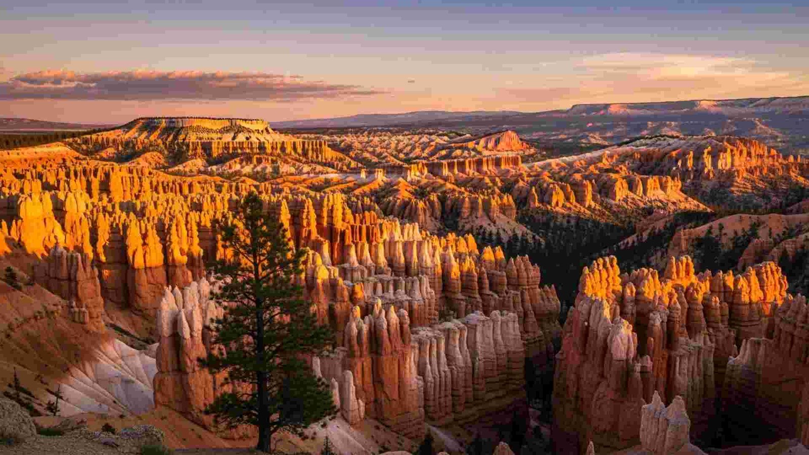
Bryce isn’t a single canyon but a staircase of natural amphitheaters carved into candy-colored limestone. Those forests of spires, the hoodoos, form when water, ice, and gravity chip away at the Claron Formation. It’s not just pretty—over 170 nights a year drop below freezing, turbocharging the freeze-thaw process that sculpts new pinnacles. That’s why the scenery literally changes over time.
Morning is magic. Light hits the Bryce Amphitheater and the whole basin glows. To reduce congestion, the park runs a free seasonal shuttle (most years April–October; in 2025 it operated until Oct 19). Trails like Navajo Loop + Queen’s Garden pair short distances with big payoffs—switchbacks, windows, and hoodoos with names like Thor’s Hammer.
Practical Information:
- Season & weather: High elevation (8,000–9,100 ft) means cool nights year-round; expect snow into spring.
- Getting around: Free park shuttle through peak season; park once, ride often.
- Time needed: 1–2 days covers main overlooks plus a sunrise hike.
- Must-try: Sunrise at Sunrise Point; Navajo Loop + Queen’s Garden combo.
- Budget: Standard NPS fees or annual pass; shuttle is free.
- Cultural etiquette: Acknowledge Paiute stories; don’t stack rocks or shortcut switchbacks—erosion here is fast.
- Photo ops: Golden hour across the Amphitheater; winter rim with fresh snow frosting the hoodoos.
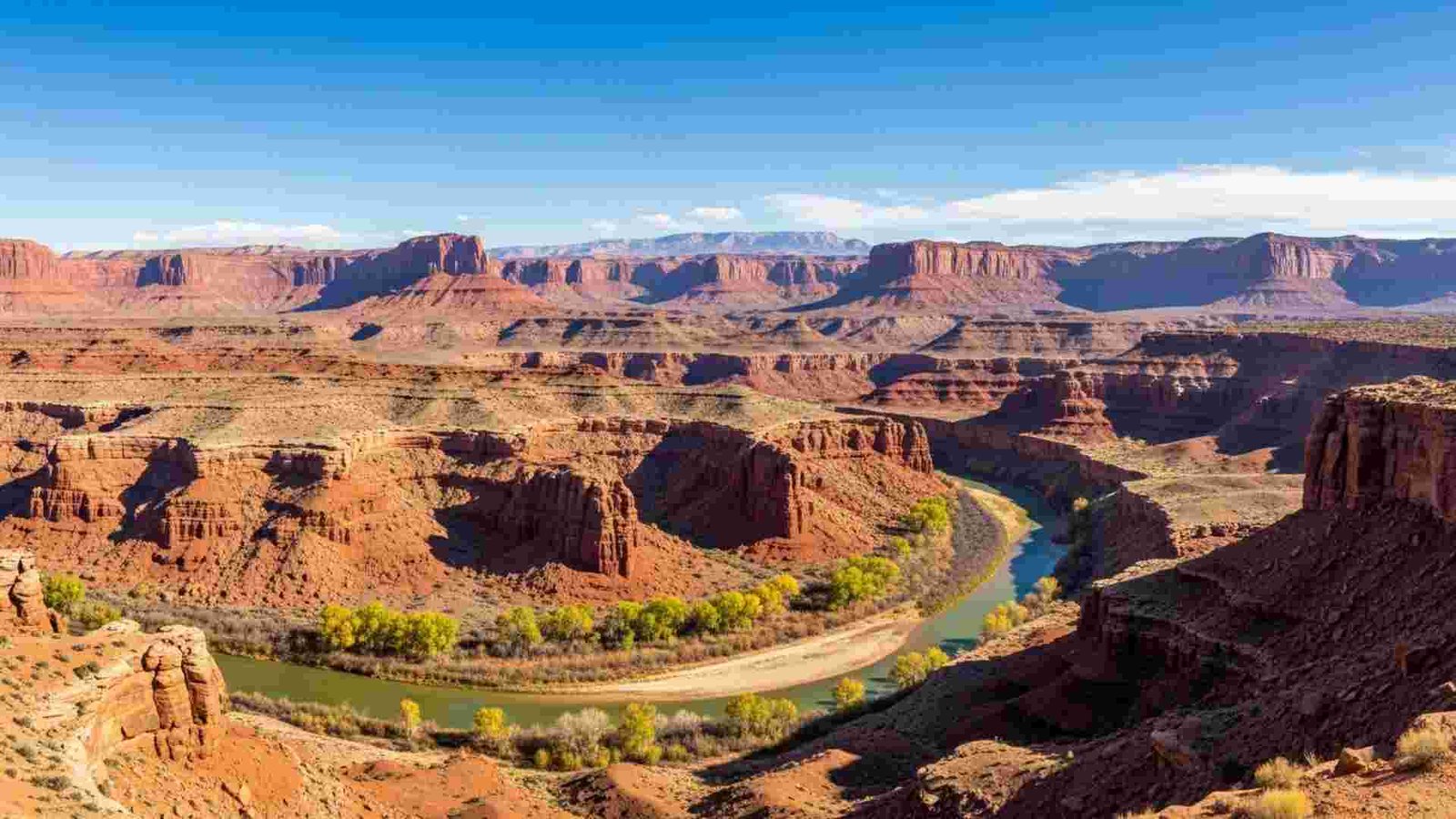
4. Canyonlands National Park, Utah

Four distinct districts split by two rivers, each with a different vibe. Most first-timers hit Island in the Sky for sweeping mesa-top overlooks; backcountry folks dream about the White Rim Road, a 100-mile 4×4 and bike loop that circles the mesa. To protect the experience, the park limits day-use to 50 vehicles and 50 mountain bikes per day on White Rim, with small group caps and route-specific rules.
Permits matter here. Day-use permits are required for White Rim and key Needles roads like Elephant Hill; overnights need backcountry permits; and river trips require separate approvals. The upside of all that paperwork? Big-sky solitude. And if you’re chasing sunrise, the short walk to Mesa Arch frames a canyonscape that looks pulled from a movie trailer.
Practical Information:
- Season & weather: Spring and fall are sweet spots; summer heat can exceed 100 °F on exposed slickrock.
- Getting around: Drive to overlooks in Island in the Sky; permits mandatory for White Rim/Elephant Hill day-use; no timed entry to the park itself.
- Time needed: 1–2 days for overlooks; 2–4 days for a full White Rim loop.
- Must-try: Shafer Trail viewpoint, Murphy Point at sunset, Chesler Park (Needles).
- Budget: Standard NPS entrance or annual pass; day-use permits are free but limited, so snag them at 8 am the day prior.
- Cultural etiquette: Rock art and archeological sites are sacred—look, don’t touch—and never camp within site boundaries.
- Photo ops: Mesa Arch at sunrise; long-lens layers from Grand View Point.
5. Grand Canyon of the Yellowstone, Wyoming
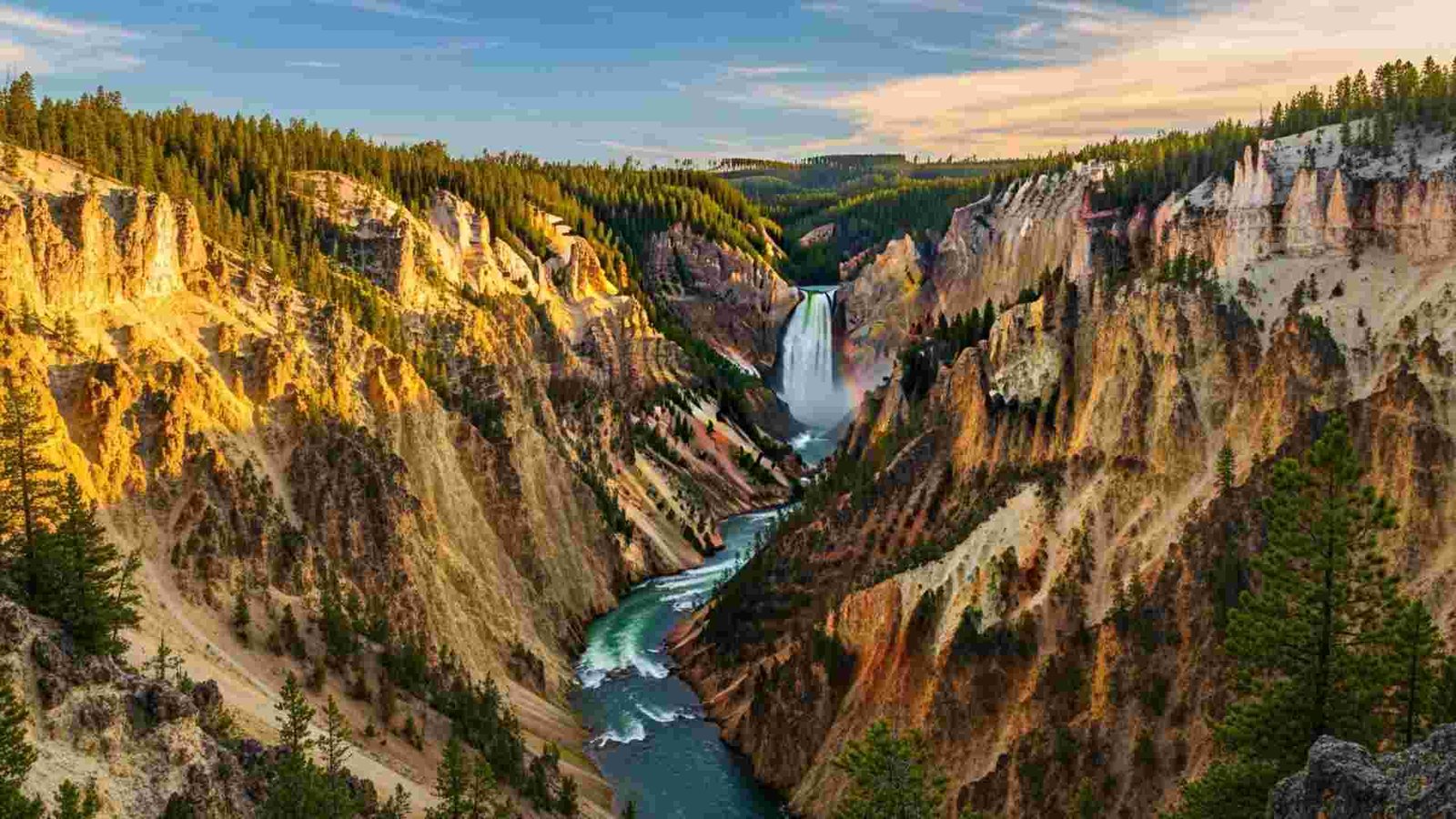
If Yellowstone had a heartbeat, it’s the thundering Lower Falls—308 ft of mist that paints rainbows by mid-morning. The canyon itself slices deep—roughly 800–1,200 ft from rim to river and over 20 miles long—its pastel yellows and reds baked by ancient hydrothermal chemistry. Artist Point offers the classic composition, but both North and South Rim drives hide smaller viewpoints worth lingering at.
Geology isn’t just backdrop here—it’s the story. The river plunges over tougher volcanic rock at the brink, then chews through hydrothermally altered layers downstream, which erode faster and give the walls their color. That contrast likely explains why the Lower Falls forms where it does. Trails and overlooks are short but can be steep; carry layers, as wind funnels through the gorge even on warm days.
Practical Informationn:
- Season & weather: Peak June–September; cool mornings even in summer at ~6,000 ft.
- Getting around: Drive the North/South Rim roads; short walks to Lookout, Artist, and Uncle Tom’s area (if open).
- Time needed: Half day to a full day for canyon overlooks plus hikes.
- Must-try: Artist Point viewpoint; Brink of the Lower Falls (steep).
- Budget: Standard park entrance or interagency pass.
- Cultural etiquette: Yellowstone is connected to many tribal nations—treat thermal and cultural features with respect; stay on boardwalks and signed trails.
- Photo ops: Early light at Artist Point; late-day rainbows in Lower Falls spray.
6. Hells Canyon, Idaho/Oregon — go deeper than “deepest”

Hells Canyon isn’t just North America’s deepest river gorge (~7,993 ft). It’s also a living geology lab that, according to 2025 research, carved far faster and more recently than once thought—major incision kicking into gear roughly 2.1 million years ago. Here’s what that means on the ground: sheer walls, abrupt benches, and a river corridor that feels young and muscular, with jet boats and rafts threading big, pool-and-drop whitewater between long, quiet flats.
Want the rim-to-river contrast in a single afternoon? Drive the gravel road to Hat Point Overlook for a 6,000-plus-foot lookdown to the Snake, then book a jet-boat run or guided raft to feel that vertical in your legs the next morning. And if you’re after solitude, target the shoulder weeks around permit season—riverside camps feel wilder once the launch calendars thin.
Practical Information:
- When to go: May–Sept for river season; shoulder months are quieter at viewpoints like Hat Point.
- Permits: Private floats and powerboats require permits year-round; lottery/primary season runs from the Friday before Memorial Day–Sept 10. Self-issue permits outside that window. Required gear includes PFDs, fire pan, and human-waste carry-out system.
- Access & logistics: Snake River launches via HCNRA sites; rim views from Hat Point Overlook (USFS directions from Imnaha). Check current road status for FS-39 and spurs.
- Why it’s special: Deepest river gorge in North America (~7,993 ft); recent research dates major incision to ~2.1 million years ago—young, fast-cut geology.
7. Waimea Canyon, Kauaʻi — the color story

Waimea’s drama isn’t just depth; it’s color in motion. Rain darkens the reds, trade-wind clouds slide shadows across forests, and waterfalls stitch the walls after storms. The canyon runs about 14 miles long and dives more than 3,600 ft, with lookouts that fan from roadside pull-offs to short walks with views of Niʻihau on clear days. You’re looking at erosion layered on an ancient shield volcano—basalt rusting to that signature red.
Morning after a passing shower, when the air clears and Waipoʻo Falls shows white against the red. Or late afternoon when trade clouds thin and the amphitheater glows. If you like pairing big views with light hiking, do the Canyon Trail to Waipoʻo Falls from nearby Kōkeʻe. (It’s the “two-parks-in-one” day that locals love.)
Practical Information:
- Hours & fees: Open daylight hours. Non-resident fees: $5/person + $10/vehicle (valid same day for Waimea Canyon and Kōkeʻe). Hawaiʻi residents free with ID.
- Best windows: Mornings after passing showers (waterfalls pop; clearer air). Pair canyon overlooks with short walks in Kōkeʻe.
- Getting there: Paved scenic drive with multiple signed lookouts; weather can shift quickly—rotate between overlooks if clouds sock in.
8. Antelope Canyon, AZ (Navajo Nation)
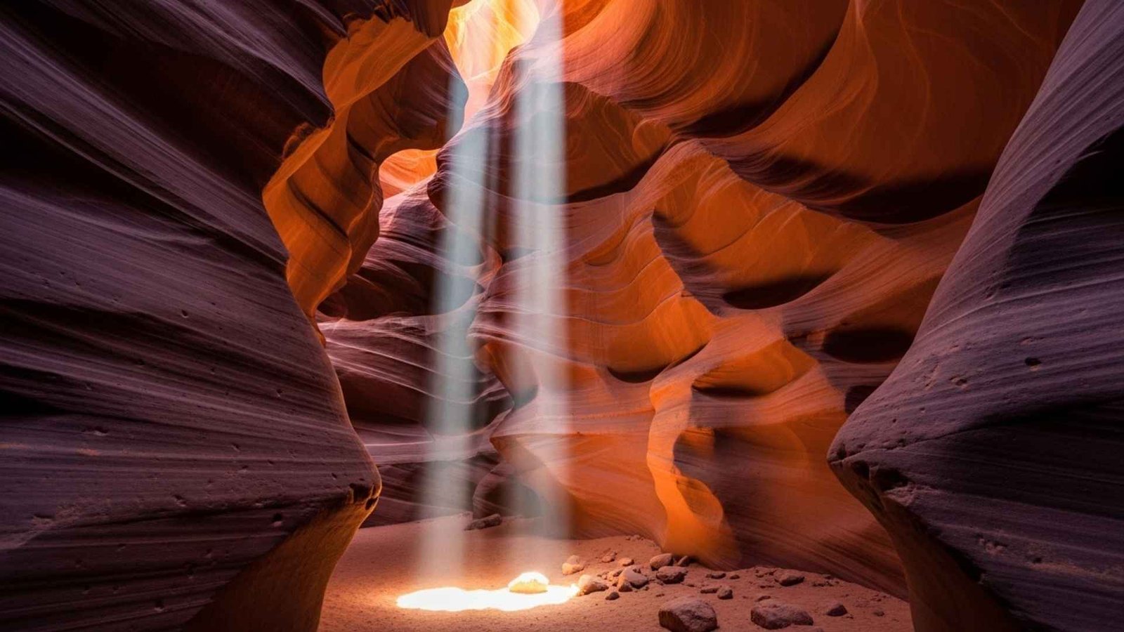
Think of Antelope as a family of slots with different personalities, all on Navajo land and only accessible with authorized guides. Upper Antelope is the cathedral—wide floor, vertical walls, and the famous light beams in the midday window (roughly 11 a.m.–1:30 p.m., late spring through early fall on sunny days). Lower Antelope is the puzzle—stairs, squeezes, and fewer beams but more playful shapes. Canyon X offers space and quieter tours.
Chasing the beams? Book Upper on a clear day in May–September around midday. Want fewer elbows in your frame? Aim for shoulder seasons or pick non-beam times. And if storms are in the forecast, know that tours pause for flash-flood safety—slot canyons are powerful places first, photo backdrops second. A separate Navajo entry fee applies in addition to your tour.
Practical Information:
- Access rule: Guided tours only; Navajo Nation entry fee $8/person per location in addition to tour price. No drones.
- Choosing a slot: Upper = wide floor + famous light beams; Lower = ladders, tighter passage; Canyon X = roomier, quieter tours. Beam window most reliable ~11:00–1:30 on sunny days late Mar–early Oct.
- Plan ahead: Peak dates sell out weeks in advance; tours pause for flash-flood safety when storms threaten—build flexibility into your day.
9. Columbia River Gorge, OR/WA
The Gorge is an 80-mile-long river canyon cut up to 4,000 ft deep, stitched with waterfalls and winds that turn Hood River into a windsurfing playground. Crowds cluster at Multnomah Falls (620 ft), so here’s the twist—ride the Columbia Gorge Express and skip the parking drama. Buses run seven days a week from Portland with stops at Multnomah, Cascade Locks, and Hood River.
Spring wildflower days on Rowena Plateau? Bus out, hike, and linger for sunset without watching the clock on a parking slot. Summer waterfall hop? Pair the bus with a local shuttle to weave stops without moving your car. And in 2025–spring 2026, note the Historic Highway closure east of Multnomah Falls for viaduct repairs—another reason to let transit do the work.
Practical Information:
- Car-free win: Columbia Gorge Express runs 7 days/week linking Portland ↔ Multnomah Falls ↔ Cascade Locks ↔ Hood River (connections to The Dalles). Typical one-way fare ~$10..
- Peak controls: Timed-use permit required for the I-84 Exit 31 Multnomah Falls lot 9 a.m.–6 p.m., May 23–Sept 1, 2025. Arrive outside the window or ride transit to skip the parking permit.
- 2025–26 detour note: Section of the Historic Columbia River Highway (US-30) east of Multnomah Falls closed Oct 2025–spring 2026 for viaduct repairs; access remains via I-84.
10. Black Canyon of the Gunnison, CO

Many parks wow with breadth; Black Canyon stuns with sudden vertical. The Painted Wall rises 2,250 ft, the tallest cliff in Colorado, and the Gunnison River drops ~43 ft per mile on average, spiking to ~240 ft per mile at Chasm View. That gradient isn’t abstract—you’ll hear the river long before you see it, echoing up the slot.
Crave a strenuous scramble? Inner Canyon routes require free wilderness permits and serious comfort on loose, steep terrain; in late 2025, some South Rim routes were closed post-fire—always check current status. More of a sky-watcher? International Dark Sky Park status makes the South Rim campground a stars-first pick on moonless nights.
Practical Information:
- Rim vs. river: Painted Wall = 2,250 ft, tallest cliff in Colorado. River gradient averages ~43 ft/mi, peaking ~240 ft/mi at Chasm View—you’ll hear it before you see it.
- Permits & closures: Starting in 2025, inner-canyon day and overnight use on South Rim routes requires advance reservations on Recreation.gov. After the South Rim Fire (summer 2025), the South Rim road and VC later reopened—always check current alerts.
- Night skies: Certified International Dark Sky Park; bring a red-light headlamp and plan around the moon phase.
11. Paria Canyon–Vermilion Cliffs Wilderness, AZ/UT
Low, amber light skims over sandstone ribs, and suddenly the corridor narrows until the sky is a ribbon. You feel it more than you see it—Buckskin Gulch carving ahead for miles, widely regarded as one of the longest and deepest slot canyons on the planet. Paria’s appeal isn’t just scale; it’s the mood swings: sunlit amphitheaters, knee-deep water, and quiet benches where swallows stitch the silence. Overnight use is capped at just 20 people per day, which is why it still feels like true wilderness even as its fame grows.
Here’s the practical core. Overnight permits are required and scarce (book online; pick up in person). Fees run $5 per person per day for overnights; day hikers pay $6 per person per day, and both must display permit receipts at the trailhead. Human-waste bags are mandatory throughout Buckskin and Paria, and groups are limited to 10 people; day-use has no total daily cap but the 10-person group limit still applies. Entry via Wire Pass, White House, Buckskin Gulch, or Lees Ferry gives you four distinct trip flavors, from tight slots to broad, varnished walls.
Practical Informatio:
- Best seasons: Late Apr–Jun and late Sep–Nov to avoid monsoon/peak flood risk; always check the Flash Flood Potential before entering slot sections.
- Permits & fees: Overnight quota 20 people/day; book in advance ($5 per person/dog per day + $6 reservation fee). Day-use $6 per person/dog at trailheads (e.g., Wire Pass/Buckskin). Human-waste bags required in Buckskin/Paria.
- Access tips: Common entries: Wire Pass, Buckskin, White House. Overnight permit pickup at Kanab Visitor Center or Page–Lake Powell HUB.
12. Santa Elena Canyon, Big Bend NP (TX)
Stand on the gravel bar and look up. Canyon walls here rise to about 1,500 feet, and the river is literally the border—Mexico on one side, Texas on the other. The front-of-park experience is wonderfully simple: a short trail (~1.6 miles round trip; ~80 feet of gain) climbs switchbacks to a balcony above the Rio Grande, then slips into polished narrows where sound bounces like a drum. It’s the kind of spot where you linger longer than planned.
If you’re thinking boats, here’s what matters. The classic 19-mile Lajitas-to-Santa Elena float starts mellow, then tightens in the final seven miles, with Rock Slide rapid hitting Class IV at certain flows. NPS guidance is blunt: 300–600 CFS is great for open boats; above 600 CFS is raft territory, and novices should rethink it. On foot, know that Terlingua Creek can make the trail impassable after rains; ask a ranger about current conditions and never force a crossing.
Practical Information:
- Hike quick facts: 1.6-mile RT, ~80 ft gain; can be impassable when Terlingua Creek is high.
- River trips: Popular day/overnight float; Rock Slide rapid can reach Class IV at certain levels. Target ~300–600 CFS for open boats; novices should avoid >600 CFS. Backcountry river permit required.
- Logistics: Put-in/take-out access at Santa Elena Canyon River Takeout; check current river levels on NPS before committing.
13. Coyote Gulch, GSENM / Glen Canyon NRA (UT)

flowing water, hanging gardens, and stone architecture you can actually live with for a weekend. Jacob Hamblin Arch spans the creek like a doorway; Coyote Natural Bridge bends the light a different way; seeps keep the corridor green even in hard summers. It’s immersive without being extreme—if you choose the right route.
Backcountry permits are required for overnight trips, issued in person (day hiking typically doesn’t require one). The NPS strongly discourages the “water tank/Jacob Hamblin” friction-descent route unless you’re equipped and experienced; ropes placed by others aren’t maintained and can be dangerous. Safer entries include Hurricane Wash or Red Well; the Crack-in-the-Wall exit climbs roughly 700 feet of dune—a calf burner with views for days.
Practical Information:
- Permits & rules: Overnight backcountry permit required; group size ≤12; human waste must be packed out; no fires. Permits issued at Escalante Interagency Visitor Center or entry trailheads.
- Season & access: Year-round, but spring/fall are most comfortable. Expect rough dirt roads to trailheads and water/wet slickrock along the route.
- Popular routes: Hurricane Wash or Red Well for gentler entry; be prepared for slickrock scrambles near Jacob Hamblin Arch/Crack-in-the-Wall.
14. Palo Duro Canyon State Park (TX)

You roll the rim road and the land falls away into a tangle of red walls and striped “Spanish Skirts.” No need to squint: TPWD calls it the second-largest canyon in the United States, and the nickname “Grand Canyon of Texas” fits the first time you see the amphitheaters swing open. The vibe is part geologic show, part living museum—CCC stonework on the rim, Longhorn programs in season, and camp loops tucked into cottonwood shade. Daily entrance is $8/adult, and reservations are recommended in busy months.
The marquee hike is the Lighthouse Trail—~5.5 miles round trip to a 300-plus-foot hoodoo that glows at golden hour. The official guide hammers heat reality: carry 1 gallon of water per person (and pet), and think hard before starting when temps spike; rescues can take hours. Trails here can close for wet conditions or excessive heat, so check status the morning you go.
Practical Information:
- Fees & reservations: $8 adult day-use; reserve passes/campsites in advance during busy periods.
- Signature hike: Lighthouse Trail ~5.5 miles RT; in heat, don’t start ≥80°F, carry 1 gallon of water per person (and pet).
- Only-here extra: TEXAS Outdoor Musical runs June–August at the park’s Pioneer Amphitheater (check current season dates).
15. Red River Gorge Geological Area (KY)

Here’s what I mean by “layers.” You come for a ridge walk and end up threading natural arches and cliffline ledges with Appalachian forest spilling to the horizon. The Auxier Ridge–Double Arch loop is the locals’ classic—airy but reasonable, photogenic without gimmicks—and the access road even drives through the one-lane Nada Tunnel, a 1900s rail bore that still feels like a time machine.
Logistics are refreshingly clear. Backcountry camping is free, but vehicles parked overnight must display a Daniel Boone National Forest recreation pass—$5/day, $7/3-day, or $50 annual per vehicle. Pick one up at Forest offices or local vendors; the Gladie Visitor Center sits in the heart of the Gorge and runs 10 a.m.–5 p.m., Thu–Sun (seasonally noted). Some cliffs and overlooks have climbing/rappelling prohibitions or seasonal protections; obey posted signs.
Practical Information:
- Passes: For backcountry camping/overnight parking in the Gorge/Indian Creek areas, display a DBNF recreation pass ($5 day / $7 three-day / $50 annual per vehicle).
- Visitor hub: Gladie Visitor Center (check seasonal hours) for maps, conditions, and cultural info.
- Driving note: Nada Tunnel is ~900 ft long, ~12 ft wide and ~13 ft high—one lane, so large vehicles should use alternate entrances (via KY-715 or north side of KY-77).
Conclusion:
Grand Canyon gets the headlines, but these 15 canyons prove America’s wild drama stretches far beyond one rim. Pick your flavor—slot shadows, river roar, alpine walls—and plan around seasons, permits, and transit so the big moments come easy. And remember, many of these places sit on Indigenous homelands; move with respect, stay on trail, pack out what you pack in. Choose one “over the Grand Canyon” this year, then another next—because chasing depth isn’t only about rock, it’s about how the journey changes you.