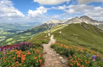
13 National Park Hikes That Require Zero Fitness (But Look Like You Climbed Everest) – Unbelievable Views You Can’t Miss!

Picture stepping into a landscape where towering cliffs, cascading waterfalls, and vast canyons unfold before your eyes — no summit required.
These trails offer awe-inspiring views that make you feel like you’ve conquered the world’s most rugged terrain, without the sweat and strain.
It’s the perfect blend of adventure and ease, a chance to explore the great outdoors in all its grandeur, without needing to be a seasoned hiker.
Whether you’re seeking serenity, a fresh perspective, or an unforgettable photo op, these hikes promise to deliver a transformative experience that will leave you wondering why you didn’t do it sooner.
1. Sentinel Dome Trail — Yosemite National Park
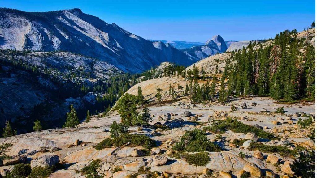
Here’s what I mean when I say this hike looks like you climbed Everest (but you didn’t need Everest-level fitness): the granite dome at the summit sits at about 8,123 ft (2,476 m) above sea level. You know that moment when you arrive at the top and the whole valley opens up before you? On Sentinel Dome, you get 360-degree views of landmarks like Half Dome, El Capitan, Yosemite Falls, and more. The trail is about 1.1 miles one way, and the elevation gain is modest, making it accessible without requiring extreme endurance. The path is well-defined, and it’s a great option if you’re looking to experience stunning views with minimal effort.
Maybe it’s just me, but I love the fact that you can reach such a lofty vantage point with relative ease. While the main trail is relatively short, it’s important to check road access before your visit, as Glacier Point Road, the main access road, is closed in winter and could be impacted by snow. For a quick summit, it’s one of the best options in Yosemite.
Key Practical Information
- Peak/Off-peak seasons & weather insights: Summer is the high season, with warm days and cool evenings. The road to Glacier Point may close in the winter, so plan ahead.
- Best ways to reach and explore: Access via Glacier Point Road, then walk the short, well-defined trail to the summit.
- Ideal duration of visit: 1-2 hours, depending on how long you spend at the summit.
- Must-try local experiences: Watch the sunset from the summit for breathtaking views of the valley and surrounding peaks.
- Budget considerations: Entrance fees apply, and accommodations in Yosemite can be pricey, so plan accordingly.
- Cultural etiquette tips: Stay on the trail to protect the fragile environment, and keep noise levels low during sunset when others are enjoying the peaceful atmosphere.
- Photography opportunities: The views from the summit of Half Dome and the Yosemite Valley are perfect for panoramic shots, particularly at sunset.
2. Cape Royal Trail — Grand Canyon National Park (North Rim)

Think about it this way: you’re strolling on a short, easy paved trail, and then boom — the rim of the Grand Canyon opens up in front of you. The Cape Royal Trail is an out-and-back trail of about 1 mile round-trip, with an elevation gain of just 65 feet. It’s accessible to almost anyone, yet it delivers some of the best panoramic views of the Grand Canyon. Along the way, you’ll encounter iconic spots like Angel’s Window — a natural stone arch that frames the canyon beautifully.
Here’s what I mean: the North Rim of the Grand Canyon is less crowded than the South Rim, so it’s perfect if you want to experience the Grand Canyon in relative solitude. You can also visit Cape Royal for a more secluded, relaxed experience compared to the busier viewpoints on the South Rim. I’m not sure if it’s always open, but the North Rim does have seasonal closures due to snow, so be sure to check road conditions if you’re visiting in the off-season.
Key Practical Information
- Peak/Off-peak seasons & weather insights: Summer is the high season, but it’s less crowded at the North Rim than the South Rim. Winter may have road closures due to snow.
- Best ways to reach and explore: Access via Cape Royal Road. From the parking area, it’s an easy, paved walk to multiple viewpoints.
- Ideal duration of visit: 30 minutes to 1 hour.
- Must-try local experiences: Watch the sunset from Cape Royal for a beautiful, less-crowded view of the canyon.
- Budget considerations: Entry fees for the Grand Canyon apply, and North Rim lodging can be more expensive due to its limited availability.
- Cultural etiquette tips: Be mindful of safety near the canyon rim, and respect the sacredness of the land to Indigenous peoples.
- Photography opportunities: Angel’s Window is a perfect photo subject, and the wide-open vistas at Cape Royal are stunning for panoramic shots.
3. Laurel Falls Trail — Great Smoky Mountains National Park
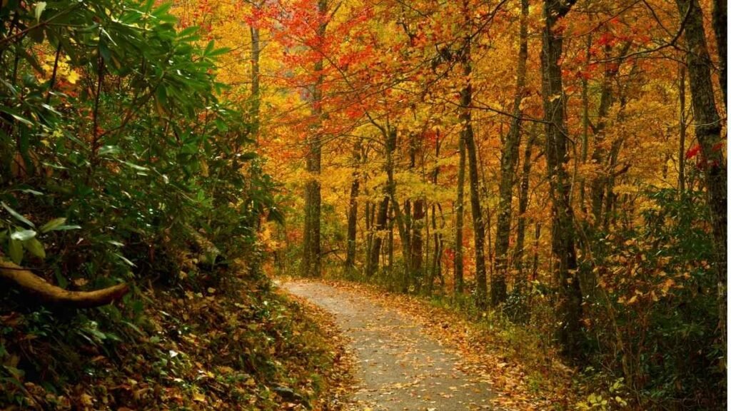
Maybe it’s just me, but a paved forest trail ending at a two-tiered waterfall feels luxurious in a national park. The Laurel Falls Trail is a 2.6-mile round-trip trail that leads to an 80-foot waterfall. The hike is very accessible, with only a modest elevation gain of about 314 feet, and it’s one of the most popular trails in the Smokies. The trail is paved, making it suitable for families, casual hikers, and anyone looking for a quick and scenic outing.
Here’s what I mean: the sound of the cascading water, the cool mist in the air, and the sight of the waterfall as it drops into a serene pool is a memory you won’t soon forget. It’s not a strenuous hike, but it packs in that “wow” factor that makes it feel like you’ve ventured deep into nature. I’m not sure about trail conditions year-round, as a major rehab project is scheduled for 2025, so make sure to check the latest updates before your visit.
Key Practical Information
- Peak/Off-peak seasons & weather insights: Fall offers beautiful foliage, while spring brings wildflowers. Be prepared for crowds during the summer months.
- Best ways to reach and explore: Park at the Laurel Falls trailhead off Little River Road, and take the paved path to the falls.
- Ideal duration of visit: About 1.5 hours, depending on your time spent at the falls.
- Must-try local experiences: Visit in the early morning to avoid crowds and enjoy a peaceful atmosphere by the falls.
- Budget considerations: No entry fee for the park, but consider the cost of nearby accommodations.
- Cultural etiquette tips: Stay on the paved trail, avoid touching vegetation, and respect the environment.
- Photography opportunities: The bridge near the falls is perfect for capturing the flow of water, and the surrounding forest adds a beautiful backdrop to the shots.
4. Ocean Path Trail — Acadia National Park
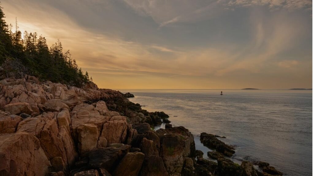
Maybe it’s just me, but there’s something magical about walking along the coast with waves crashing below, the salty air in your lungs, and the view of towering cliffs on the horizon. The Ocean Path Trail is about 4.4 miles round-trip, following the edge of the park along the ocean. It’s a relatively flat trail, with just a 337-foot elevation gain, making it accessible to a wide range of visitors. The path starts at Sand Beach and runs all the way to Otter Point, passing famous spots like Thunder Hole.
Here’s what I mean: the trail takes you through diverse coastal scenery, from serene beaches to dramatic cliffside views, and you’ll encounter ocean waves crashing into granite rocks — giving you that summit experience even though you’re not climbing a mountain. I’m not sure if the dog-friendly parts of the trail are always open, but it’s worth checking the rules, especially if you’re traveling with pets.
Key Practical Information
- Peak/Off-peak seasons & weather insights: Summer offers the best weather, but expect crowds. Fall brings fewer crowds and beautiful foliage. Winter is icy and cold but serene if you’re prepared for it.
- Best ways to reach and explore: Park at Sand Beach or along Park Loop Road, then walk along the Ocean Path.
- Ideal duration of visit: 2 to 3 hours, depending on how far you go and how many viewpoints you stop at.
- Must-try local experiences: Visit Thunder Hole at high tide to see the spectacular wave action, or catch a sunrise from Otter Cliffs for beautiful coastal views.
- Budget considerations: Acadia requires an entrance fee, and lodging in Bar Harbor can be on the expensive side, though there are budget-friendly options if you plan ahead.
- Cultural etiquette tips: Be mindful of the trail’s fragile environment, stay on designated paths, and leash your dog if bringing one.
- Photography opportunities: Capture the waves crashing at Thunder Hole and the sweeping views from Otter Cliffs, particularly at sunrise or sunset.
5. Big Room Trail — Carlsbad Caverns National Park

Here’s what I mean when I say it looks like you climbed Everest — you step into a cavernous void that spans acres, with soaring ceilings and massive formations, yet you’re walking on a mostly flat, accessible paved trail. The Big Room is the largest single cave chamber by volume in North America, covering about 8.2 acres (3.3 hectares). The trail is around 1.25 miles and takes about 1.5 hours to complete. You can either take the elevator down (most popular), or if you’re feeling adventurous, you can hike down through the natural entrance.
Here’s what I mean: once inside the cavern, you’ll stroll past dramatic stalactites, stalagmites, and rock formations, making it feel like you’re in an underground world that few have ever seen. It’s an accessible yet awe-inspiring adventure. I’m not sure if timed entry is always required, but make sure to book ahead to avoid waiting.
Key Practical Information
- Peak/Off-peak seasons & weather insights: Summer is peak season, but the cavern temperature remains cool year-round (around 56°F/13°C).
- Best ways to reach and explore: Drive to Carlsbad Caverns and purchase a timed-entry ticket. Use the elevator to access the Big Room, or hike the natural entrance if you want to add some exercise.
- Ideal duration of visit: 2 to 3 hours to fully enjoy the cave experience.
- Must-try local experiences: Witness the nightly bat flight in the summer — it’s a spectacle when thousands of bats exit the cave at dusk.
- Budget considerations: There is an entry fee, and lodging is available in nearby Carlsbad.
- Cultural etiquette tips: Don’t touch the cave formations; stay on the paved trail for safety.
- Photography opportunities: The massive cavern walls and unique formations provide endless photo opportunities, but the lighting is dim, so use a high ISO setting or a tripod.
6. Santa Elena Canyon Trail — Big Bend National Park
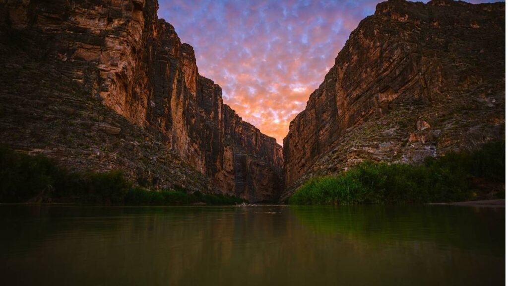
At first glance, Big Bend National Park in West Texas might seem like a desert with little to offer. But here’s what I mean when I say the Santa Elena Canyon Trail is a hidden gem: this relatively short 1.7-mile trail takes you into the dramatic, narrow canyon carved by the Rio Grande River. The trail is relatively easy, with only about 200 feet of elevation gain, making it approachable for a range of hikers, yet it packs in some of the most jaw-dropping views in the park. The canyon walls rise nearly 1,500 feet, creating a towering, almost surreal environment where you feel like you’ve stumbled into another world.
Think about it this way: when you get to the end of the trail, you’re rewarded with a view of the Rio Grande winding through the canyon, with towering cliffs on either side, and if you time your visit right, you may even catch a peaceful moment where the only sound is the water trickling by. Maybe it’s just me, but there’s something magical about walking a trail where you’re so close to the international border — with Mexico just on the other side of the river.
Key Practical Information
- Peak/Off-peak seasons & weather insights: Spring and fall are the best times to visit, as summer temperatures can soar above 100°F.
- Best ways to reach and explore: Access the trail from the Santa Elena Canyon Trailhead along the Ross Maxwell Scenic Drive.
- Ideal duration of visit: About 1 hour for the trail; make sure to spend some time at the end soaking in the views.
- Must-try local experiences: Take a boat tour along the Rio Grande to get a different perspective of the canyon’s cliffs.
- Photography opportunities: Capture the canyon walls as the light shifts in the late afternoon or evening — the shadows are striking.
7. Queens Garden Trail — Bryce Canyon National Park

There’s a reason Bryce Canyon is famous for its hoodoos — those towering spires of rock that make the landscape look like something out of a dream. The Queens Garden Trail is an absolute must-see because it’s considered one of the easiest trails to experience Bryce’s iconic rock formations up close. This 1.8-mile trail descends into the heart of Bryce Canyon, and even though it’s a short hike, it offers some of the best views of the park’s natural architecture. The elevation loss is about 320 feet, but the trail is well-maintained and moderate enough for most hikers.
Think about it this way: when you enter the trail, you’re immediately surrounded by the towering, thin rock formations that make Bryce Canyon so famous. You feel like you’ve stepped into an alien landscape. Maybe it’s just me, but the contrast between the reddish-orange rocks and the bright blue sky on a clear day is breathtaking. The trail even connects to the more challenging Navajo Loop, so if you’re feeling adventurous, you can extend your hike.
Key Practical Information
- Peak/Off-peak seasons & weather insights: Summer sees the most visitors, so visiting in spring or fall gives you cooler weather and fewer crowds.
- Best ways to reach and explore: Park at the Sunrise Point, then take the Queens Garden Trail for a round-trip to the canyon floor.
- Ideal duration of visit: 1-2 hours, depending on how much time you spend at the viewpoints.
- Must-try local experiences: Hike up to Sunrise Point for the early morning glow on the hoodoos.
- Budget considerations: Bryce has a park entrance fee, and camping or lodging options are available at various price points.
- Photography opportunities: The hoodoos make for dramatic shots, especially when light filters through them at sunrise or sunset.
8. Rim Trail – Paved Segment Between Sunrise and Sunset Points — Bryce Canyon National Park

Here’s an insider tip for those looking for a quick but immersive experience in Bryce Canyon: the Rim Trail connects two of the park’s most famous points — Sunrise and Sunset Points. This paved section of the Rim Trail is an easy 1-mile walk, making it perfect for those who want great views without much effort. What sets this apart, though, is how it delivers one of the best panoramic views of Bryce Canyon’s otherworldly landscape, all while being flat and paved.
You know that moment when you’re walking along the rim, and you suddenly get an unobstructed view of the entire canyon? That’s what the Rim Trail gives you. Whether you’re at sunrise or sunset, the light on the hoodoos is truly mesmerizing. The best part? You don’t need to be an experienced hiker to enjoy these views, and the paved path makes it accessible for wheelchairs and strollers too. It’s easy, beautiful, and perfect for those short on time but wanting a taste of Bryce’s natural beauty.
Key Practical Information
- Peak/Off-peak seasons & weather insights: Mornings and evenings, especially at sunrise and sunset, are the best times to visit to see the hoodoos lit up with golden light.
- Best ways to reach and explore: Park at either Sunrise Point or Sunset Point and walk the paved trail in either direction.
- Ideal duration of visit: 30-45 minutes, depending on how much time you want to spend soaking in the views.
- Must-try local experiences: Come at sunrise or sunset for the best light; you’ll be able to see the canyon at its most colorful.
- Budget considerations: The park charges an entrance fee, but it’s easy to visit on a budget with picnic areas and affordable accommodation options nearby.
- Photography opportunities: The light at sunrise and sunset gives the canyon’s hoodoos incredible color, perfect for dramatic shots.
9. Hall of Mosses Trail — Olympic National Park

Maybe it’s just me, but stepping into the Hall of Mosses feels like walking into a fantasy world. This 0.8-mile loop trail in Olympic National Park takes you deep into the Hoh Rainforest, one of the world’s largest temperate rainforests. The trail is easy, with minimal elevation gain, and you’ll be surrounded by thick, green moss covering nearly everything — trees, rocks, and the forest floor. It’s a magical experience, and the silence, broken only by the soft rustling of leaves, adds to the peaceful ambiance.
Think about it this way: when you walk through the Hall of Mosses, you’re stepping into one of the most unique ecosystems in the U.S. The towering trees and their moss-covered limbs feel like something out of a mythical forest. This place is home to a variety of plant species, and the lush greenery is beautiful no matter the season. I’m not sure if visitors always realize it, but the temperate rainforest has such a rich diversity of plant life — it’s practically a living museum of botanical wonders.
Key Practical Information
- Peak/Off-peak seasons & weather insights: Rain is frequent, especially in fall and winter, so be prepared. Summer provides milder temperatures, but crowds are higher.
- Best ways to reach and explore: Park at the Hoh Rainforest Visitor Center and take the short, well-maintained trail into the moss-filled forest.
- Ideal duration of visit: 45-60 minutes for the loop, with additional time if you’d like to explore the area further.
- Must-try local experiences: Explore nearby trails to see more of the rainforest or visit the Hoh River for more breathtaking views.
- Photography opportunities: The soft light filtering through the moss-covered trees creates a dreamy atmosphere that’s perfect for photos.
10. Canyon Overlook Trail — Zion National Park

Zion National Park is known for its awe-inspiring canyons and towering rock formations, but here’s an insider tip: the Canyon Overlook Trail is an excellent way to get breathtaking views with minimal effort. This 1-mile round-trip trail is relatively short, but the vistas from the end are nothing short of spectacular. The trail is a bit rocky, but it’s suitable for most people, and it delivers panoramic views of Zion Canyon, including features like the Great White Throne and the Watchman.
You know that moment when you realize that a short trail has led to some of the most dramatic scenery in the park? That’s Canyon Overlook. The hike doesn’t take long, but the views make it feel like you’ve climbed much higher. I’m not sure why more visitors don’t take this trail — it’s often overshadowed by the famous Angel’s Landing and The Narrows hikes, but it’s a perfect option for those looking for something quick and stunning.
Key Practical Information
- Peak/Off-peak seasons & weather insights: Spring and fall are the best seasons for fewer crowds and cooler temperatures.
- Best ways to reach and explore: Park at the Canyon Overlook Trailhead, located just off the main Zion Canyon Scenic Drive.
- Ideal duration of visit: 1-1.5 hours for the hike.
- Must-try local experiences: If you’re up for more, try the Hidden Canyon Trail or take a shuttle to other park areas.
- Photography opportunities: The view of Zion Canyon from the end of the trail is perfect for wide-angle shots.
11. Dream & Emerald Lakes Trail — Rocky Mountain National Park
Rocky Mountain National Park is known for its towering peaks, but Dream and Emerald Lakes offer a much more accessible yet still equally stunning experience. The 3.6-mile round-trip hike takes you past two lakes nestled beneath the park’s soaring peaks. With a modest elevation gain of 700 feet, this trail is moderate but approachable. It offers some of the park’s best alpine lake scenery without the long, grueling climbs.
Maybe it’s just me, but there’s something about reaching the shores of these high-altitude lakes, with crystal-clear waters reflecting the surrounding peaks, that makes you feel on top of the world. The trail gets you there without the extreme effort of other, more strenuous hikes in the park.
Key Practical Information
- Peak/Off-peak seasons & weather insights: Summer is ideal, but crowds can be high; fall offers cooler temperatures and fewer visitors.
- Best ways to reach and explore: Start at the Bear Lake Trailhead for easy access to the trail.
- Ideal duration of visit: 2-3 hours for the hike, plus time to enjoy the lakes.
- Must-try local experiences: Hike up to the lakes early in the morning for serene views and fewer crowds.
- Photography opportunities: The lakes are stunning, especially with the surrounding snow-capped peaks in the background.
12. Big Trees Trail — Sequoia National Park
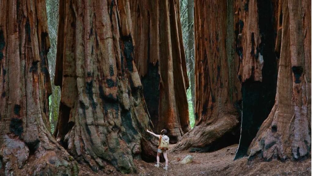
Imagine walking beneath the world’s tallest trees, with towering sequoias stretching up toward the sky. That’s what you get on the Big Trees Trail in Sequoia National Park. This 0.75-mile loop is one of the park’s easiest trails, taking you through a grove of ancient trees, including the General Sherman Tree, the largest tree by volume on Earth. It’s a relatively flat, paved trail, so it’s easy to navigate, yet it brings you up close to the awe-inspiring beauty of these ancient giants.
Maybe it’s just me, but standing next to these enormous trees, which can be over 275 feet tall, makes you feel incredibly small. The cool, shaded trail offers a refreshing break from the warmer, higher altitudes of the park. Despite its short length, the trail is full of surprises, and you’ll see some of the park’s most iconic features, like the General Sherman Tree and the Giant Forest.
Key Practical Information
- Peak/Off-peak seasons & weather insights: The best times to visit are spring and fall, avoiding the summer crowds and extreme heat at lower elevations.
- Best ways to reach and explore: Take the Generals Highway to the Giant Forest area, where you’ll find the trailhead.
- Ideal duration of visit: 30 minutes to 1 hour, depending on how long you linger at the trees.
- Must-try local experiences: Visit General Sherman and hike some of the other accessible trails in the Giant Forest for even more majestic sequoias.
- Budget considerations: Park entrance fees apply, but there are campsites and accommodations available in the area at various price points.
- Photography opportunities: The immense size of the sequoias is breathtaking, and the trail offers plenty of opportunities for dramatic shots, especially with the sunlight filtering through the trees.
13. Bristlecone Loop Trail — Great Basin National Park

Bristlecone Pine trees are famous for their incredible longevity, and on the Bristlecone Loop Trail in Great Basin National Park, you can stand among some of the oldest living trees on Earth. This 0.6-mile loop trail is short and easy, but it offers a fascinating opportunity to witness the gnarled, ancient bristlecone pines that have lived for thousands of years. The trail is located at an altitude of 10,000 feet, so expect to feel the thinner air, but it’s still an accessible hike for most visitors.
Here’s what I mean: walking the Bristlecone Loop gives you a sense of history and resilience. You’re standing among trees that have withstood harsh conditions for over 4,000 years, making them some of the oldest organisms on the planet. Maybe it’s just me, but there’s something awe-inspiring about being in the presence of such ancient life forms. Despite its brevity, the trail offers amazing views of the Wheeler Peak area and the surrounding wilderness, and the ancient bristlecone pines are an unforgettable sight.
Key Practical Information
- Peak/Off-peak seasons & weather insights: Summer is best for visiting, but the higher altitude can make winter access difficult.
- Best ways to reach and explore: Access the trail from the Wheeler Peak Campground in the park. The trailhead is easy to find.
- Ideal duration of visit: About 30-45 minutes for the loop.
- Must-try local experiences: If you’re up for more, the Wheeler Peak hike offers incredible high-altitude views, and stargazing here is one of the best in the country due to minimal light pollution.
- Photography opportunities: The ancient, twisted trees make for striking photos, especially against the backdrop of the mountains.