There’s something exhilarating about pushing your limits, isn’t there? The adrenaline rush, the heart-pounding anticipation, the unknown that makes every turn feel like a daring adventure.
Some roads, however, don’t just test your courage—they demand it. These treacherous paths are not for the faint of heart. They twist, climb, and drop through some of the most dangerous landscapes on Earth, where one wrong move could mean disaster.
But for those brave enough to drive them, the reward is worth the risk—spectacular views, untamed beauty, and a journey that will forever change the way you think about adventure.
1. North Yungas Road, Bolivia
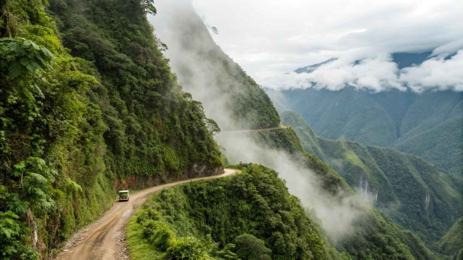
Ah, the North Yungas Road—also known as “Death Road”. If you’ve ever seen a documentary about terrifying driving experiences, chances are this road was featured. This notorious 43-mile stretch connects La Paz, Bolivia, with the Yungas region, and the experience here is not for the faint of heart. The road is carved into cliffs, often shrouded by fog, with no guardrails. It drops thousands of feet straight down. Add to this the frequent rain and rockfalls, and it’s a driving challenge that will make even the most seasoned driver sweat bullets.
In the past, North Yungas Road was one of the deadliest routes on Earth, with over 300 deaths annually. But don’t let that deter you. Over the years, authorities have made significant improvements, making the route less deadly, but it still packs a punch. The steep hairpin curves, the unpaved surface, and the lack of space for two vehicles to pass are just a few of the obstacles you’ll face. And it’s a drive that constantly keeps you on edge, with the view from above always reminding you how small the road is compared to the massive mountain range beside you.
Whether you’re driving or just taking a tour, the road’s scenic beauty is as jaw-dropping as its dangers. Winding through lush rainforests and offering incredible views of the Amazon Basin, it’s both a deathtrap and a dream for adrenaline junkies and nature lovers alike. But be warned—this isn’t a place to test your skills without a seasoned local guide. Trust me, there’s a reason why it’s called “The Road of Death.”
Other Relevant Information:
- Best Months to Visit: May to October (Dry Season)
- Distance: 43 miles (69 km)
- Altitude: From 4,650 meters (15,255 feet) down to 1,200 meters (3,937 feet)
- Driving Conditions: Narrow, often foggy, and prone to landslides
- Best For: Adventure travelers, cyclists (yes, it’s a popular spot for downhill biking!)
- Tip: Don’t take this road at night or in heavy rain. Stick to daytime and clear weather.
2. Guoliang Tunnel Road, China
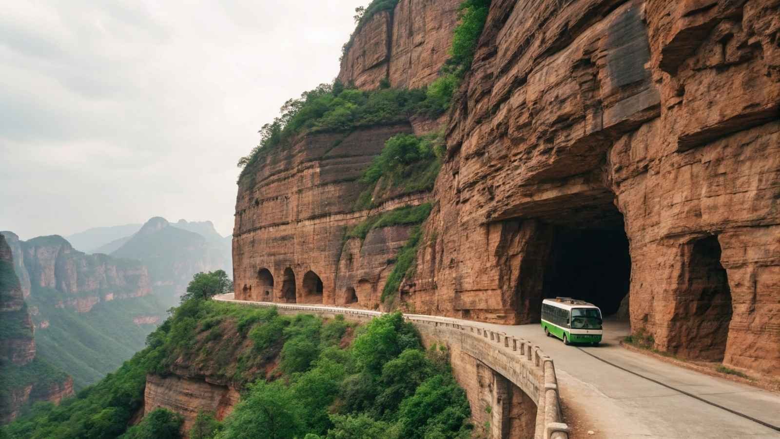
Now, Guoliang Tunnel Road in China—let’s talk about a masterpiece of engineering that doubles as a death trap. It’s one of the most unbelievable roads you’ll ever drive on. Carved entirely through the mountain, this road takes you through a tunnel-like path that cuts through solid rock. Imagine driving through a narrow cliffside with views of a steep drop on one side—that’s what this road feels like. It’s almost as though the road was chiseled out to challenge anyone brave enough to drive through it.
The road was originally carved by local villagers in the 1970s to connect their remote village to the outside world. It’s now a popular tourist attraction, but only for the brave. The road is winding, with steep climbs, sharp turns, and sections where the cliff walls feel just inches away from your car. It doesn’t help that the tunnel sections are low-ceilinged and often have sharp rock protrusions. Every second feels like you’re threading the needle between life and death. What’s even more remarkable is that despite the danger, this road is still used by locals and tourists alike.
If you’re a driver with nerves of steel, you’ll appreciate the stunning mountain views and the raw, rugged appeal of the route. However, if you’re not accustomed to tight spaces, a trip here might just rattle your confidence. It’s the kind of adventure where you’re constantly wondering whether you should be taking photos or focusing on not driving off the cliff.
Other Relevant Information:
- Best Months to Visit: April to October (Avoid winter months for snow and icy roads)
- Length: 1.2 miles (2 kilometers) of tunnel plus surrounding road
- Altitude: 1,800 meters (5,906 feet)
- Driving Conditions: Narrow, winding, sharp curves with limited visibility
- Best For: Thrill-seekers, photographers, and anyone with a love for engineering marvels
- Tip: Avoid visiting during the peak tourist season in summer to skip crowds and get a better feel of the road’s serenity.
3. The Highway of Death, Russia

The Highway of Death—sounds like something out of an action movie, right? Well, this 34-mile stretch in Russia’s Ural Mountains lives up to its name. The road itself is treacherous and notorious for extremely dangerous weather conditions, including ice, snow, and intense fog. But it’s not just the weather—it’s the road’s lack of guardrails, high cliffs, and sharp turns that make it one of the most terrifying drives on Earth.
To make matters worse, the highway is prone to accidents, some of which result from poorly marked lanes or roads that suddenly narrow. In winter, the roads are often covered in ice, turning every turn and hill into a potential disaster. It’s said that local drivers know the best tricks to navigate the road, and they even take extreme caution. The sharp bends and sheer cliffs will have you gripping the wheel with everything you’ve got.
If you’re a fan of death-defying roads with snow-capped mountains and unpredictable twists, this one should make your bucket list. But only if you’re up for the challenge and well-prepared. Make no mistake—the highway lives up to its ominous name.
Other Relevant Information:
- Best Months to Visit: Late spring to early fall (avoid winter and icy roads)
- Distance: 34 miles (55 kilometers)
- Altitude: Varies, but the region’s mountain range can rise to 1,500 meters (4,921 feet)
- Driving Conditions: Ice, snow, fog, sharp bends, and no guardrails
- Best For: Experienced drivers with a high tolerance for danger and an affinity for extreme weather conditions
- Tip: If you decide to tackle this road, make sure your vehicle is winterized and equipped for snow.
4. Atlantic Road, Norway
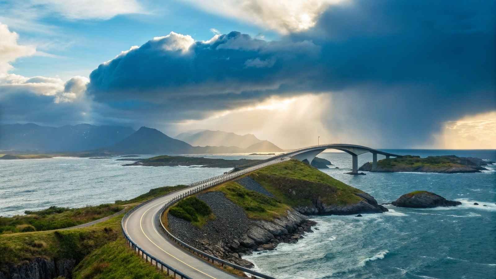
The Atlantic Road in Norway is a stunning drive that blends natural beauty with some serious white-knuckle moments. This 8.3-mile stretch connects a series of islands, and the road is often buffeted by storms coming from the North Sea. But it’s the sheer dramatic curves and wild weather conditions that make it one of the most dangerous drives in the world. When the winds are howling and the waves crash against the sides of the road, it’s easy to see why this route has a reputation for making drivers nervous.
The road features several bridges, each one seemingly higher and more exposed than the last. One of the most famous bridges, Storseisundet, is so curved that it looks almost impossible to drive on. The sight of the road disappearing into the ocean below makes it both terrifying and exhilarating. On a clear day, the views are breathtaking, with the surrounding islands and the sea stretching into infinity.
However, driving here requires your full attention, as the weather can change in an instant. The road becomes slippery in the rain, and you may even encounter sudden fogs that make navigation tricky. If you’re lucky enough to experience it under clear skies, it’s an unforgettable journey. But even when the weather turns, the road remains a stunning spectacle that makes the danger worth it.
Other Relevant Information:
- Best Months to Visit: June to August (for the best weather and visibility)
- Distance: 8.3 miles (13.3 kilometers)
- Altitude: Varies, but reaches approximately 75 meters (246 feet) at its highest
- Driving Conditions: Windy, foggy, exposed bridges
- Best For: Scenic drives, photography enthusiasts, adrenaline junkies
- Tip: Watch out for stormy conditions and avoid driving during the winter months when the road can be covered in ice.
5. Trollstigen, Norway
Another Norwegian gem, Trollstigen, is a road that lives up to its name. The “Troll’s Path” is a series of 21 hairpin turns that lead you up a steep mountain pass with sheer drops on either side. The road is narrow, with almost no barriers to keep you from the edge, and if you’re not careful, a wrong move could send you over the edge. It’s not just about the driving—it’s about the high-altitude experience. The road itself climbs to a dizzying height of 850 meters (2,788 feet), providing stunning views that make you feel like you’re on top of the world.
But driving here isn’t easy, especially when it’s snowy or foggy. The sharp corners and the narrow roadway make it a challenging and dangerous experience. However, it’s a road you have to drive at least once in your lifetime if you’re a thrill-seeker. If you dare to drive it, you’ll be rewarded with the ultimate adrenaline rush.
Every curve in the road feels like a battle with gravity itself, and the landscape views are worth the perilous journey. The road was built in the 1930s and remains a marvel of engineering, though it’s not for anyone looking for a laid-back cruise.
Other Relevant Information:
- Best Months to Visit: June to September (it’s closed in the winter due to snow)
- Length: 10 kilometers (6 miles)
- Altitude: 850 meters (2,788 feet)
- Driving Conditions: Hairpin turns, narrow roadways, steep drops
- Best For: Scenic drives, adventure enthusiasts, thrill-seekers
- Tip: Be mindful of the weather—it can change rapidly, and the road can become treacherous during rain or snow.
6. The Stelvio Pass, Italy
The Stelvio Pass in the Italian Alps isn’t just dangerous—it’s also a stunning test of endurance. As the highest paved mountain pass in the Eastern Alps, it features 48 hairpin turns that curve their way up the mountainside like a winding snake. The road is narrow, and the drop-offs on the side are enough to make any driver’s heart race. The road reaches an altitude of 2,757 meters (9,045 feet), making it one of the most famous driving challenges in Europe.
Driving here can feel like a battle with both the road and the elements. Weather conditions can change rapidly, with fog, snow, and ice making the already dangerous turns even more precarious. It’s not just the turns but the sharp inclines that’ll have you wondering if your car will make it. Still, the scenic beauty along the way is enough to distract you from the nerve-wracking journey, with views of snow-capped peaks and lush valleys that make it all worth it—if you survive, that is.
Tourists and thrill-seekers flock here to tackle its dangerous curves, and it’s a popular route for cyclists as well. However, only experienced drivers should even think of taking it on, and even then, you should be prepared to take it slow. One wrong move on the winding roads could end up with disastrous consequences.
Other Relevant Information:
- Best Months to Visit: June to September (When the road is fully open)
- Distance: 24.3 kilometers (15.1 miles)
- Altitude: 2,757 meters (9,045 feet)
- Driving Conditions: Narrow, steep, sharp hairpins, and sometimes slippery roads
- Best For: Adventurous drivers, cyclists, and road trip enthusiasts
- Tip: Drive slowly and be prepared for the weather to change in an instant.
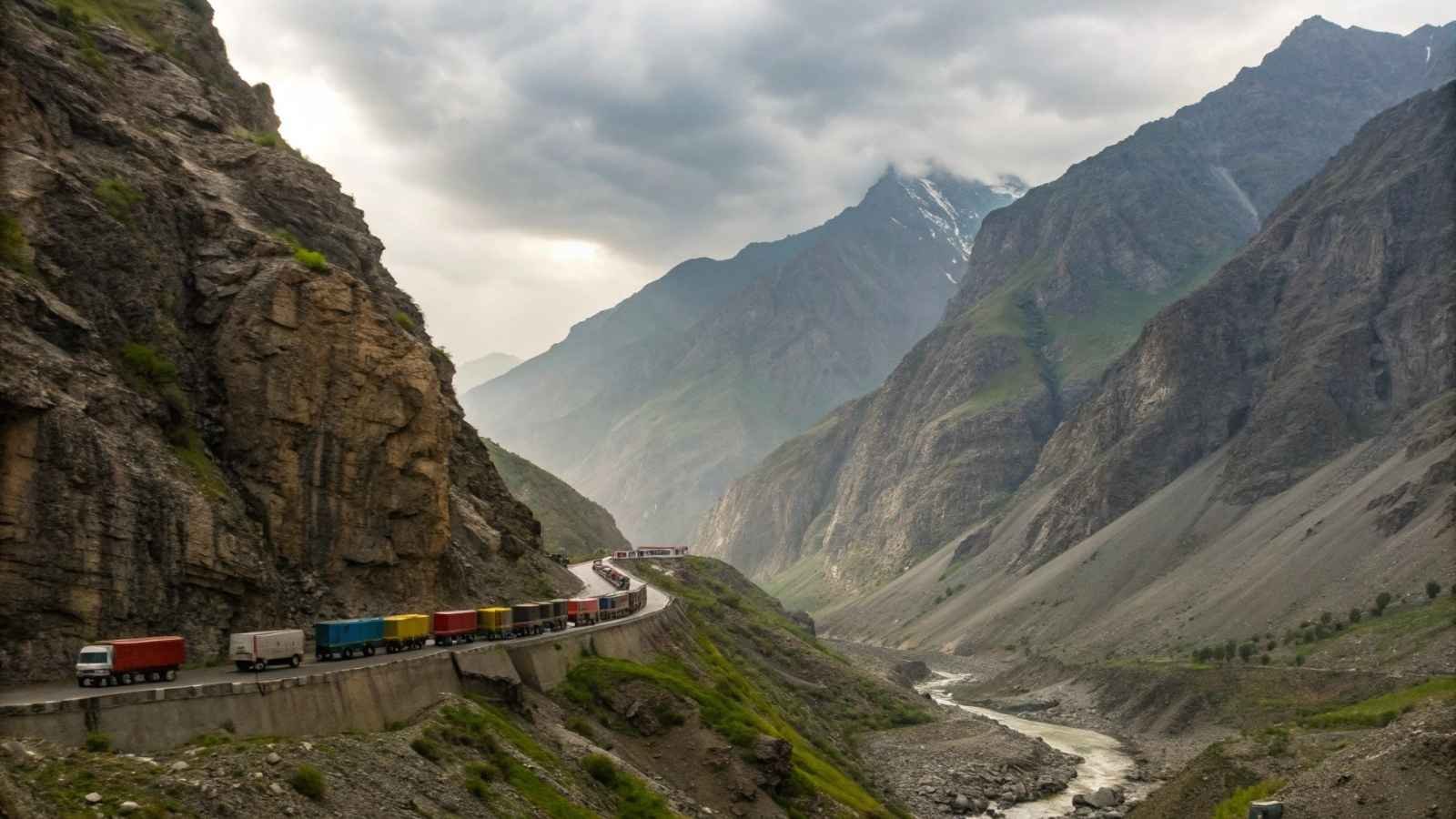
7. Siachen Glacier Road, India/Pakistan
The Siachen Glacier Road is a rugged, military-grade route that stretches through one of the harshest environments on Earth—the Siachen Glacier, located in the Karakoram Range. It’s considered one of the most dangerous roads because of its location at nearly 20,000 feet (6,096 meters) above sea level, where the altitude alone can cause serious health issues. Add to that extreme weather conditions—snow, ice, and low visibility—and you have a road that very few people ever dare to drive on.
This military road is often referred to as “the world’s highest battlefield,” due to the longstanding territorial conflict between India and Pakistan over this region. Not only is it dangerous because of its terrain and weather, but it also has limited infrastructure and very few places to take shelter in case of an emergency. Avalanches, rockslides, and unexpected military activity only add to the risks of traveling here.
Because of its high-altitude nature, only military vehicles with specialized tires and equipment are recommended for this treacherous drive. For civilians, traveling this route requires high-altitude acclimatization to avoid altitude sickness.
Other Relevant Information:
- Best Months to Visit: May to October (Avoid winter due to extreme snowstorms)
- Distance: Approx. 70 kilometers (43.5 miles)
- Altitude: Up to 20,000 feet (6,096 meters)
- Driving Conditions: High-altitude, snow, ice, avalanches
- Best For: Military personnel and extreme adventurers
- Tip: Only attempt with proper preparation and acclimatization to avoid altitude sickness.
8. Col de la Bonette, France
The Col de la Bonette is a stunning mountain pass located in the French Alps. At an altitude of 2,802 meters (9,193 feet), it’s the highest paved road in Europe, offering jaw-dropping views of the Alpine peaks. What makes this road so dangerous is not just its altitude but also the narrowness of the route, which winds sharply along hairpin bends with a steep drop to the side.
It’s a popular route for thrill-seekers and motorcycle enthusiasts, who come for the thrilling drive and scenic vistas. But don’t be fooled by the beauty of the place—the weather here can change without warning, turning a clear day into a dangerous storm within minutes. Also, the road is often covered with snow well into the summer, which increases the risk of losing traction. The drive demands expert driving skills, as the road is steep, twisting, and exposed to the elements.
For those who love to combine their drive with hiking, Col de la Bonette provides access to some incredible hiking trails and is part of the Route des Grandes Alpes, a famous road trip through the French Alps. But it’s important to remember: speeding is not your friend on this mountain road, as even the best drivers have been caught off guard by its unpredictable nature.
Other Relevant Information:
- Best Months to Visit: June to September (Be aware of snow in the spring and autumn months)
- Distance: 32 kilometers (19.9 miles)
- Altitude: 2,802 meters (9,193 feet)
- Driving Conditions: Narrow, steep, with sharp curves, and prone to snow and rain
- Best For: Motorcycle enthusiasts, road-trippers, and nature lovers
- Tip: Take your time and check the weather forecast before hitting the road.
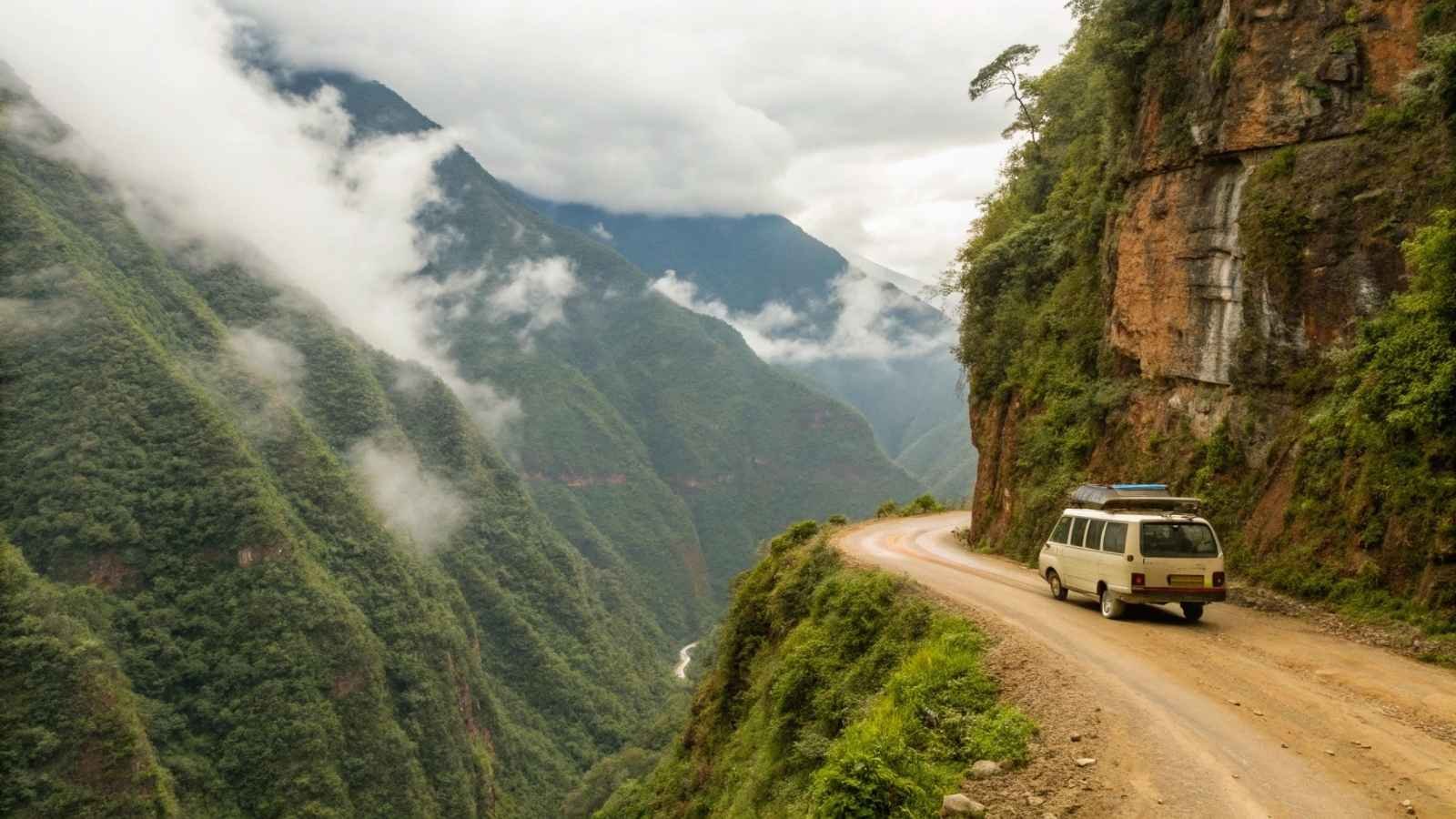
9. Carretera a Los Yungas, Bolivia
The Carretera a Los Yungas, like its infamous cousin, the North Yungas Road, is another Bolivian deathtrap that will make your pulse race. This route leads to the lush and remote Yungas region of Bolivia and is known for its ruggedness, steep drops, and hairpin curves. However, it’s the unpredictable weather, the muddy roads, and the lack of guardrails that make this road one of the most dangerous in the world.
Over the years, numerous accidents have occurred here, some of which are fatal due to the extreme conditions of the road. The climb up to Los Yungas often faces intense rainfall, making the dirt roads slippery and prone to mudslides. Buses and trucks often travel this route, making it even more dangerous for smaller vehicles and tourists.
But it’s not just about the danger; Los Yungas offers stunning views of the surrounding cloud forests and remote villages. If you dare to brave the challenge, you’ll experience a region of Bolivia few outsiders ever get to see. Take it slow, and consider a local guide if you’re new to the region.
Other Relevant Information:
- Best Months to Visit: May to October (dry season)
- Distance: Approx. 60 kilometers (37 miles)
- Altitude: Ranges from 1,200 meters (3,937 feet) to 3,000 meters (9,843 feet)
- Driving Conditions: Unpaved, steep, narrow, and prone to mudslides
- Best For: Adventurers, locals, and cycling enthusiasts
- Tip: Avoid the wet season (November to March) to minimize road hazards.
10. Skippers Canyon Road, New Zealand
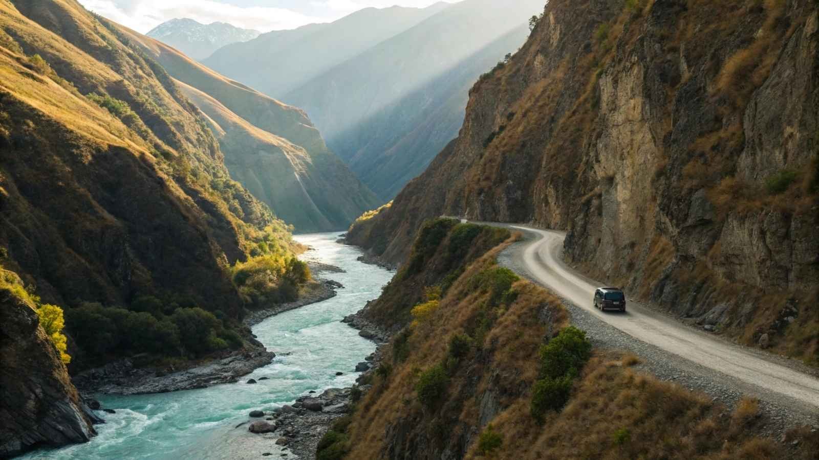
Skippers Canyon Road is one of the most terrifying drives in New Zealand, largely due to its sheer drops, narrow roads, and extremely precarious position. Located just outside Queenstown, this historic road was originally built for gold miners in the 1860s. Today, it’s still used for local traffic, but tourists flock here for the thrill of driving on one of the most hair-raising roads in the world.
The road winds along cliffs with a narrow, gravel surface—there’s barely enough room for two cars to pass. No guardrails and sharp corners leave little room for error. On top of the narrowness, the road is treacherous during rain and flash floods. The cliffs and sharp drop-offs on either side can make it feel like you’re driving straight into the abyss.
Despite its dangers, Skippers Canyon is worth the effort for those looking for a heart-pounding adventure. The scenic views of the Shotover River and the gorgeous canyon below are unforgettable. However, it’s best to hire a local guide or go with a tour operator to navigate this dangerous road safely.
Other Relevant Information:
- Best Months to Visit: November to March (summer months for better weather)
- Distance: Approx. 22 kilometers (13.7 miles)
- Altitude: 400 meters (1,312 feet) at its highest point
- Driving Conditions: Narrow, gravel, steep drops, no guardrails
- Best For: Adventure seekers, photographers, and thrill-seekers
- Tip: Do not drive here alone unless you’re a highly experienced driver.
11. Hana Highway, Hawaii, USA

The Hana Highway in Hawaii is a tropical beauty—no doubt. But don’t let its serene beauty fool you. This 64.4-mile (103.6 kilometers) route, connecting Paia to Hana on the island of Maui, is famous for its narrow twists, hairpin turns, and unpredictable weather. Unlike the winding mountain passes or high-altitude roads we’ve seen, this one’s unique because it’s wrapped in dense jungle, with numerous waterfalls and sheer cliffs often just a foot away from the road. In some places, the road is barely wide enough for a single car, making passing a challenge, especially on the sharp curves.
The drive here is nothing short of exhilarating, especially as you pass through rainforests and along dramatic coastal cliffs. But don’t get too distracted by the view—the narrow lanes, blind curves, and frequent roadworks demand your undivided attention. The weather can also change rapidly, so mudslides and rockfalls are common. You need to approach it with caution. It’s an iconic drive, but a challenging one, with more than 600 turns along the way.
For those seeking an adventure, a leisurely drive with stunning sights can quickly turn into a gripping experience. And when you reach Hana, you’ll feel a sense of accomplishment, knowing you survived one of the world’s most breathtaking and treacherous roads.
Other Relevant Information:
- Best Months to Visit: April to October (Less rain, better driving conditions)
- Distance: 64.4 miles (103.6 kilometers)
- Altitude: Sea level to 1,000 feet (305 meters)
- Driving Conditions: Narrow, one-lane bridges, tight curves, and frequent rain
- Best For: Nature lovers, photographers, and adventure seekers
- Tip: Start early to avoid traffic and fully enjoy the sights without the rush.
12. The Icefields Parkway, Canada
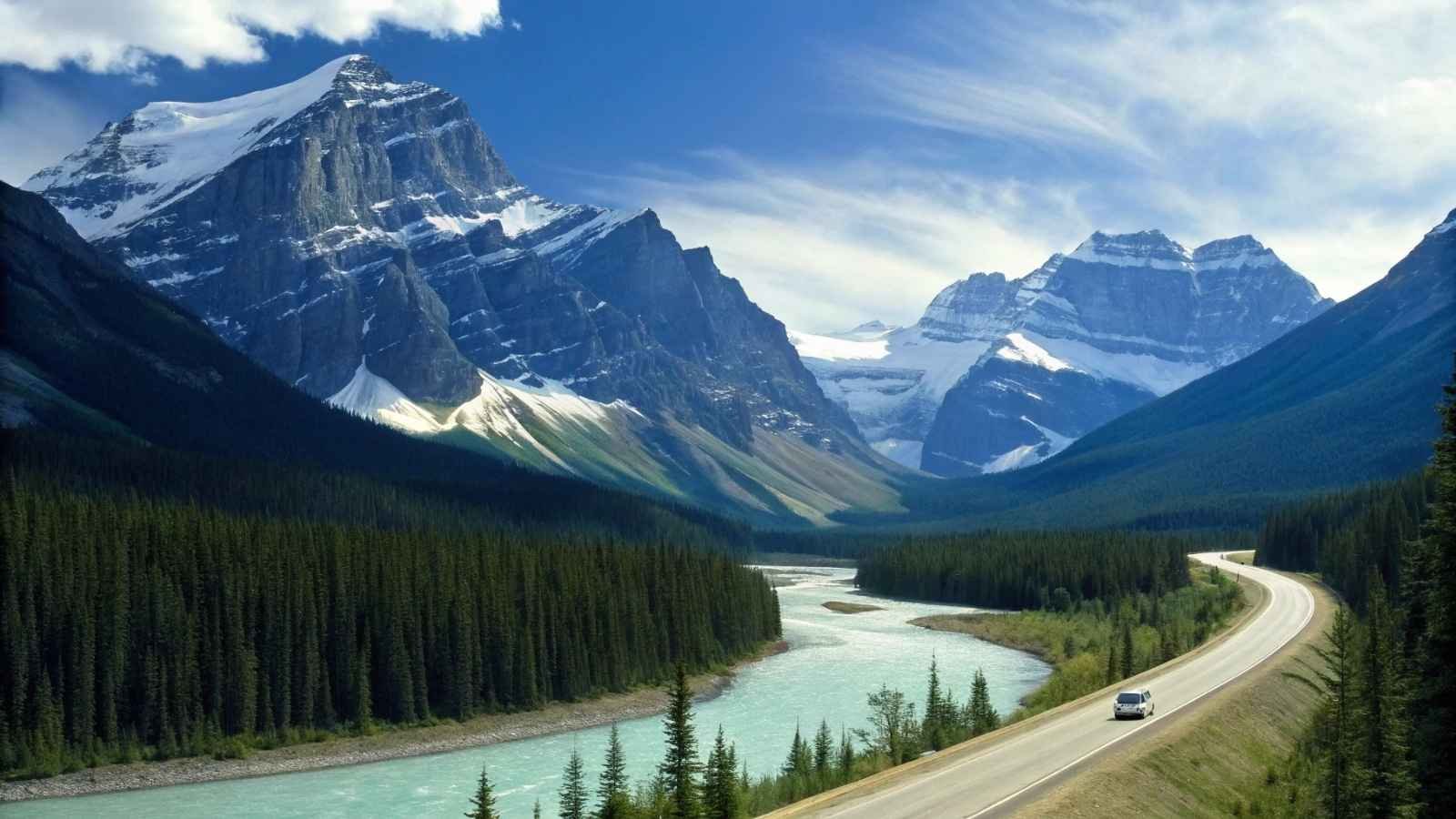
The Icefields Parkway in Canada runs between the towns of Banff and Jasper, cutting through the Canadian Rockies. It’s one of the most scenic highways in the world—and one of the most hazardous, particularly during the winter months. Snow, ice, and sudden fog make the drive difficult, even for the most experienced drivers. The road itself is often flanked by glaciers, making the dramatic landscapes both stunning and perilous. In some sections, you’re driving along cliff edges that drop sharply into raging rivers below, while the high-altitude areas can become treacherously icy.
You’ll pass some iconic sites, such as the Athabasca Glacier and Bow Lake, where even the wildlife seems to feel the raw beauty and danger of the region. But, with the scenic beauty comes a serious risk. Despite being a well-traveled tourist route, wildlife crossings, rockslides, and blizzards are common in colder months. The road also narrows in spots, creating dangerous situations for drivers who are unprepared for sudden snowfalls or low visibility.
Despite the dangers, Icefields Parkway remains a bucket-list drive for many. It’s truly an experience that will stay with you long after the journey ends.
Other Relevant Information:
- Best Months to Visit: June to September (For the best weather)
- Distance: 143 miles (230 kilometers)
- Altitude: Ranges from 1,500 meters (4,920 feet) to 2,000 meters (6,560 feet)
- Driving Conditions: Snow, ice, fog, wildlife crossings
- Best For: Nature enthusiasts, adventure lovers, photographers
- Tip: Be prepared for sudden weather changes, and always check road conditions before heading out.
13. James Dalton Highway, Alaska, USA
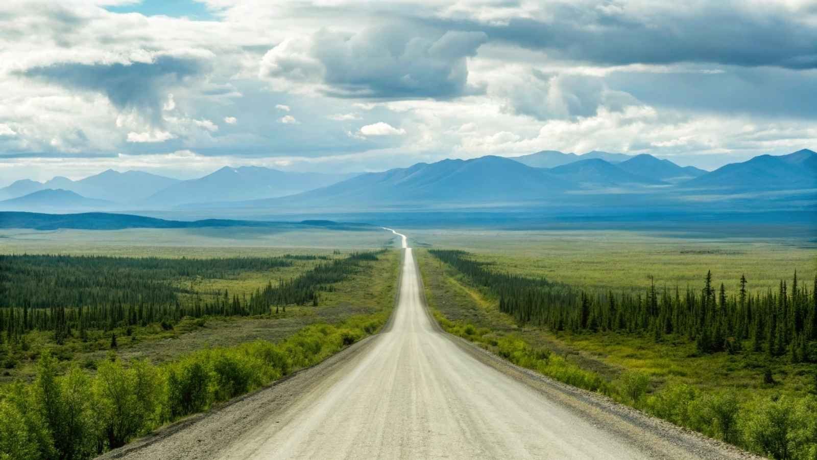
The James Dalton Highway is often referred to as “the loneliest road in America.” Located in Alaska, this 414-mile stretch connects the oil fields of Prudhoe Bay to the rest of the state, running through some of the harshest conditions known to man. The road cuts through the tundra, where windswept snow and glare ice are commonplace. The highway also passes through the Arctic Circle, where temperatures can plunge below -40°F (-40°C). Add in winds gusting up to 70 mph, and you’ve got one of the most dangerous stretches of asphalt on the planet.
Notably, the road is notorious for its isolation. If your car breaks down, help could be hours away, so it’s vital to be prepared with plenty of supplies and emergency gear. Fog, ice, and unpredictable weather make driving here a challenge. The wind chill factor makes even the thought of driving on this highway incredibly daunting.
However, for those daring enough to face the Alaskan wilderness, the James Dalton Highway offers a once-in-a-lifetime journey through the untouched beauty of the Arctic North. Just remember: The adventure is as unforgiving as it is exhilarating.
Other Relevant Information:
- Best Months to Visit: June to September (For better weather)
- Distance: 414 miles (666 kilometers)
- Altitude: Varies, with the highest point at 1,500 feet (457 meters)
- Driving Conditions: Ice, snow, high winds, and extreme cold
- Best For: Adventurers, road trippers, and extreme weather enthusiasts
- Tip: Carry an emergency kit, and make sure your vehicle is winterized before attempting the drive.
14. La Ruta de los 7 Lagos, Argentina
La Ruta de los 7 Lagos, or the Seven Lakes Route, is an incredibly scenic drive that stretches through Argentina’s Patagonia. But don’t let the picturesque surroundings fool you—this road is full of dangers. It’s a 22-mile stretch (35 kilometers) that loops through forests, mountains, and crystal-clear lakes. However, the road is full of narrow turns, steep drops, and unpredictable weather, particularly in the winter months, when snow and ice can render the road impassable.
Although the road’s natural beauty is enough to make you want to stop every few minutes, the sharp turns and rocky paths require constant attention. You’ll also find many tourists on the route, which can increase the risk of accidents. Be sure to watch out for wildlife, like the Andean fox, that may dart across the road. While the weather in summer months can be relatively manageable, winter storms can change everything.
If you’re lucky enough to drive it in good conditions, it will feel like you’re driving through a nature lover’s dream, but be ready for a handful of white-knuckle moments along the way.
Other Relevant Information:
- Best Months to Visit: November to March (For milder weather)
- Distance: 22 miles (35 kilometers)
- Altitude: Varies from sea level to 2,000 meters (6,561 feet)
- Driving Conditions: Narrow, curvy, icy in winter, wildlife crossings
- Best For: Nature lovers, photography enthusiasts, and thrill-seekers
- Tip: Drive slowly—this is not a road to rush, and always check for road closures due to snow or rockslides.
15. Zojila Pass, India
The Zojila Pass is one of the most dangerous roads in the Himalayas, sitting at an elevation of 11,575 feet (3,528 meters). Located between Srinagar and Leh in India, it’s a high-altitude pass that connects the Kashmir Valley to Ladakh. Known for its steep ascents, sharp turns, and narrow width, the road is a nerve-racking experience. During the winter months, the pass is covered in snow, making driving almost impossible, while slippery ice and rockfalls are constant threats during the rest of the year.
The pass is particularly dangerous because of its location—it sits in one of the most remote parts of India, with very little infrastructure or emergency services. Driving here feels like you’re pushing the limits of human courage. The lack of guardrails and the sheer drop-offs on the side make every curve feel like a gamble with fate. But for those who brave it, the route offers some of the most spectacular views in the world, as you wind through the dramatic mountain passes and snow-covered valleys.
Driving here requires patience and extreme caution, as well as the courage to face the unpredictable, life-threatening conditions.
Other Relevant Information:
- Best Months to Visit: May to October (Avoid winter)
- Distance: Approx. 14 miles (23 kilometers)
- Altitude: 11,575 feet (3,528 meters)
- Driving Conditions: Narrow, steep, icy, prone to rockslides
- Best For: Experienced drivers, adventurous road-trippers, and mountain lovers
- Tip: Travel with a local guide and make sure your vehicle is well-equipped for high-altitude conditions.
16. Paso de los Libertadores, Chile/Argentina
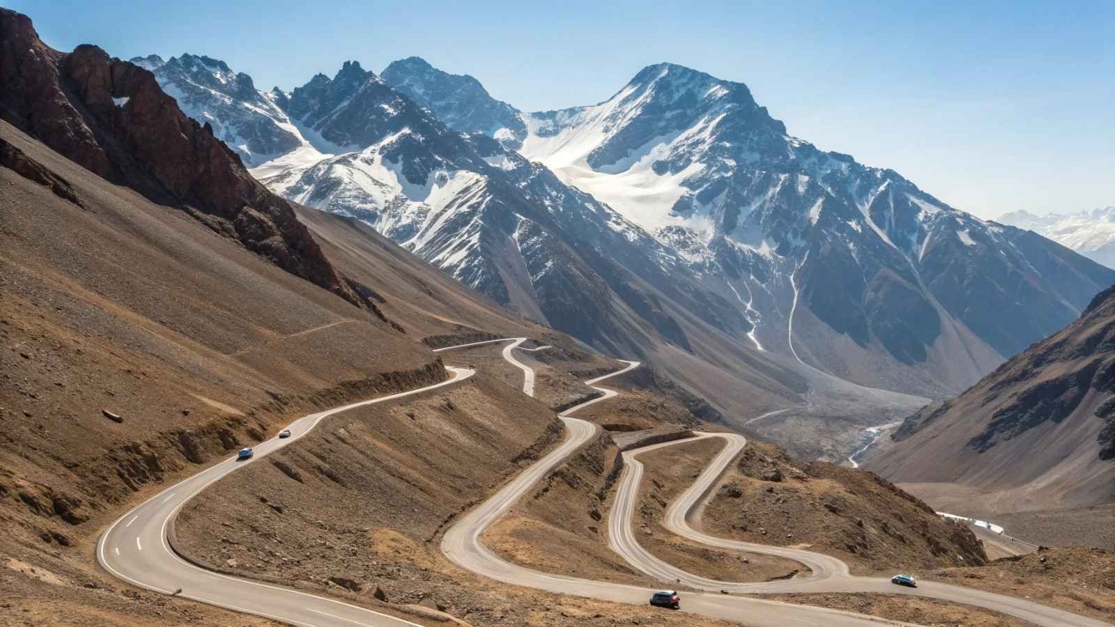
Paso de los Libertadores is one of the highest and most dangerous mountain passes connecting Chile and Argentina. Situated at 3,200 meters (10,499 feet), this road winds its way through the Andes, offering breathtaking views and terrifying drops. The road is extremely narrow, with sharp turns and unforgiving weather, especially in the winter months, when snowstorms and icy conditions make driving particularly challenging.
While it offers spectacular views of the Andes mountains, the sheer altitude and lack of guardrails make it one of the most dangerous roads to travel. The road is often covered in snow or icy patches, and the high winds can make driving even more perilous. Yet, the route is a key passageway for goods and travelers between the two countries, and it’s a must-see for adventurers brave enough to tackle it.
Despite the road’s challenges, it’s still a vital route for trade and tourism, and for those up for the challenge, the views make the drive unforgettable.
Other Relevant Information:
- Best Months to Visit: November to March (For the best weather conditions)
- Distance: Approx. 36 miles (58 kilometers)
- Altitude: 3,200 meters (10,499 feet)
- Driving Conditions: Narrow, high winds, snow, icy conditions
- Best For: Adventurers, cross-border travelers, and photographers
- Tip: Check the weather forecast before attempting this road, and be prepared for sudden changes.