Ever dreamt of stepping into the wild and testing your limits? Picture yourself pushing past physical and mental barriers, conquering challenges that leave you breathless, but rewarded with views that make every step worth it.
These journeys aren’t for the faint of heart—they’re for those who crave adventure, and seek to stand face-to-face with nature in its rawest form.
As you lace up your boots and venture into some of the toughest landscapes, you’ll experience not just the thrill of the climb, but a deeper connection to the wilderness. Ready to discover what it truly means to challenge yourself? Let’s dive in.
1. Pacific Crest Trail (California, Oregon, Washington)
The Pacific Crest Trail (PCT) is one of the most iconic and challenging backpacking routes in the US. Stretching over 2,650 miles from the southern border of California up to Canada, it crosses through the Sierra Nevada and Cascade ranges, offering diverse landscapes that range from deserts to lush, alpine forests. This trail is no cakewalk—backpackers need stamina, preparation, and mental toughness to complete it. You’ll face everything from extreme altitude to unpredictable weather, and be required to navigate through remote wilderness areas.
One of the biggest challenges on the PCT is the sheer length of the trail. Even if you decide to tackle just a section of it, you’re likely to encounter challenging ascents, descending switchbacks, and the occasional snowfield that may linger long into the summer months. It’s also a test of mental endurance. For instance, on the desert portion of the trail in southern California, water sources can be few and far between, making water management crucial for survival. I remember coming across a hiker who shared how grateful they were for their water filtration system—it was a game-changer.
As you progress north, you’ll pass through areas of true solitude—sometimes you can go days without encountering another person. The isolation, though, is what makes the PCT such a rewarding experience for many. It gives you the chance to fully connect with nature, pushing yourself beyond what you thought possible.
- Best Months to Visit: Late spring to early fall (May to September)
- Difficulty Level: Very challenging (especially if you’re attempting the entire trail)
- Elevation Gain: 300,000 feet+
- Total Length: 2,650 miles
- Key Gear: Ultra-light backpacking gear, water filtration system, a good navigation tool
- Notable Highlights: Sierra Nevada Mountains, Crater Lake, Mount Hood
2. John Muir Trail (California)
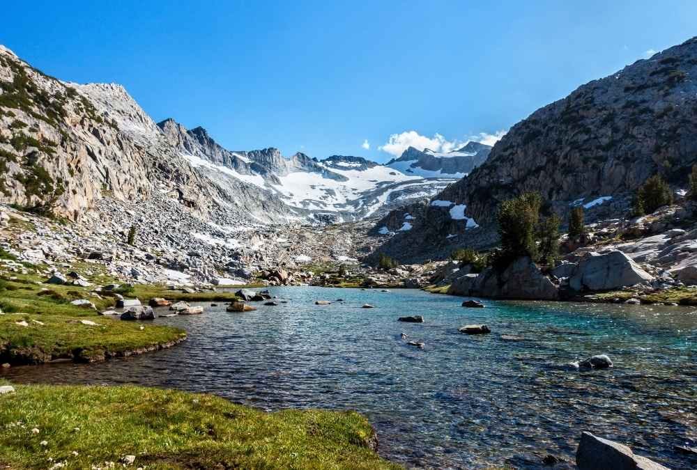
If you’re looking for a route that will test your endurance while immersing you in some of the most stunning mountain scenery in the country, the John Muir Trail (JMT) is the way to go. Running 211 miles through the heart of the Sierra Nevada, it traverses areas like Yosemite National Park, Kings Canyon, and Sequoia National Park. The trail is known for its rugged ascents, high-altitude passes, and jaw-dropping views, with several sections above 10,000 feet.
The JMT is unique because it’s a somewhat more attainable goal than the PCT, yet still offers a great challenge. The biggest hurdle is the elevation—climbing several high mountain passes, including the famous Forester Pass at 13,153 feet, which can feel like an obstacle course, especially if you’re not acclimated to the high altitude. Training beforehand for steep ascents and thin air is key, and you’ll want to be prepared for variable weather patterns.
Aside from the physical challenge, the JMT is a feast for the soul. The alpine lakes, glacial valleys, and towering granite peaks are otherworldly, and every step brings something new to see. Whether you’re walking through a misty morning in Yosemite or catching a sunset over the Kings Canyon ridges, it’s a trip that will leave you in awe of nature’s grandeur.
- Best Months to Visit: July to September (snow can linger in higher elevations until late June)
- Difficulty Level: Difficult, with a focus on elevation
- Elevation Gain: 46,000 feet+
- Total Length: 211 miles
- Key Gear: Lightweight gear, altitude sickness medicine, bear-proof containers
- Notable Highlights: Yosemite Valley, Mount Whitney, Sequoia National Park
3. Appalachian Trail (Georgia to Maine)
The Appalachian Trail (AT) is often the first serious long-distance trail that many backpackers take on. Spanning about 2,190 miles from Georgia to Maine, it’s a rite of passage for backpackers, and although not as grueling as the PCT, it still presents a serious challenge. The rugged terrain, unpredictable weather, and constant elevation changes are enough to push even the most seasoned hiker to their limits.
What makes the AT particularly tough is the varied terrain. From the rocky peaks of the Smoky Mountains to the rolling hills of Pennsylvania, it’s a constant cycle of ascents and descents. The infamous “rollercoaster” section in Virginia will have you feeling like you’re on a never-ending wave of mountains. And the unpredictable weather can catch you off guard—you might be sweating under the hot sun one minute and battling wind and rain the next. It’s a truly mental and physical test, especially if you decide to go for the full-thru-hike.
What I loved about the AT is the sense of community. Thru-hikers (or anyone walking it for an extended period) often form a bond that makes the journey a shared experience. Whether it’s trading stories at a shelter or laughing over a shared meal, the camaraderie adds an extra layer of enjoyment to the challenge.
- Best Months to Visit: Spring to early fall (April to October)
- Difficulty Level: Moderate to challenging (depends on the section)
- Elevation Gain: 330,000 feet+
- Total Length: 2,190 miles
- Key Gear: Waterproof boots, trekking poles, GPS, bug repellent
- Notable Highlights: Great Smoky Mountains, Mount Katahdin, Shenandoah National Park
4. The Enchantments (Washington)
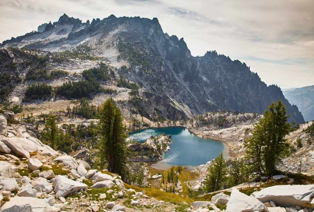
For those who want a remote, pristine alpine experience, the Enchantments in Washington’s Alpine Lakes Wilderness should be on your radar. This challenging 18-mile route is known for its spectacular beauty—think glacial lakes, snow-capped peaks, and alpine meadows. However, don’t let the length fool you; this trail is tough. The ascent up to Aasgard Pass, which sits at 7,800 feet, is a steep climb that requires careful navigation, especially in the winter months when the snow can linger.
What makes the Enchantments a challenge, however, is the elevation gain and the unpredictability of the weather. The trail offers very limited water sources in some sections, so staying hydrated is critical. Plus, it’s one of the few places where you can experience true wilderness with minimal human presence. That level of solitude is both liberating and daunting. I recall one evening camping by one of the lakes, feeling like the whole world was at rest, except for the faint rustle of wind and the calls of distant birds.
- Best Months to Visit: Late July to mid-September (snowpack still remains in early summer)
- Difficulty Level: Difficult, especially the ascent to Aasgard Pass
- Elevation Gain: 8,000 feet
- Total Length: 18 miles (if you complete the core route)
- Key Gear: Ice axe, crampons (if snow is present), sturdy hiking boots
- Notable Highlights: Snow Lake, Isolation Lake, Dragontail Peak
5. Teton Crest Trail (Wyoming)
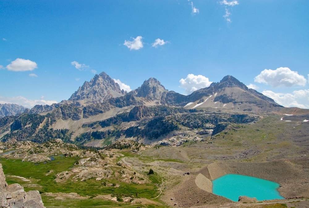
The Teton Crest Trail offers a spectacular and physically demanding hike through Wyoming’s Grand Teton National Park. Spanning 40 miles, it weaves its way through alpine meadows, jagged ridgelines, and deep valleys, all with the mighty Teton range towering in the background. What’s challenging about this trail is the steep ascents and descents that take you from valley floors to high alpine ridges. The high-altitude hiking (peaking at 10,000 feet) and the quick weather changes can be taxing on the body and mind.
Along the way, you’ll be rewarded with some of the most awe-inspiring views in the country—sweeping vistas of snow-capped peaks, lush meadows dotted with wildflowers, and pristine lakes that reflect the mountains in their crystal-clear waters. The trail also offers a few technical challenges, including navigating narrow ridgelines and descending boulder fields. It’s truly a trail for those looking for an adventure that will test both their stamina and their skills.
- Best Months to Visit: Late June to mid-September
- Difficulty Level: Challenging (due to elevation and rugged terrain)
- Elevation Gain: 10,000+ feet
- Total Length: 40 miles
- Key Gear: Bear-proof containers, trekking poles, sturdy boots
- Notable Highlights: Paintbrush Divide, Cascade Canyon, Jenny Lake
6. Zion’s Angels Landing (Utah)

The Angels Landing trail in Zion National Park is not for the faint-hearted. This 5.4-mile out-and-back hike is famous for its sheer drop-offs, narrow ridge walks, and stunning panoramic views of Zion Canyon. The steepness of the trail, combined with the high exposure, makes this one of the most thrilling yet nerve-wracking hikes in the U.S. The last half-mile, in particular, requires hikers to hold onto chains embedded into the rock to safely navigate the narrow ridge. It’s a serious test of both mental and physical endurance.
What makes the challenge even greater is the heat during the summer months and the limited shade on the trail, making hydration a top priority. In addition, falling rocks and occasional gusty winds can make the final ridge walk even more dangerous, so the right timing and preparation are essential for a safe experience. I remember being in awe of the view from the top but also having a little moment of fear looking down into the canyon below.
As nerve-wracking as it can be, there’s no denying that reaching the summit provides one of the most breathtaking vistas in the country. If you’re an adrenaline junkie, Angels Landing will be a hike you’ll never forget.
- Best Months to Visit: Spring to Fall (March to October)
- Difficulty Level: Very challenging (due to exposure and heights)
- Elevation Gain: 1,500 feet
- Total Length: 5.4 miles
- Key Gear: Trail shoes, plenty of water, gloves for the chain sections
- Notable Highlights: Zion Canyon, West Rim Trail, the final ridge walk
7. Mount Whitney Trail (California)
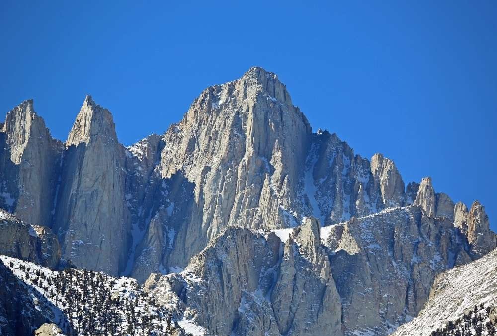
As the highest peak in the contiguous United States, Mount Whitney is a must-do for those seeking a serious challenge. The 11-mile trail leads to the summit at 14,505 feet, and it’s a demanding hike that requires stamina, preparation, and proper acclimatization. The thin air at high altitudes can make each step feel like a challenge, especially as you approach the summit. While the trail is technically a class 1 hike (non-technical), the elevation and distance add complexity.
The trial is not only physically demanding but also mentally taxing. The switchbacks near the top can feel endless, and the final summit push can be exhausting. Once at the top, though, the view is one of the most incredible rewards. You’ll have a panoramic view of the surrounding Sierra Nevada and the Owens Valley below. It’s a feeling of accomplishment like no other.
For a safe and successful summit, it’s important to spend a night or two acclimating to the higher elevations. With the proper preparation and mindset, conquering Mount Whitney will be a bucket-list achievement for any backpacker.
- Best Months to Visit: Late June to September (before snow begins)
- Difficulty Level: Challenging (due to altitude)
- Elevation Gain: 6,100 feet
- Total Length: 11 miles (one way)
- Key Gear: Layers (for cold winds), trekking poles, plenty of water
- Notable Highlights: Whitney Portal, Summit Views, East Face
8. Kings Canyon High Basin Route (California)

The Kings Canyon High Basin Route offers one of the most challenging backcountry routes in California’s Sequoia National Park. This route, which covers about 30 miles, takes you into the heart of the Sierra Nevada and demands both physical strength and technical skill. The trail doesn’t have a well-established path, so hikers need to be comfortable with off-trail navigation and be ready to boulder-hop, scramble, and handle steep inclines.
What makes this route particularly challenging is the remote nature of the hike. You’re not likely to encounter many people in this section, which is exactly what draws adventure seekers. The high-altitude environment means you’ll face exposure to the elements, rocky terrain, and the occasional snowfield. The hike is physically demanding, but if you can push through the rugged sections, you’ll be treated to secluded alpine lakes and towering granite peaks.
The sheer remoteness and ruggedness of the Kings Canyon High Basin Route make it a true test of your hiking and navigation abilities, perfect for those looking for a serious wilderness adventure.
- Best Months to Visit: Late July to September (when the snow has melted)
- Difficulty Level: Extremely challenging (due to off-trail sections)
- Elevation Gain: Over 6,000 feet
- Total Length: 30 miles
- Key Gear: Map and compass, rock climbing gloves, backcountry gear
- Notable Highlights: Upper Basin Lakes, Mount Tyndall, and Mount Williamson
9. Wind River Range (Wyoming)
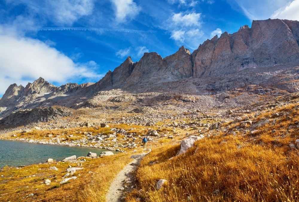
The Wind River Range is one of the hidden gems of the U.S. backcountry. Located in Wyoming, this range is known for its rugged, dramatic peaks and remote wilderness. The area offers several backpacking routes that vary in difficulty, but all of them involve significant elevation gain, challenging weather, and technical navigation. The Cirque of the Towers route is particularly famous for its rock climbing challenges, steep ascents, and jagged terrain, making it a haven for experienced backpackers looking to push themselves to the limit.
This range offers some of the wildest, most untouched scenery you’ll ever see—glacial lakes, towering granite spires, and pristine alpine meadows. It’s the kind of place that makes you feel truly removed from civilization. The combination of altitude, terrain, and remoteness means that you’ll need to be well-prepared, as weather can change rapidly and the rugged landscape requires careful navigation.
What makes the Wind River Range particularly special is that it’s much less traffic compared to other famous wilderness areas, so you’ll experience the solitude that many adventurers crave, making it a top pick for those looking to test their limits in the wild.
- Best Months to Visit: Late June to mid-September (snow can linger into July)
- Difficulty Level: Difficult (for experienced hikers)
- Elevation Gain: 10,000 feet+
- Total Length: Varies by route (up to 80 miles)
- Key Gear: Rock climbing gear, bear-resistant containers, waterproof gear
- Notable Highlights: Cirque of the Towers, Gannett Peak, Titcomb Basin
10. Highline Trail (Montana)
For those looking to challenge themselves in the Majestic Glacier National Park, the Highline Trail offers an unparalleled adventure. Spanning 15 miles, this trail runs along a narrow ledge with sweeping views of the park’s wild valleys and towering peaks. The challenge here comes not only from the distance and elevation gain but also from the high exposure on narrow cliffside paths that can feel precarious, especially in high winds.
Along the way, hikers will pass through wildflower-filled meadows, glacial lakes, and pristine forested areas. One of the highlights is the Garden Wall, a dramatic cliffside section where hikers will get views of both heavily glaciated peaks and the expansive valleys below. If you’re lucky, you might even spot some mountain goats navigating the steep terrain—reminding you just how rugged this environment can be.
It’s not just about the beauty; it’s about endurance. The high altitude, coupled with the fact that you’re hiking along exposed cliffs, makes the Highline Trail a serious test of mental fortitude.
- Best Months to Visit: July to September (before snow returns)
- Difficulty Level: Moderate to challenging (due to exposure and heights)
- Elevation Gain: 3,200 feet
- Total Length: 15 miles
- Key Gear: Hiking poles, trail shoes, bear spray
- Notable Highlights: Garden Wall, Granite Park Chalet, Swiftcurrent Pass
11. Lost Coast Trail (California)
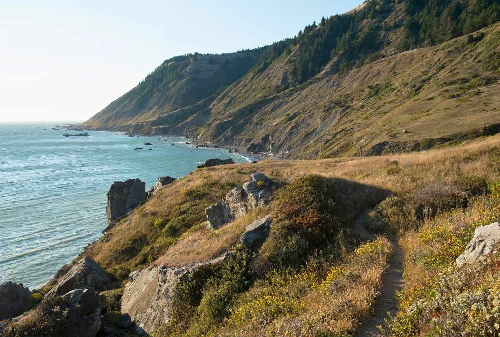
If you’re looking to completely disconnect from civilization and embrace true wilderness, the Lost Coast Trail is the answer. Located in California’s remote Humboldt County, this 25-mile coastal trail offers an experience that feels like stepping back in time. Unlike most coastal hikes, the Lost Coast is free of development, making it an incredibly raw and unspoiled environment. The rugged terrain, with its cliffs, wild river crossings, and unpredictable weather, presents a unique challenge for experienced hikers.
This trail is notorious for its isolated nature, meaning hikers need to be completely self-sufficient. You’ll need to carry all your supplies and be prepared for the unpredictable fog, rain, and wind that often roll in from the ocean. There’s a certain magic about being alone on a remote beach with towering cliffs to one side and crashing waves on the other. But let me tell you, navigation here can be tricky—getting lost in the fog is a real possibility, so good map reading skills and a sense of adventure are musts.
The challenge isn’t just physical; it’s the mental fortitude to face isolation and wilderness with no one around for miles. But if you’re willing to work for it, the sense of accomplishment is unparalleled.
- Best Months to Visit: April to October (weather is milder)
- Difficulty Level: Difficult (due to isolation and rugged terrain)
- Elevation Gain: 4,500 feet+
- Total Length: 25 miles
- Key Gear: Waterproof gear, GPS device, sturdy boots, and map
- Notable Highlights: Wild river crossings, remote beaches, rugged cliffs
12. South Boundary Trail (New Mexico)
For those seeking a more culturally rich yet physically demanding trail, the South Boundary Trail in New Mexico is an absolute standout. This 22-mile trek takes you through the stunning Santa Fe National Forest, offering dramatic views of the Sangre de Cristo Mountains and high desert landscapes. The trail is famous for its constant elevation changes, which can wear you down, but the reward is worth every step. This is a trail for the serious hiker who wants to combine challenging terrain with rich history and fascinating wildlife.
Expect to climb over several rugged ridges and traverse parts of the Sangre de Cristo Range, which can be quite grueling at higher altitudes. Rugged paths and the dry environment add to the challenge, and you’ll be walking through an environment where water sources are scarce, making careful planning essential. As you ascend, you’ll be rewarded with views of valleys and alpine lakes that make the sweat worth it. The high desert beauty here is mesmerizing, and the trail’s remoteness only adds to the allure.
The South Boundary Trail is not just about physical endurance; it’s a journey that allows you to experience New Mexico’s wild side. It’s a perfect mix of mental and physical testing wrapped in breathtaking landscapes.
- Best Months to Visit: Late spring to early fall (May to September)
- Difficulty Level: Challenging (due to elevation and terrain)
- Elevation Gain: 4,000 feet+
- Total Length: 22 miles
- Key Gear: Lightweight backpacking gear, water filter, hiking boots
- Notable Highlights: Sangre de Cristo Mountains, high desert views, alpine lakes
13. Lassen Volcanic National Park Trails (California)

Imagine walking across a landscape of volcanic peaks, bubbling sulfur springs, and steaming fumaroles—this is what you’ll get with the Lassen Volcanic National Park trails. The trail system in this park offers several challenging routes, but the Lassen Peak Trail is undoubtedly the most demanding and rewarding. With a distance of 5 miles round-trip and an elevation gain of over 2,000 feet, it’s a steep ascent to the top, but the views are worth it.
The volcanic activity adds an element of excitement to the hike, as you’re walking in an area of geothermal wonder. Along the way, you’ll encounter various geysers, boiling mud pots, and steam vents that remind you just how alive the Earth is beneath your feet. The challenge here lies in the steep sections, loose rock paths, and the thin air as you gain altitude. If you’re heading to the summit, bring plenty of water, and prepare to tackle windy ridgelines as you approach the peak.
One of the things that stood out to me was the sheer contrast of the landscape—from lush green meadows at the bottom to the volcanic rock near the top. It’s a powerful reminder of nature’s unpredictable forces.
- Best Months to Visit: June to September (snow can linger in higher elevations)
- Difficulty Level: Moderate to challenging (due to elevation and terrain)
- Elevation Gain: 2,000 feet+
- Total Length: 5 miles (round-trip)
- Key Gear: Sturdy hiking boots, sun protection, extra water
- Notable Highlights: Lassen Peak, geothermal features, sweeping views of the valley
14. Bright Angel Trail (Grand Canyon, Arizona)
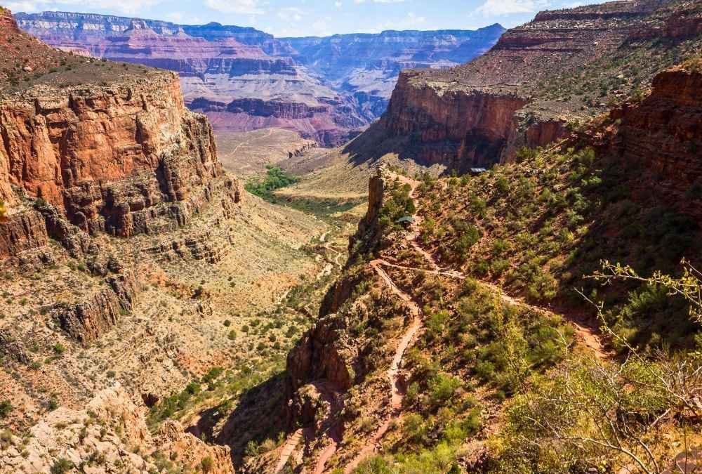
The Bright Angel Trail offers hikers one of the most iconic, yet physically demanding, challenges in the United States. Descending into the Grand Canyon is as tough as it sounds—the trail is steep, with switchbacks that drop 4,380 feet over 9.5 miles (one way). While it’s a popular trail due to its accessibility, don’t be fooled: hiking down into the canyon and then back up is a grueling task for most hikers.
The real challenge of the Bright Angel Trail comes when you begin the climb back up. The heat in the summer months can be brutal, and the altitude change makes it difficult for many hikers to maintain energy levels. However, the view from the bottom of the canyon, with the Colorado River flowing beneath towering cliffs, is unlike anything else in the world. Hiking this trail gives you a true sense of the vastness and immensity of the Grand Canyon, offering once-in-a-lifetime views.
One key takeaway from my hike: timing is everything. Starting early and bringing plenty of water is essential, as the canyon heat can drain you quickly. But even with the intense challenge, completing this trail feels like an accomplishment that’s hard to match.
- Best Months to Visit: Spring and fall (avoid summer due to heat)
- Difficulty Level: Challenging (due to elevation and heat)
- Elevation Gain: 4,380 feet
- Total Length: 9.5 miles (one way)
- Key Gear: Water, lightweight clothing, trekking poles
- Notable Highlights: Colorado River, Grand Canyon views, the descent and ascent
15. Grand Teton Summit Trail (Wyoming)

The Grand Teton Summit Trail offers adventurers a once-in-a-lifetime challenge. This technical climb to the summit of Grand Teton involves rock climbing, scrambling, and high-altitude navigation, making it ideal for those with mountain experience. At 13,775 feet, Grand Teton offers one of the most iconic summits in the U.S., with panoramic views of the Teton Range and surrounding valleys.
The summit approach isn’t for casual hikers; it requires technical climbing skills, proper gear, and knowledge of the route. The rocky terrain demands precision, while the altitude can leave you gasping for air. But for those who tackle the challenge, the summit offers a view that few have ever seen—majestic alpine lakes, endless ridgelines, and a sense of accomplishment you can’t get anywhere else.
The journey up Grand Teton is as much about mental strength as it is about physical ability. The rewards come not just from the summit but from the sheer beauty of the experience. Hiking here means pushing yourself to the limits, but the views make it all worth it.
- Best Months to Visit: June to September (snow can linger at higher elevations)
- Difficulty Level: Extremely challenging (requires technical skills)
- Elevation Gain: 7,000 feet+
- Total Length: Varies (12 miles for the full summit route)
- Key Gear: Rock climbing gear, crampons, high-altitude gear
- Notable Highlights: Grand Teton summit, Jenny Lake, Teton Range