Former Park Rangers Expose the 8 Secret Trails in America That Never Have Crowds: Experience Solitude Like Never Before
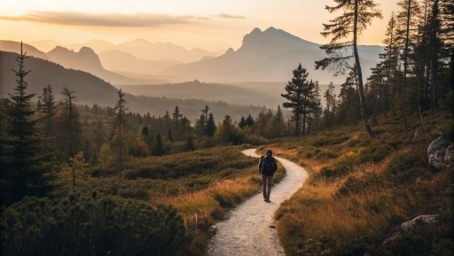
A quiet trail, where your footsteps are the only sound, offers something far beyond just a hike. It’s an invitation to slow down, to breathe in the fresh air, and to rediscover the beauty of a world unspoiled by the noise of everyday life. Imagine walking through a landscape where nature’s wonders unfold at your own pace, without the rush of others pushing through.
The trail becomes your own, each turn a new secret waiting to be uncovered, and every moment a chance to reconnect with something real and awe-inspiring. These hidden, lesser-known paths are far from the crowded tourist spots — they offer more than stunning views; they provide the solitude and tranquility we so often crave in a world that never stops moving. In these remote corners of the country, adventure waits for those willing to seek it out.
Ready to find out where the quiet trails lead? What’s ahead isn’t just an escape — it’s a trans-formative experience that only a few will ever get to have. Let’s uncover the gems you’ve been missing.
1. Highline Trail (via Logan Pass to The Loop), Glacier National Park, Montana
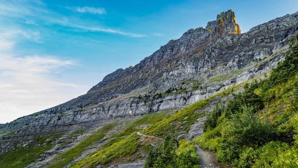
The Highline Trail is one of those trails that just keeps giving. Starting at Logan Pass — which sits at a lofty 6,646 feet — the trail stretches 11.6 miles and drops you into some of the most breathtaking views you’ll find in Montana. You’ll hike along the Garden Wall, a razor-thin ridge where the mountains seem to drop off into the abyss. The views are jaw-dropping, with peaks that seem to touch the sky and valleys carved by glaciers. You can spot mountain goats, bighorn sheep, and occasionally even grizzlies if you’re lucky. But here’s the kicker: while it’s one of the most beautiful hikes, it’s also one of the least crowded if you take it all the way to Granite Park Chalet, especially if you avoid the typical tourist spots.
The trail itself is considered moderately difficult. You’ll gain just 800 feet in elevation, but the descent can be steep — almost 3,000 feet by the time you reach The Loop. One of the best things about this trail is its accessibility. You can hike just a portion and turn around, or you can go the full distance. If you’re looking to really get away from the crowds, continue past the chalet toward the Swiftcurrent Pass Trail and you’ll find solitude and unbeatable views. The park’s wilderness opens up like a secret garden that only a few know about.
Key Practical Information
- Best season: Late June to September when the Going-to-the-Sun Road is open.
- Ideal duration: 5-7 hours for a one-way hike, or a full day if you want to explore further.
- Must-try local experiences: Stay at Granite Park Chalet for a night to fully immerse in the mountain experience.
- Photography opportunities: Sunrise and sunset provide stunning lighting on the Garden Wall.
- Budget considerations: There’s a park entrance fee, and if you opt for a shuttle back from The Loop, it’s free. Be sure to park early at Logan Pass.
- Cultural tips: Always carry bear spray, and stay on the marked trail to preserve the fragile alpine ecosystem.
2. Cascade Canyon Trail (via Jenny Lake Backside), Grand Teton National Park, Wyoming

You know that moment when you’re hiking and you feel like you’ve stepped into a postcard? That’s the vibe here on the Cascade Canyon Trail. Starting at Jenny Lake (a glacial lake nestled at the base of the towering Teton Range), this trail is a bit of a hidden gem. Most visitors only scratch the surface, hiking to the Hidden Falls or Inspiration Point. But if you keep going, the crowds thin out, and the canyon reveals its wild side. Cascade Canyon runs along a rushing stream, and as you head deeper into the valley, the landscape unfolds — vast meadows, dramatic cliffs, and a chance to spot moose and black bears in the wild.
What makes this hike even more special is that it feels like an adventure, but it’s still accessible for most skill levels. You’ll gain about 1,300 feet of elevation on a trail that’s 13.6 miles round-trip. The canyon is framed by jagged peaks, with stunning views of Mt. Owen and Grand Teton itself. If you make it all the way to Lake Solitude, you’re in for a rare treat — a peaceful alpine lake surrounded by towering peaks. Honestly, it’s one of those places that make you feel like you’re standing on top of the world, yet still so incredibly peaceful.
Key Practical Information
- Best season: Summer to early fall; avoid the summer crowds by hiking during weekdays.
- Ideal duration: 6-8 hours if you go all the way to Lake Solitude.
- Must-try local experiences: Take the shuttle across Jenny Lake to skip the busy lakefront and get into the wild faster.
- Photography opportunities: The falls and lake reflections make for incredible shots, especially during the early morning light.
- Budget considerations: Standard park entrance fee, plus a small fee for the boat shuttle across Jenny Lake.
- Cultural tips: The park is bear country, so carry bear spray and make noise as you hike.
3. Redwood Creek Trail (Gravel-Bar Route), Redwood National and State Parks, California

If you’ve ever wanted to walk through an ancient forest, the Redwood Creek Trail is your ticket. This trail takes you into the heart of California’s famed redwood groves, but here’s the thing — it’s one of the least crowded ways to experience the majesty of these towering trees. The trail stretches for 15.4 miles, with an elevation gain of about 1,100 feet, and it brings you through lush fern-filled canyons and across the gravel bars of Redwood Creek. While the park gets plenty of visitors, this trail still offers solitude, especially as you venture further away from the main trailheads.
What’s amazing about this trail is the sheer size of the trees. You’ll pass trees that are well over 300 feet tall, their trunks so wide you can’t even fathom how old they are. The creek winds through it all, and depending on the season, you might see salmon swimming upstream or be enveloped by the fog that gives the forest an almost mystical quality. For those looking to get away from the crowds, camping along Redwood Creek is a must-do. There are gravel bars where you can set up camp, and the forest is so quiet at night that you’ll forget there’s a world outside this majestic park.
Key Practical Information
- Best season: Spring through early fall, when creek levels are manageable for footbridges.
- Ideal duration: 6+ hours for a day hike, or 2 days if you want to do an overnight camp.
- Must-try local experiences: Camp along the creek at a gravel bar and listen to the forest come alive at night.
- Photography opportunities: Sunbeams filtering through the trees in the morning; fog rolling through the ancient forest.
- Budget considerations: Standard park entrance fee; free dispersed camping with a permit.
- Cultural tips: Follow Leave No Trace principles, as these are sensitive ecosystems.
4. North Fork Mountain Trail, Monongahela National Forest, West Virginia

This is the kind of hike that feels like it’s just for you — quiet, rugged, and full of hidden beauty. The North Fork Mountain Trail runs for about 25 miles along a ridge, offering stunning views of the Allegheny Mountains and the valleys below. It’s a relatively tough hike with plenty of elevation changes, but the payoff is big. The views stretch for miles, with steep cliffs and wildflower-covered meadows along the ridge. You’ll be hiking along a spine of the mountain, with cliffs on one side and thick forests on the other.
The area is a secret in its own right. Even though it’s in a popular national forest, you’ll often find stretches of the trail where you’re completely alone. This makes it a perfect escape if you’re looking for solitude. The flora here is unique, with red pine stands and alpine plant species rarely found in the region. It’s a hidden gem for anyone looking to escape into nature. If you can, hike to Chimney Top, a stunning overlook where the valley opens up beneath you. The views are dramatic and worth the effort.
Key Practical Information
- Best season: Spring through fall, with autumn providing spectacular foliage.
- Ideal duration: For the Chimney Top section, 3-4 hours. The full ridge hike takes a day or more.
- Must-try local experiences: Reach the Chimney Top overlook and take in the vast views.
- Photography opportunities: Early morning shots of mist hanging in the valleys; golden hour lighting on the ridge.
- Budget considerations: Free access, but parking is limited, so plan to arrive early.
- Cultural tips: Keep an eye on weather changes, as the ridge can get unexpectedly windy and cold.
5. Bull of the Woods – Mountain Meadows Loop, Mount Hood National Forest, Oregon

This trail is tucked into the Mount Hood Wilderness area and feels like an insider’s secret. The loop itself covers about 7.1 miles with an elevation gain of 2,050 feet. It’s an approachable hike with incredible scenery — from wildflower meadows to dense forests, all set against the backdrop of Oregon’s majestic Cascade Range. You’ll catch views of Mt. Hood, Mt. Jefferson, and even glimpses of the distant Columbia River Gorge. The trail weaves through alpine lakes and old-growth forests, making it feel like you’ve stepped into another world.
What makes it feel so secret is the lack of crowds. This is a relatively quiet trail compared to some of the more famous hikes in Oregon. The Bull of the Woods lookout offers 360-degree views of the Cascade peaks, and Pansy Lake is a serene spot to relax. If you’re into wilderness experiences but don’t want to deal with large crowds, this trail is a great option. The meadows in summer are especially stunning, with vibrant wildflowers filling the landscape.
Key Practical Information
- Best season: Summer to early fall, when the snow is gone and trails are dry.
- Ideal duration: 4-6 hours for the loop, but longer if you venture into the backcountry.
- Must-try local experiences: Summit the Bull of the Woods lookout for incredible panoramic views.
- Photography opportunities: Capture wildflowers, alpine lakes, and views of Mt. Hood.
- Budget considerations: Free trail access; some backcountry permits may be required.
- Cultural tips: Be mindful of wilderness regulations, including Leave No Trace and wildlife safety.
6. Lost Mine–Cañoncito Connector, Big Bend National Park, Texas

There’s something magical about Big Bend — it’s a place where the desert meets the mountains in a way that feels like an ancient secret only a few know about. The Lost Mine Trail is popular, but if you venture onto the Cañoncito Connector, you’re in for an unexpected journey. Starting from the Chisos Basin, this connector trail takes you into a quieter part of the park where towering rock formations, lush canyons, and the vast, open desert are yours to explore. Imagine walking through an old, sun-dappled canyon, surrounded by walls of rugged stone, while the distant call of a bird echoes through the air.
The Cañoncito Connector is a hidden gem that blends the best of both worlds. As you trek through, you’ll be surrounded by solitude, with only the occasional sight of a bighorn sheep or a hawk soaring overhead. This trail offers a unique view of the Chisos Mountains from a more secluded vantage point. If you keep your eyes peeled, you’ll find wildflowers sprouting in the cracks of the desert landscape — a quiet reminder that life finds a way in the harshest environments.
Insider Tips
- Timing is everything: If you’re looking to really experience peace and quiet, hit this trail early in the morning or late in the afternoon when the crowds are thin.
- What to bring: Pack plenty of water — Big Bend’s desert climate is unforgiving, and the heat can be intense, especially in the summer months.
- Unique perspective: Take a moment at the top of the trail to look out across the valley below. The view of the Rio Grande River winding through the desert is unlike anything you’ll see elsewhere.
Practical Info
- Distance: The Cañoncito Connector is roughly 5.6 miles one-way.
- Duration: Expect around 4-5 hours for a round trip.
- Season: Fall to spring is ideal, as summer heat can be oppressive.
- Photography Opportunities: Capture the interplay of light and shadow in the canyon, especially at sunset when the colors pop.
- Bear in mind: Cell service is spotty, so have a map and compass. And be sure to follow Leave No Trace principles.
7. Lakeshore–Moskey Basin Connector, Isle Royale National Park, Michigan
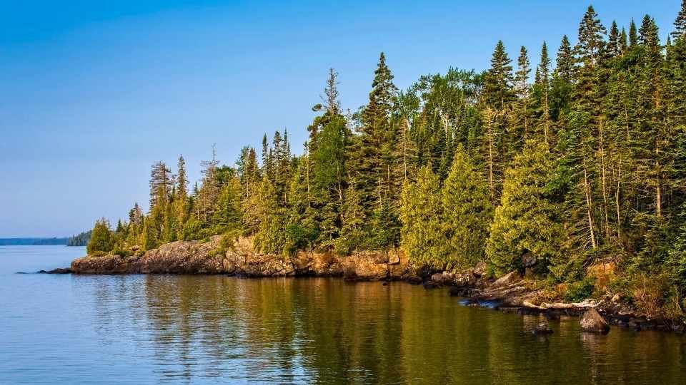
If you’ve ever dreamt of escaping the world for a while, the Lakeshore–Moskey Basin Connector offers an almost otherworldly experience. Isle Royale, located in the remote waters of Lake Superior, is one of the least-visited national parks in the U.S., and the Lakeshore–Moskey Basin trail feels like it’s tucked away from the world. The trail stretches about 8.1 miles round-trip, but the journey offers much more than just a scenic hike. You’ll pass through dense forests, alongside shimmering lakes, and find yourself at secluded beaches where the sounds of the world seem to fade away.
What makes this trail stand out isn’t just the natural beauty; it’s the sheer isolation. As you make your way through dense forests of birch and cedar, you’ll encounter only the occasional backpacker or a family of otters playing by the shore. The Moskey Basin itself is serene, with calm waters reflecting the surrounding trees and rocky shores. Imagine finding a quiet spot on the beach to sit, letting the cool breeze of Lake Superior sweep through your hair, while the stillness of the water makes everything feel timeless.
Insider Tips
- Go off-season: Isle Royale is less crowded in early spring and late fall, making it the perfect time to experience solitude.
- What to bring: Bug spray! The mosquitos can be a nuisance during the summer, especially near the water.
- Unique perspective: Take a moment to hike up to the Moskey Basin Overlook for panoramic views of the bay, framed by the jagged shoreline.
Practical Info
- Distance: 8.1 miles (round-trip)
- Duration: Plan for 4-5 hours of hiking, plus extra time if you decide to stop and enjoy the beach or do some wildlife spotting.
- Season: Best from mid-June to mid-September, as the park is mostly inaccessible outside this window due to ferry schedules and weather conditions.
- Photography Opportunities: Sunrise over the lakeshore; reflections on the calm waters; wildlife in the forest.
- Cultural tips: Isle Royale has a rich history of Native American heritage and early explorers — take a guided tour or read up on the park’s history to enhance your visit.
8. South Rim – Shoshone Point Approach, Grand Canyon National Park, Arizona

Grand Canyon National Park is undoubtedly one of the most visited places in America, but hidden in plain sight is Shoshone Point, a lesser-known spot along the South Rim that offers a unique, almost private view of the canyon. Most visitors flock to the major viewpoints, like Mather Point and Yavapai Observation Station, but Shoshone Point feels more like an insider’s secret. It’s only a short, easy walk from the parking lot, but the reward is immense. The view from Shoshone Point is like something straight out of a painting — you get a sweeping panorama of the canyon, with the Colorado River weaving through the jagged rocks far below. And here’s the kicker: because it’s tucked away at the end of a small road, you’ll often find yourself alone or with just a handful of people, allowing for quiet reflection and stunning photographs without the crowds.
The beauty of Shoshone Point isn’t just in the view. It’s in the way the light changes throughout the day — at sunrise, the canyon lights up with hues of orange and pink, while sunset turns the landscape into a golden, ethereal world. This point is also where many visitors discover the Grand Canyon from a fresh angle, one that captures the true size and depth of the canyon in a way the more crowded spots can’t.
Insider Tips
- Best time to visit: Sunrise or sunset for the most dramatic light, and fewer crowds.
- What to bring: A picnic! There’s something magical about sitting on a bench at Shoshone Point, taking in the views with a snack in hand.
- Unique perspective: If you can, go during the off-season (fall or early spring), when the park’s quieter and you get a more peaceful experience.
Practical Info
- Distance: About a half-mile from the parking area, with minimal elevation gain.
- Duration: Less than an hour for a visit, but plan to linger and take in the views.
- Season: Best in spring and fall; summer can be extremely hot, and winter might bring snow and ice, though the crowds will be thinner.
- Photography Opportunities: Capture the dramatic canyon views, especially during the golden hour. The lighting here is unreal!
- Cultural tips: This spot is also culturally significant to Native American tribes, so be respectful and mindful of the land.