The freedom of hitting the road with your home on wheels — waking up to epic views right by your windows, where nowhere you have to be is a legitimate thing. It is that sort of adventure that nourishes the soul, every corner a different tale that time and nature have etched.
Are you one of those who fondly recall planning to pull over and just stay in your RV for free among the epic scenery, omens, and history whispers from mountains high?
Follow on to be surprised with the most hidden, beautiful back road routes where your ride and campsite melt into an unforgettable destination.
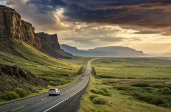
1. Scenic Byway 12, Utah (Near Grand Staircase-Escalante & Bryce Canyon)

The ‘Scenic Byway’ 12″ is no drive through Utah, it stops you in your tracks. The 122-mile drive from Capitol Reef to Bryce Canyon NP follows some of the best red rock canyons, slickrock ridges, alpine forests, and moonscape plateaus in a 100-mile slice of Utah! Yes, there are legally roadable BLM areas for boondocking, especially near the Grand Staircase-Escalante National Monument in Utah you can find the best off-grid spots. Escalante pull-offs and dirt roads are defined as the most popular spots for experienced RVers who know how to grab last last-minute desert off-grid view.
Escalante’s endless canyon layers are the thing that is surreal when waking up to. Intentionally dispersed campsites with Hole-in-the-Rock Road and Hell’s Backbone keep you equally distanced from your car or the views. You would wake to the cawing of ravens, hungover, and a view that defies capturing digitally.
This route is especially appealing because it packs so many landmarks into a relatively short drive. In one day, you can go from desert bluffs to alpine meadows, all while parked in places you don’t have to pay for. Cell service is spotty, which can be either a blessing or a curse depending on your needs, but you won’t regret being unplugged out here.
Quick Guide:
- Best Months to Visit: Late April to early June, September to mid-October
- Elevation: 5,000–9,000 ft – expect chilly nights even in summer
- Legal Camping Zones: BLM land along Hole-in-the-Rock Rd, Cottonwood Canyon Rd
- Nearest Services: Escalante, UT (propane, dump station, groceries)
- RV Tips: 4WD helpful for deeper spots, but many gravel pullouts are big rig friendly
2. Blue Ridge Parkway, Virginia & North Carolina (Near Stone Mountain & Mount Mitchell)

Winding through the Appalachian Highlands, the Blue Ridge Parkway is a legendary road trip route for a reason. RVers can legally park for free along certain national forest roads adjacent to the Parkway, especially near Mount Mitchell State Park and Stone Mountain State Park, which border national monument territory. While there are no pull-over boondocking spots right on the Parkway, the adjacent Pisgah and Jefferson National Forests offer plenty of options.
The Blue Ridge has a nice romantic feel, especially in the morning while that fog is rolling over the ridges. For green drivers who love waterfalls and wildflowers, this is the ultimate drive you have been seeking. And all this for no parking money in the area overnight.
The Parkway’s driving speed is slow (often under 45 mph), which adds to its charm. With frequent overlooks, historic cabins, and tunnels cut straight through the rock, you’re not in a rush here, and that’s the point. Pull off onto a forest road in the evening, make camp, and let the mountain silence wrap around you.
Quick Guide:
- Best Months to Visit: May–June for wildflowers, October for fall foliage
- Elevation: 600 to over 6,000 ft – can get cool quickly
- Legal Camping Zones: Pisgah NF (NC), George Washington & Jefferson NF (VA)
- Nearest Services: Asheville, NC, and Roanoke, VA
- RV Tips: Smaller RVs are better for switchbacks; watch tunnel heights
3. Natchez Trace Parkway, Tennessee to Mississippi (Near Emerald Mound & Tupelo National Battlefield)

If slow and serene is your style, Natchez Trace Parkway is tailor-made. This 444-mile route is steeped in history, following an old Native American trade route. While it doesn’t have the dramatic scenery of Utah or Colorado, it offers a calming, green corridor with plenty of pull-offs and free camping at designated Parkway campgrounds—yes, real campsites that are 100% free and legal.
The stretch near Emerald Mound, one of the largest Native American mounds in the U.S., is particularly compelling. RV travelers often stay at the Jeff Busby or Rocky Springs campgrounds—simple but shaded spots where you can cook over a fire and listen to the cicadas.
Unlike many other routes, Natchez Trace is ideal for longer stays. It’s less about iconic landscapes and more about unplugging and decompressing. You’ll share the road with cyclists, classic car caravans, and maybe even a group of deer crossing at dawn. It’s one of those places that sneaks up on you and stays with you.
Quick Guide:
- Best Months to Visit: March–May for wildflowers, October for leaf color
- Elevation: Mostly low rolling hills
- Legal Camping Zones: Jeff Busby, Rocky Springs, Meriwether Lewis (all free)
- Nearest Services: Tupelo, MS; Jackson, MS
- RV Tips: No commercial traffic; ideal for big rigs and towables
4. Sheep Bridge Road, Utah (Near Zion National Park & Cedar Breaks National Monument)

For a rugged but rewarding experience, Sheep Bridge Road—a dirt road just outside Zion National Park—offers free BLM boondocking with mountain views. This is one of the few places where you can wake up and drive into Zion within 20 minutes, without ever touching a campground reservation.
The road is well-maintained early on and accessible to most RVs, though the deeper you go, the rougher it gets. The early sites are flat, spacious, and shaded by juniper trees, with just enough cell service to check a map. Nights here are impossibly quiet, and stargazing is otherworldly.
Many RVers use this as a base for exploring not only Zion, but also Cedar Breaks National Monument, which is about an hour north and offers alpine views and volcanic formations. You get the best of southern Utah here—red rock desert by day, cool mountain air by night—without the crowds or the campground fees.
Quick Guide:
- Best Months to Visit: April–June, September–October
- Elevation: ~4,500 ft – warm days, cool nights
- Legal Camping Zones: Along Sheep Bridge Road (BLM land)
- Nearest Services: Hurricane, UT
- RV Tips: Arrive early for the best spots, especially on weekends
5. Buffalo Gap National Grassland, South Dakota (Near Badlands National Park)

For dramatic landscapes and legal, free camping with million-dollar views, Buffalo Gap National Grassland is hard to top. Located just outside Badlands National Park, this area allows dispersed camping right on the rim of the Badlands, with no permits no fees. You’ll find established pull-offs where RVers respectfully share space, and the sunsets over the striped cliffs are unforgettable.
The contrast of prairie grasslands meeting jagged rock formations makes this location truly unique. It’s not just a great overnight spot—it’s a destination. With the national park just minutes away, and Wall Drug (yes, that iconic stop) nearby for kitschy fun and essentials, you’ve got both wilderness and convenience.
Even if you’re new to boondocking, this is a great place to start. The roads are mostly gravel and flat, and the wide-open views mean you won’t feel boxed in. Just make sure you’ve got solid tire pressure—the grassland can be deceiving when wet.
Quick Guide:
- Best Months to Visit: May–June, September
- Elevation: ~2,400 ft – moderate climate
- Legal Camping Zones: South Rim Road, Sage Creek area (BLM)
- Nearest Services: Wall, SD
- RV Tips: Winds can be fierce—use leveling blocks and stabilize well
6. Valley of the Gods Road, Utah (Near Natural Bridges & Bears Ears National Monument)

In the southeastern corner of Utah, Valley of the Gods Road digs to a miniature Monument Valley minus the price, volume, and peskiest regulations at the boundary. Drives 17 miles of exposed desert, exposed rock forms here and there in sandstone towers or mushroom rocks. If you follow that well-maintained road managed by the BLM, it is BOONDOCKING LEGAL and FREE all the way!
What’s magical here is the silence. Your RV will park with the backdrop of rock spires that dance in a myriad of colors with the shift of light. It is one of the darkest skies in the country at night; an ideal choice for stargazing or astrophotography. Natural Bridges National Monument— natural arches made from stone, an hour away. Natural Bridges is one of the most culturally rich landscapes in the Southwest, and you can be there in less than an hour.
The road is generally passable by most RVs in dry weather, though a sudden rainstorm can make it impassable quickly. This is classic high desert camping: no hookups, no cell service in some spots, and all the space in the world.
Quick Guide:
- Best Months to Visit: April–May, September–October
- Elevation: ~4,500 ft – warm days, cool nights
- Legal Camping Zones: Anywhere along the Valley of the Gods Road (BLM)
- Nearest Services: Bluff, UT, and Mexican Hat, UT
- RV Tips: Avoid after rain; ideal for self-contained rigs
7. Stanley Lake, Idaho (Near Sawtooth National Forest & National Recreation Area)

Craving alpine scenery with that high-elevation chill? Stanley Lake, near the Sawtooth National Recreation Area, offers a slice of the Rockies that’s surprisingly accessible and boondocking-friendly. While the formal campground requires a fee, RVers in the know head just past it, where free dispersed camping is allowed with million-dollar views of jagged peaks.
This is a lake you’ll want to stay at for days. Clear water, pine forests, and the dramatic rise of the Sawtooths make it feel like a national park—but without the crowds. Hiking, kayaking, and mountain biking trails are just steps from your rig. Sunrises over the lake? Unreal.
Though you’re only about 15 minutes from the tiny town of Stanley, this still feels like remote wilderness. Elk sometimes roam nearby, and early mornings are filled with bird calls and the faint gurgle of snowmelt streams.
Quick Guide:
- Best Months to Visit: Late June to early September
- Elevation: ~6,500 ft – chilly nights year-round
- Legal Camping Zones: Forest roads around Stanley Lake (NF land)
- Nearest Services: Stanley, ID (tiny but RV-friendly)
- RV Tips: Mosquitoes in early summer; bring a solar or generator
8. Skyline Drive, Virginia (Near Shenandoah National Park & Appalachian Trail Access)

Part of Shenandoah National Park, Skyline Drive offers one of the East Coast’s most iconic mountain drives. And while camping directly on the Drive isn’t free, you’ll find legal dispersed camping on nearby George Washington and Jefferson National Forest lands, often within 10–15 minutes of park entrances. These forest roads are quiet, wooded, and legally open to RVs (with no fees).
Skyline Drive itself is a wonder, winding through 75 overlooks across 105 miles, all with views of the Blue Ridge Mountains. When you step out of your RV near a misty forest trail or creekside nook, it feels a world away from civilization.
You can easily base yourself in one of the NF pullouts, then drive the Parkway during the day. It’s especially gorgeous during fall, when the foliage explodes into color, and wildlife (especially black bears and deer) are out and about.
Quick Guide:
- Best Months to Visit: May–June, late September–October
- Elevation: ~2,000–4,000 ft
- Legal Camping Zones: GW & Jefferson NF – forest roads off Routes 33, 211
- Nearest Services: Luray and Front Royal, VA
- RV Tips: Small to mid-size RVs are ideal; bear-proof your trash
9. Peter Norbeck Scenic Byway, South Dakota (Near Mount Rushmore & Jewel Cave)

The Peter Norbeck Scenic Byway is found rarely where you can see native architecture and wild places in a few miles, like at the Peter Norbeck Scenic Byway. The rack pulls you through Custer State Park and Black Hills National Forest, delivering many miles of legal dispersed camping on NPS-administered lands (national forest lands), fewer than minutes from big-time names such as Mount Rushmore and Jewel Cave National Monument.
This byway is famous for its twisty tunnels carved through granite, bison herds roaming roadside meadows, and granite spires that rise straight out of the pines. As you cruise past Sylvan Lake or the Needles Highway, it’s hard not to stop every five minutes.
The dispersed camping areas—especially off Iron Mountain Road and Forest Road 330—are shady, scenic, and blissfully quiet at night. And you’re not far from quirky towns like Keystone or Custer, which are perfect for restocking and a bit of old-west flavor.
Quick Guide:
- Best Months to Visit: Late May–September
- Elevation: ~5,000–6,500 ft – warm days, crisp nights
- Legal Camping Zones: Black Hills NF off Iron Mtn Rd, FR 330, Castle Creek
- Nearest Services: Custer and Keystone, SD
- RV Tips: Watch for low tunnels; route better for <35 ft rigs
10. Rim Drive, Oregon (Near Crater Lake National Park)

Rim Drive loops around one of the most mesmerizing natural landmarks in the U.S.—Crater Lake, the deepest lake in the country. While you can’t legally camp inside the park for free, nearby U.S. Forest Service roads allow dispersed RV camping—all within 10 to 15 minutes of park entrances.
Once inside the park, the drive around the caldera gives you endless viewpoints of that impossibly blue lake. Outside the park, quiet forest pullouts along roads like NF-3651 and NF-600 are your go-to. These are legal, level spots nestled among towering pines.
This area is ideal for self-contained rigs that want the national park experience without the fees or reservations. Come early in the season for snow-capped views—or in September for golden light and fewer tourists.
Quick Guide:
- Best Months to Visit: July–early October (snow closes Rim Drive most of the year)
- Elevation: ~6,000–7,100 ft – pack for sudden cold snaps
- Legal Camping Zones: Fremont-Winema NF off Hwy 62 and forest spurs
- Nearest Services: Prospect and Fort Klamath, OR
- RV Tips: Check snow conditions; no hookups or services nearby
11. El Malpais Scenic Byway, New Mexico (Near El Malpais National Monument & El Morro National Monument)

New Mexico’s high desert has something unmistakably alien about it, and the El Malpais Scenic Byway perfectly expresses the vibe. This lesser-known route off I-40 near Grants winds past lava fields, sandstone bluffs, ancient lava tubes, and dramatic sky mesas. Best of all, it cuts directly between El Malpais and El Morro National Monuments, with ample free dispersed camping on surrounding BLM and national forest lands.
You’re not just camping out here on the calendar—you are time surfing. The Spanish El Malpais literally translates to “the badlands,” and the land feels truly ancient. You’ll pass rugged volcanic fields and trails used by Indigenous people for centuries. A short detour puts you in El Morro, where Spanish conquistadors and ancestral Puebloans carved their names into a sandstone wall over hundreds of years. It’s history you can touch—and sleep beside, for free.
RVers will appreciate how easy it is to find solitude out here. Whether you prefer wide-open gravel pull-offs or tucked-away forested spots in the Cibola National Forest, you’ll be able to park without a fee or a neighbor in sight. Bonus: the stargazing is top-tier, thanks to the low light pollution.
Quick Guide:
- Best Months to Visit: March–May, September–early November
- Elevation: ~6,500–7,200 ft – cold nights year-round
- Legal Camping Zones: BLM lands off Highway 117, Forest Road 42
- Nearest Services: Grants, NM
- RV Tips: Roads can be rough in places—keep a shovel and traction boards handy
12. Pacific Coast Highway (Hwy 1), California (Near Point Reyes National Seashore & Fort Ord National Monument)

The Pacific Coast Highway needs no introduction—but many RV travelers don’t realize that there are legal, free camping opportunities along or just inland from this iconic road, particularly near the Point Reyes National Seashore and Fort Ord National Monument. You’re not boondocking on the cliffs (unfortunately), but if you know where to look, you can camp affordably—and legally—within striking distance of the ocean.
Take, for instance, the Cowell Ranch and Los Padres National Forest areas. Inland forest roads near Big Sur and Monterey offer peaceful dispersed camping under redwoods or coastal pines, where the salt air still drifts through at dawn. Fort Ord, just outside Monterey, offers hiking and biking trails galore, and the views along Hwy 1 are unmatched.
Here’s the beauty of this route: you can wake up inland among trees, drive 20 minutes, and be eating chowder with a view of the Pacific. RVers who chase coastal beauty without the KOA prices will find this stretch of California rewarding, especially if you don’t mind a little extra scouting to find those sweet, legal spots.
Quick Guide:
- Best Months to Visit: April–June for wildflowers, September–October for calm weather
- Elevation: Sea level to 1,500 ft, depending on location
- Legal Camping Zones: Los Padres NF roads near Big Sur, Cowell Ranch State Beac,h inland areas
- Nearest Services: Monterey, ,CA and Half Moon Bay, CA
- RV Tips: Limited size access on Hwy 1—under 30 ft is safest; foggy mornings common