There’s something primal and electrifying about standing on the edge of a volcano—the sheer power beneath your feet, the ancient forces that shaped the land, the raw beauty of a world forged in fire.
These hikes aren’t just trails; they’re journeys through time, where lava flows whisper stories of past eruptions, and towering craters remind you that the Earth is alive and restless.
Some are rugged, demanding every ounce of endurance, while others let you walk with ease across surreal landscapes. Each one promises an experience that’s unforgettable, humbling, and thrilling—are you ready to explore the fire beneath your feet?
1. Mount St. Helens, Washington
Mount St. Helens is not just a hike—it’s a journey through one of the most explosive events in U.S. history. When this volcano erupted in 1980, it drastically reshaped the landscape, leaving behind a vast crater, barren lands, and a surreal terrain that feels like another planet. Today, hikers can experience this ever-changing environment firsthand, making the trek up to the summit one of the most rewarding volcano hikes in the country.
The Monitor Ridge route, the most popular path, is a tough but exhilarating climb, taking you over volcanic boulders, loose ash, and ridges with sweeping views of Spirit Lake and the surrounding Cascade Mountains. As you ascend, you’ll witness the stark contrast between the lush forests below and the lunar-like summit, where the scars of the eruption remain. The real reward? Reaching the crater’s rim and peering down into the smoking heart of the volcano, a reminder that this sleeping giant is still very much alive.
Hiking Mount St. Helens is an adventure that requires preparation. The loose ash and exposed terrain make it a physically demanding hike, but the experience is unforgettable. Whether it’s the thrill of standing on an active volcano or the eerie beauty of the blast zone, every step feels like walking through history.
- Best Months to Visit: July – October (Snow-free months with clearer skies)
- Difficulty Level: Challenging (Steep, with loose ash and rock scrambling)
- Permit Required? Yes, a permit is required year-round for summit hikes.
- Trail Length & Time: 9 miles round trip, ~7-10 hours
- Highlight: The view into the crater and the sense of geological history beneath your feet
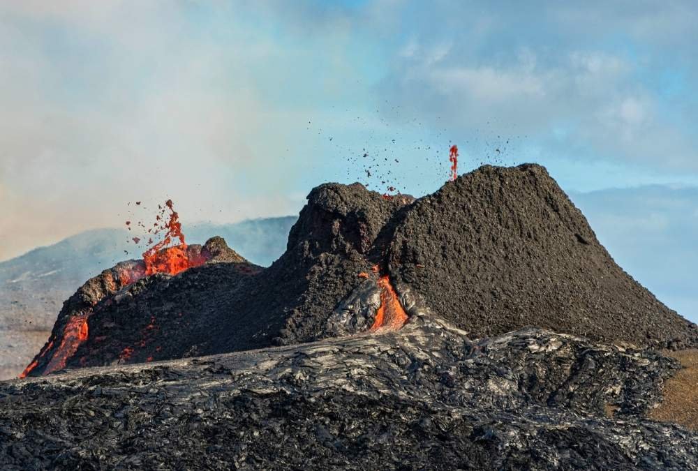
2. Kīlauea, Hawaii
Kīlauea isn’t just a hike—it’s a living, breathing volcano. Unlike most others on this list, Kīlauea is one of the most active volcanoes on Earth, with its landscape constantly shifting due to lava flows. The surreal feeling of walking across freshly cooled lava, where heat still radiates beneath your boots, is something you won’t forget.
One of the best hikes here is the Kīlauea Iki Trail, a 4-mile loop that takes you from a lush rainforest down into a massive crater formed by an eruption in 1959. Along the way, you’ll walk across hardened lava lakes, see steam vents, and get up close to the raw power of nature. If you want to witness actual lava (conditions permitting), a trek along the Pu’u Ō’ō Trail or Chain of Craters Road offers a chance to see molten rock flowing into the ocean—one of the most mesmerizing sights on Earth.
The experience of hiking Kīlauea is like stepping into a primal world. It’s both humbling and exhilarating to be surrounded by an environment that’s constantly being reshaped by fire and earth. Unlike dormant volcanoes, Kīlauea reminds you that the planet is alive and evolving right beneath your feet.
- Best Months to Visit: Year-round, but May – September offers drier conditions.
- Difficulty Level: Moderate (Varies by trail, but terrain can be rugged)
- Permit Required? Not usually, but check lava flow areas for restrictions.
- Trail Length & Time: Varies (~4-12 miles depending on the route)
- Highlight: Walking across a lava field and possibly seeing active lava flow
3. Mount Rainier, Washington
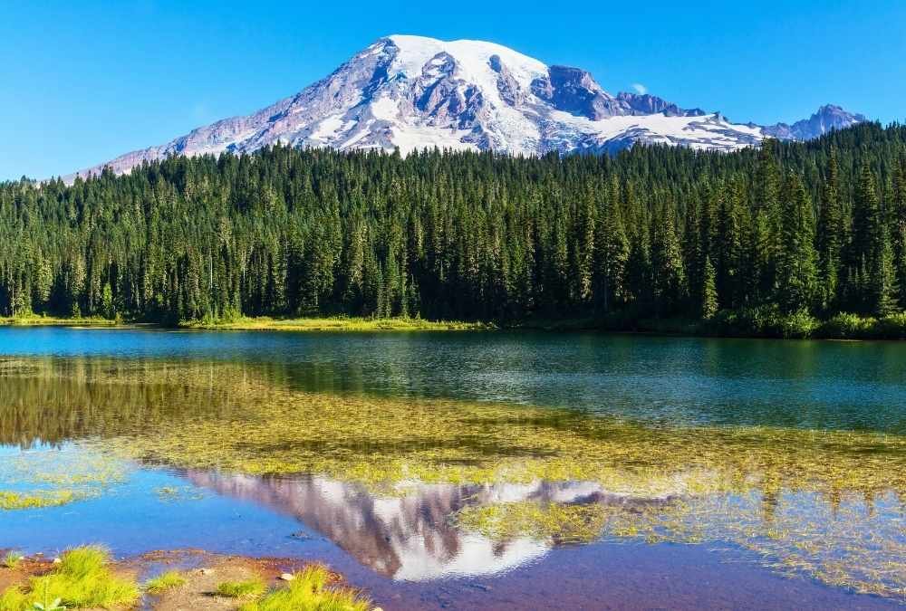
Towering at 14,410 feet, Mount Rainier dominates the Seattle skyline and is one of the most iconic volcanoes in the U.S. While summiting Rainier is a serious mountaineering feat, there are plenty of accessible hikes that let you experience its glaciers, meadows, and dramatic landscapes without technical climbing.
The Skyline Trail in Paradise is one of the best hikes for those who want a taste of Rainier’s beauty. This 5.5-mile loop takes you through wildflower-filled meadows, waterfalls, and panoramic mountain views that look straight out of a painting. On clear days, you’ll see neighboring peaks like Mount St. Helens and Mount Adams. If you’re up for a bit more challenge, the Camp Muir route (9 miles round trip) takes you to a high-altitude base camp, giving you a sense of what climbers experience on their way to the summit.
Hiking Rainier is breathtaking—literally and figuratively. The high elevation means you’ll feel the thin air, but it’s all worth it when you stand among glaciers and alpine views that make you feel on top of the world.
- Best Months to Visit: July – September (Wildflowers bloom in July/August)
- Difficulty Level: Moderate to Difficult (Depends on the trail)
- Permit Required? No for day hikes, Yes for overnight and summit climbs
- Trail Length & Time: Varies (~5-9 miles for most scenic day hikes)
- Highlight: Expansive glacier views and stunning wildflower meadows
4. Lassen Peak, California
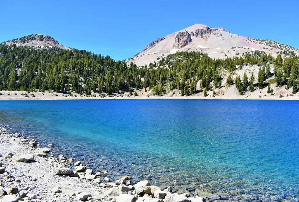
Lassen Peak is one of the best-kept secrets among U.S. volcano hikes. This dormant but not dead volcano last erupted in 1915, and its rugged landscape is a mix of steaming fumaroles, bubbling mud pots, and epic summit views.
The hike to the top is only 5 miles round trip, but don’t let the short distance fool you—it’s a steep climb. The well-maintained trail zigzags up the rocky slopes, offering constant views of the Lassen Volcanic National Park’s surreal terrain. On clear days, you can even spot Mount Shasta in the distance. The summit itself gives you a 360-degree view of surrounding peaks and the vast California wilderness.
What makes Lassen unique is its geothermal activity. Before or after your hike, check out Bumpass Hell, a geothermal area filled with steaming vents, bubbling pools, and the scent of sulfur in the air. It’s a reminder that this volcano is still alive beneath the surface.
- Best Months to Visit: July – October (Snow lingers into early summer)
- Difficulty Level: Moderate to Strenuous (Steep, but short)
- Permit Required? No
- Trail Length & Time: 5 miles round trip, ~3-5 hours
- Highlight: Summit views and unique geothermal features in the park
5. Mount Hood, Oregon
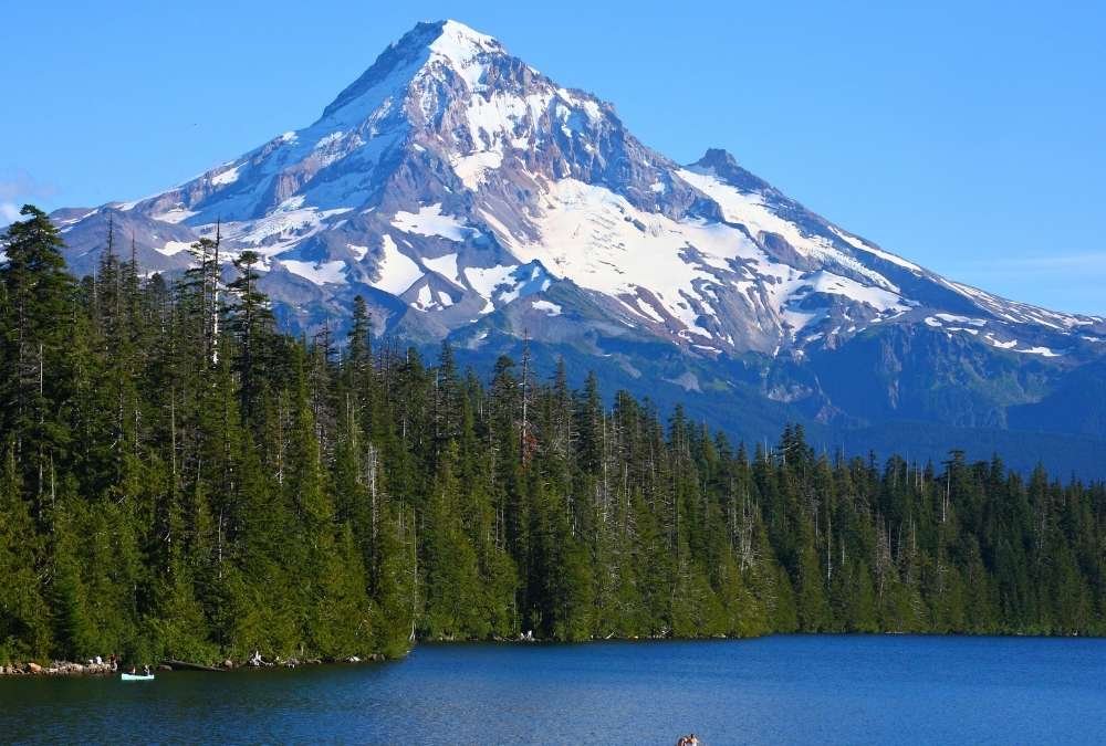
As Oregon’s tallest peak and a year-round adventure spot, Mount Hood offers one of the best volcano hikes in the U.S. While the summit climb is technical, the Timberline Trail is a perfect way to explore its beauty without needing mountaineering skills.
This 41-mile loop (or shorter sections) takes you around the entire mountain, crossing glacial rivers, alpine meadows, and old-growth forests. If you’re short on time, the Paradise Park Trail is a great alternative—a 12-mile out-and-back hike that rewards you with some of the best wildflower meadows and views of Hood’s glacier-covered peak.
Mount Hood is also home to the historic Timberline Lodge, a great post-hike stop for a meal or even an overnight stay. Whether you’re hiking for a day or taking on the full loop, Mount Hood delivers an epic mountain experience without the extreme difficulty of some other Cascade volcanoes.
- Best Months to Visit: July – October
- Difficulty Level: Moderate to Strenuous (Depends on the route)
- Permit Required? Some areas require wilderness permits
- Trail Length & Time: Varies, ~6-12 miles for best scenic hikes
- Highlight: Diverse landscapes and breathtaking alpine scenery
6. South Sister, Oregon
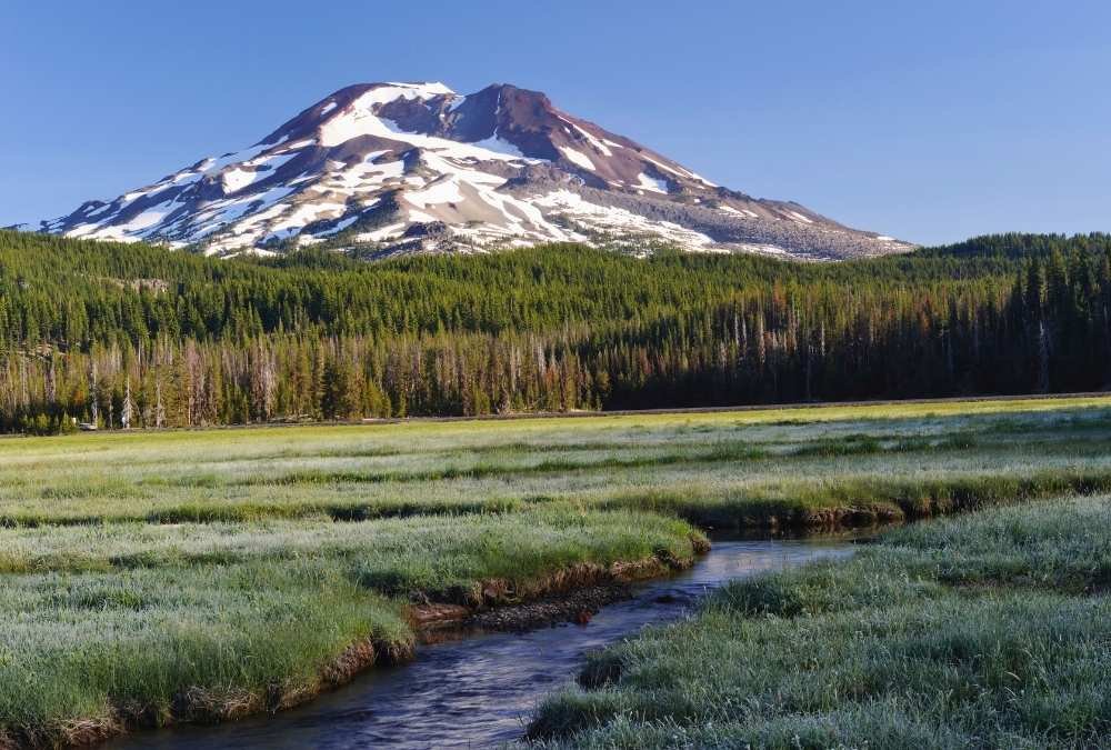
If you’re craving a challenging yet rewarding climb, South Sister delivers. As the third tallest peak in Oregon at 10,358 feet, this volcano offers one of the most accessible big mountain experiences in the Pacific Northwest. Unlike technical summits that require ropes and ice axes, South Sister is a hikeable volcano, meaning determined hikers can make it to the top with just stamina and perseverance.
The Devil’s Lake Trailhead is where most adventurers start their ascent. The first section winds through lush subalpine forests, but soon, the trail reveals its true nature—a relentless grind up steep, loose volcanic scree. The reward for this grueling effort? A breathtaking 360-degree panorama at the summit, with a striking turquoise glacial lake nestled in the crater. On a clear day, you’ll see as far as Mount Hood, Mount Jefferson, and the Cascade Range stretching endlessly before you.
Hiking South Sister is a test of endurance, but it’s also an incredibly rewarding experience. Every step is a reminder that nature rewards those who push their limits, and the euphoric feeling at the summit makes the burning legs and tired lungs completely worth it.
- Best Months to Visit: July – September (Snow-free and best trail conditions)
- Difficulty Level: Very Strenuous (Steep, loose rock, and high elevation)
- Permit Required? Yes, a wilderness permit required
- Trail Length & Time: 12 miles round trip, ~8-12 hours
- Highlight: Crater lake at the summit and jaw-dropping Cascade views
7. Mount Shasta, California

Some mountains demand respect, and Mount Shasta is one of them. Towering at 14,179 feet, this massive stratovolcano is a beacon in Northern California, calling to adventurers who want to experience its rugged beauty. While the summit requires mountaineering skills, there are plenty of incredible hikes that let you soak in Shasta’s grandeur without climbing into thin air.
For a more accessible adventure, the Panther Meadows Trail is a fantastic option. This moderate hike winds through alpine meadows dotted with wildflowers and natural springs, offering unbeatable views of the snow-capped peak above. Another great option is the Avalanche Gulch Trail, which provides a closer look at the mountain’s glaciers and volcanic rock formations.
Shasta is more than just a volcano—it’s a spiritual place, often described as having a mystical energy. Whether you believe in its legendary status or just want to revel in the sheer beauty of nature, hiking here is an experience you won’t forget.
- Best Months to Visit: June – September (Best hiking conditions)
- Difficulty Level: Moderate to Strenuous (Depends on the trail)
- Permit Required? Yes, permits needed for wilderness hikes
- Trail Length & Time: Varies, ~3-10 miles depending on the route
- Highlight: Majestic mountain views and high-altitude alpine landscapes
8. Capulin Volcano, New Mexico
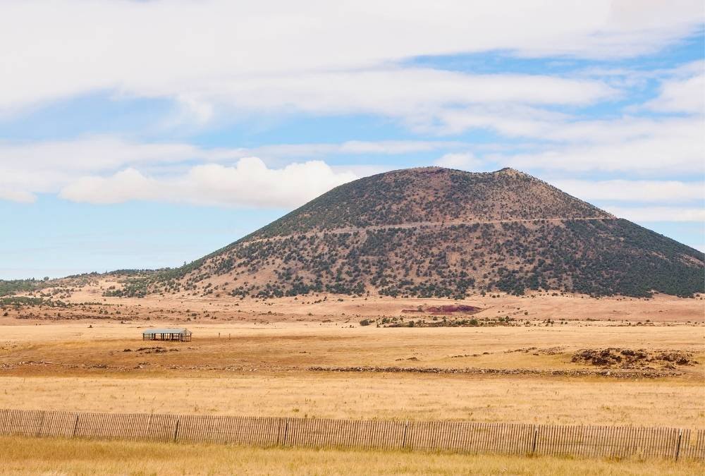
Want a volcano hike that’s short, easy, and unique? Capulin Volcano is your spot. Unlike the towering, snow-covered peaks of the Cascades, Capulin is a cinder cone volcano, meaning it’s relatively small and perfect for a quick yet memorable hike.
The Crater Rim Trail is just 1 mile, but don’t let the short distance fool you—this paved trail offers jaw-dropping panoramic views of the surrounding New Mexico plains and volcanic fields. You can even take a detour into the volcano’s crater, a rare experience that lets you stand inside an extinct eruption site.
Capulin is a great choice for families or those who want to experience a volcano without a grueling trek. Plus, it’s a fantastic geological history lesson, with visitor center exhibits explaining how this area was once a hotbed of volcanic activity.
- Best Months to Visit: Year-round, but spring and fall offer cooler temps
- Difficulty Level: Easy (Paved trail, minimal elevation gain)
- Permit Required? No
- Trail Length & Time: 1-mile round trip, ~30-45 minutes
- Highlight: Walking inside a crater and panoramic desert views
9. Sunset Crater, Arizona
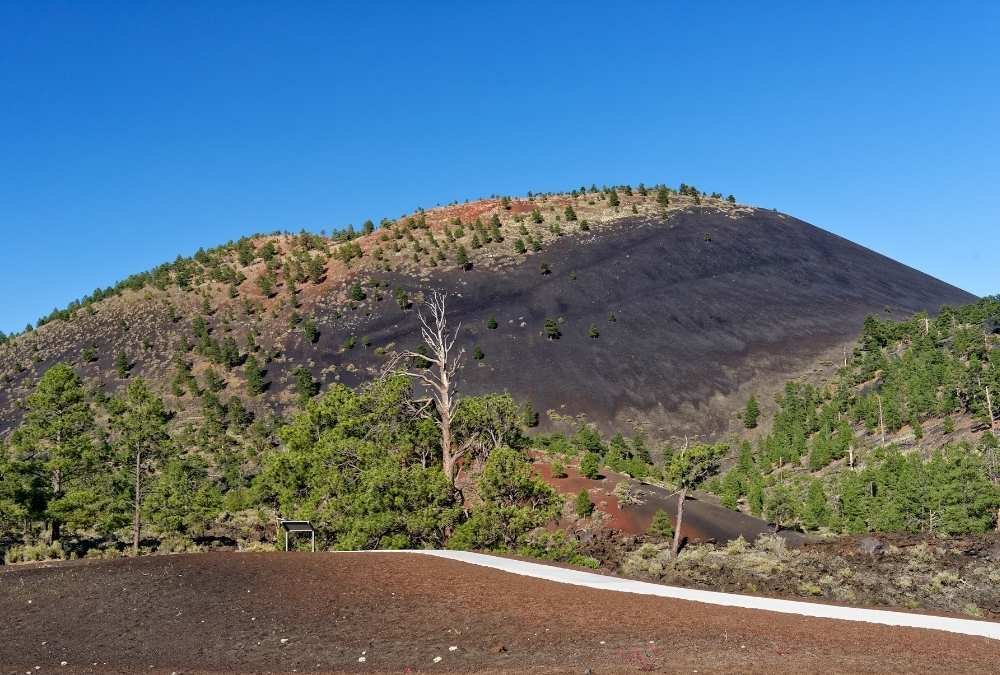
Something is mesmerizing about a landscape that looks frozen in time, and Sunset Crater delivers just that. Located near Flagstaff, Arizona, this volcano last erupted just 1,000 years ago, meaning its lava flows are still stark, black, and eerily fresh compared to ancient, eroded peaks.
The Lava Flow Trail is the best way to experience this surreal landscape. This 1-mile loop winds through jagged lava fields, scorched earth, and sparse pine forests, offering a glimpse into Arizona’s volcanic past. While you can’t hike to the actual crater summit (due to preservation efforts), the nearby Lenox Crater Trail provides a moderate climb with sweeping views of the volcanic field.
Sunset Crater is a fantastic detour for road-trippers exploring Arizona’s high desert. It’s short, fascinating, and completely different from the state’s iconic red rock landscapes, making it a great stop before heading to the Grand Canyon or Sedona.
- Best Months to Visit: Spring and Fall (Avoid extreme summer heat)
- Difficulty Level: Easy to Moderate
- Permit Required? No, but an entry fee required for the national monument
- Trail Length & Time: 1-2 miles, ~30-60 minutes
- Highlight: Lava fields and unique volcanic terrain in Arizona’s desert
10. Craters of the Moon, Idaho
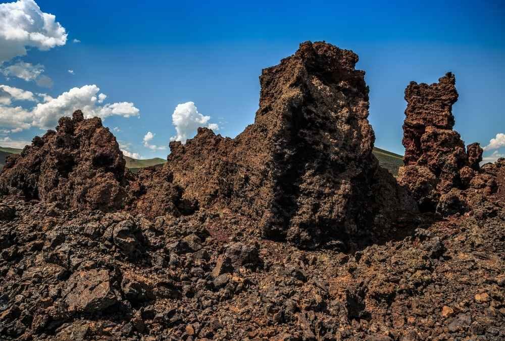
Step onto the trails at Craters of the Moon, and you might think you’ve landed on another planet. This vast, eerie landscape of hardened lava, craters, and cinder cones covers more than 750,000 acres in southern Idaho, offering one of the most alien-like hiking experiences in the U.S.
The Inferno Cone Trail is a short but steep hike that takes you to the top of a black volcanic cone, offering otherworldly views of the lava fields stretching into the horizon. If you’re up for a longer adventure, the North Crater Trail lets you explore lava tubes and bizarre rock formations that look like they belong on Mars.
Craters of the Moon is one of the most underrated volcanic parks in the country. It’s remote, quiet, and stunningly unique. Whether you’re into geology, or photography, or just want to experience something completely different, this hike is worth adding to your list.
- Best Months to Visit: Spring and Fall (Summers are brutally hot)
- Difficulty Level: Easy to Moderate (Short hikes, but some steep terrain)
- Permit Required? No
- Trail Length & Time: Varies, ~1-4 miles
- Highlight: Lava tubes, cinder cones, and an out-of-this-world landscape