There’s something magical about discovering a city on foot—not just skimming the surface but feeling its heartbeat, uncovering its hidden corners, and seeing it from breathtaking new angles.
Forget crowded tour buses and rigid itineraries—the real soul of a city reveals itself when you lace up your shoes and explore. From rugged coastal cliffs to secret staircases and lush green escapes, urban hikes offer a rare mix of adventure and connection.
You don’t have to leave the city to find breathtaking views, unexpected serenity, or a little adrenaline rush. Ready to see the world’s most exciting cities like never before? Let’s go.
1. Manhattan Waterfront Greenway – New York City, USA

New York City may be known for its towering skyscrapers and bustling streets, but the Manhattan Waterfront Greenway offers a completely different side of the city—one that’s serene, scenic, and perfect for urban hiking. Spanning 32 miles, this incredible trail encircles Manhattan, offering stunning views of the Hudson River, the East River, and the Statue of Liberty in the distance. Whether you’re an early-morning jogger or a sunset stroller, this trail lets you soak in the city’s most iconic sights at your own pace.
One of the best things about this hike is the sheer variety of landscapes you’ll encounter. The Hudson River Park section feels like a nature escape, complete with waterfront seating and lush greenery, while the East River Esplanade offers a fascinating glimpse into New York’s maritime history. The stretch around Battery Park is a personal favorite—it’s where the city meets the water in the most cinematic way possible. You can stop for a coffee, people-watch, or simply enjoy the skyline reflecting off the waves.
For those who love blending city walks with cultural pit stops, this trail is a dream. Along the way, you’ll pass landmarks like Chelsea Piers, the Brooklyn Bridge, and Riverside Park. Whether you’re a tourist looking to experience NYC beyond Times Square or a local rediscovering your city, this hike captures the heart and soul of New York in the best way possible—on foot.
Quick Trail Details:
- Best Time to Visit: Spring and Fall (March-May & September-November)
- Length: 32 miles (can be done in shorter sections)
- Difficulty: Easy to moderate (mostly paved)
- Highlights: Hudson River Park, Brooklyn Bridge views, Battery Park
- Nearby Attractions: The High Line, Chelsea Market, South Street Seaport
2. Stanley Park Seawall – Vancouver, Canada

If there’s one urban hike that effortlessly blends city and nature, it’s the Stanley Park Seawall in Vancouver. This 10-kilometer (6.2-mile) loop wraps around Stanley Park, treating you to breathtaking views of the Pacific Ocean, forested trails, and the Vancouver skyline. It’s one of those rare city hikes where you can hear both seagulls and the distant hum of downtown traffic—a perfect balance between urban energy and natural tranquility.
Walking the Seawall is an experience in itself. You’ll pass beaches, dense forests, historic totem poles and even spot sea otters and herons along the way. The path is wide and well-maintained, making it ideal for hikers, bikers, and casual walkers alike. Whether you’re starting at Coal Harbour or English Bay, every step along the Seawall offers postcard-worthy views. My favorite stretch? The section near Siwash Rock—a natural sea stack that looks magical during sunset.
Stanley Park itself is a treasure trove of exploration. If you take detours from the Seawall, you can wander into ancient cedar forests, discover hidden gardens, or even visit the Vancouver Aquarium. It’s the kind of place where one visit is never enough—you’ll keep coming back to uncover something new each time.
Quick Trail Details:
- Best Time to Visit: Year-round, but summer (June-August) offers the best weather
- Length: 6.2 miles (10 km)
- Difficulty: Easy (paved and flat)
- Highlights: Ocean views, beaches, Siwash Rock, Totem Poles
- Nearby Attractions: Vancouver Aquarium, Granville Island, Gastown
3. Arthur’s Seat – Edinburgh, Scotland

Standing tall above Edinburgh’s medieval skyline, Arthur’s Seat is the ultimate urban escape—where history, legend, and breathtaking views collide. This extinct volcano sits in Holyrood Park, just a short walk from the Royal Mile, but once you’re on the trail, it feels like a world away from the city.
The hike to the summit is steep but rewarding. As you ascend, you’ll pass rugged hills, ancient ruins, and grassy knolls that look straight out of a fantasy novel. By the time you reach the top, you’ll be standing at 822 feet, looking down at Edinburgh Castle, the Firth of Forth, and the winding streets of the old city. It’s especially stunning at sunrise or sunset, when the city is bathed in golden light.
Arthur’s Seat isn’t just a great hike—it’s steeped in Scottish folklore. Some say it’s the legendary location of Camelot, while others believe it has mystical healing powers. Whether you believe the myths or not, there’s something undeniably magical about this hike—it’s one of those places where history whispers through the wind.
Quick Trail Details:
- Best Time to Visit: Spring and Summer (April-September)
- Length: 2.4 miles (3.8 km) round trip
- Difficulty: Moderate (steep in parts)
- Highlights: Panoramic views, ancient ruins, Holyrood Palace
- Nearby Attractions: Edinburgh Castle, The Royal Mile, Scottish Parliament
4. Lands End Trail – San Francisco, USA
San Francisco’s Lands End Trail is one of those hikes that makes you forget you’re in a city. This rugged coastal trail offers jaw-dropping views of the Golden Gate Bridge, the Pacific Ocean, and the dramatic cliffs of the Bay Area. It’s the perfect mix of wild and urban—one minute, you’re walking through wind-swept cypress groves, and the next, you’re gazing at shipwreck remnants along the rocky shore.
One of the highlights of this hike is Mile Rock Beach, a small, secluded cove with stone cairns and incredible sunset views. Another must-see spot is the Sutro Baths ruins, a hauntingly beautiful reminder of San Francisco’s past. And, of course, the Golden Gate Bridge lookout—if you want that perfect postcard shot, this is the place.
The best part? It’s an easy hike but feels like an adventure. Whether you’re a local escaping the city for a few hours or a visitor exploring SF’s wilder side, Lands End delivers that perfect blend of nature and history.
Quick Trail Details:
- Best Time to Visit: Spring and Fall (March-May & September-November)
- Length: 3.4 miles (5.5 km) round trip
- Difficulty: Easy to Moderate (some stairs and uneven paths)
- Highlights: Golden Gate Bridge views, Mile Rock Beach, Sutro Baths
- Nearby Attractions: Golden Gate Park, The Presidio, Baker Beach
5. Table Mountain (Platteklip Gorge) – Cape Town, South Africa

Table Mountain isn’t just a hike—it’s an icon. Towering over Cape Town at 3,558 feet (1,084 meters), this flat-topped wonder offers some of the best city views in the world. While there are multiple routes to the top, Platteklip Gorge is the most direct (and popular) trail.
This hike is a workout. It’s steep, rocky, and full of switchbacks, but the sense of accomplishment when you reach the top is unbeatable. Once there, you can walk along the plateau, spot dassies (rock hyraxes), and take in panoramic views of the city, Robben Island, and the vast Atlantic Ocean. If you don’t want to hike back down, the cable car ride is a great way to enjoy the views without the effort.
Table Mountain is a must for anyone visiting Cape Town. It’s a hike that leaves you breathless—both from the climb and the view.
Quick Trail Details:
- Best Time to Visit: Summer and Fall (November-April)
- Length: 1.8 miles (2.9 km) one way
- Difficulty: Hard (steep and strenuous)
- Highlights: 360° views, unique flora, cable car descent
- Nearby Attractions: Cape Point, Camps Bay Beach, V&A Waterfront
6. Hollywood Hills Hike – Los Angeles, USA
Los Angeles may be the city of cars and freeways, but if you want to experience the real magic of LA, you need to hit the trails. The Hollywood Hills Hike offers the perfect blend of city skyline views, rugged landscapes, and, of course, the iconic Hollywood Sign. Whether you’re looking for a heart-pumping workout or a leisurely walk with breathtaking views, this trail delivers.
There are multiple routes to explore, but the Griffith Observatory to Hollywood Sign trail is a fan favorite. The hike takes you through Griffith Park, one of the largest urban parks in the US, offering sweeping views of downtown LA, the Pacific Ocean, and even Catalina Island on a clear day. My favorite part? The moment when the Hollywood Sign finally comes into full view—it’s a surreal experience, no matter how many times you’ve seen it in movies.
This hike isn’t just about getting close to the sign; it’s about seeing Los Angeles from a whole new perspective. The golden California sun, the palm-tree-dotted skyline, and the vast urban sprawl stretching out below—it’s a reminder of why people fall in love with this city.
Quick Trail Details:
- Best Time to Visit: Fall to Spring (October-May, to avoid summer heat)
- Length: 6.4 miles (10.3 km) round trip
- Difficulty: Moderate (some inclines)
- Highlights: Hollywood Sign views, Griffith Observatory, panoramic cityscape
- Nearby Attractions: Griffith Observatory, Sunset Boulevard, Walk of Fame
7. Sydney Harbour Bridge to Manly – Sydney, Australia

If you want to experience Sydney’s iconic beauty on foot, the Sydney Harbour Bridge to Manly hike is a must. This stunning coastal walk takes you from the heart of the city to the laid-back beachside suburb of Manly, passing through lush reserves, historic sites, and breathtaking harbor views.
The adventure starts at Circular Quay, where you’ll cross the Sydney Harbour Bridge for an unbeatable view of the Opera House and skyline. From there, the trail winds through neutral bays, hidden beaches, and the lush greenery of Sydney Harbour National Park. It’s a mix of urban and nature, with glimpses of heritage mansions, Aboriginal rock carvings, and even wild cockatoos along the way.
By the time you reach Manly Beach, you’ll be ready to kick off your shoes and relax by the ocean. The best way to end the hike? Grab a cold drink at one of the beachside cafes before hopping on a ferry back to Circular Quay—arguably one of the best short boat rides in the world.
Quick Trail Details:
- Best Time to Visit: Year-round, but spring (September-November) is best for mild weather
- Length: 10 miles (16 km) one way
- Difficulty: Moderate (some steep sections)
- Highlights: Sydney Harbour Bridge, hidden beaches, Manly Beach
- Nearby Attractions: Sydney Opera House, Taronga Zoo, Darling Harbour
8. The High Line – New York City, USA

New York City’s High Line isn’t just a trail—it’s an experience. This elevated urban park is built on a former railway line, offering a unique blend of city views, greenery, and art installations. Walking along the High Line feels like stepping into a futuristic city where nature and architecture coexist in perfect harmony.
Stretching 1.45 miles through Chelsea and the Meatpacking District, the High Line is one of NYC’s most popular walks. You’ll pass modern skyscrapers, repurposed warehouses, and public art pieces, all while enjoying views of the Hudson River and the bustling streets below. The seasonal gardens lining the walkway make every visit feel fresh—spring brings cherry blossoms, summer explodes with wildflowers, and autumn transforms the trail into a golden wonderland.
While the High Line isn’t a traditional hike, it’s one of the most immersive ways to experience New York on foot. Whether you’re a local looking for a peaceful escape or a visitor soaking in the city’s creative energy, this urban trail is a must-do.
Quick Trail Details:
- Best Time to Visit: Spring and Fall (March-May & September-November)
- Length: 1.45 miles (2.3 km)
- Difficulty: Easy (flat and paved)
- Highlights: Urban gardens, public art, Hudson River views
- Nearby Attractions: Chelsea Market, Whitney Museum, Hudson Yards
9. Mont Royal Park – Montreal, Canada

Montreal’s Mont Royal Park is the perfect city escape, offering a lush green haven right in the heart of the city. Designed by Frederick Law Olmsted (the same landscape architect behind Central Park), this urban hiking trail winds through forests, scenic overlooks, and even a historic chapel, giving you the best of both nature and city views.
The main trail leads to Mont Royal’s summit, where you’ll find the famous Kondiaronk Belvedere—a lookout that offers jaw-dropping views of downtown Montreal, the St. Lawrence River, and beyond. It’s the kind of place where you’ll want to linger, soaking in the view while sipping a coffee from one of the nearby kiosks.
Mont Royal isn’t just for hikers—it’s a year-round playground for outdoor lovers. In winter, you can go snowshoeing or tobogganing, while autumn turns the park into a fiery masterpiece of red and orange leaves. If you’re in Montreal and want to escape the city without leaving it, this is the trail for you.
Quick Trail Details:
- Best Time to Visit: Fall (September-November) for foliage, or Summer (June-August)
- Length: 4.3 miles (7 km) round trip
- Difficulty: Moderate (some inclines)
- Highlights: City views, lush forest, historic landmarks
- Nearby Attractions: Old Montreal, Jean-Talon Market, Notre-Dame Basilica
10. Bukit Timah Nature Reserve – Singapor

Singapore is often thought of as a sleek urban metropolis, but hidden within its modern skyline is a lush rainforest hike unlike any other. The Bukit Timah Nature Reserve offers a chance to escape the city’s high-rises and step into a world of towering trees, exotic wildlife, and challenging trails.
The hike to Bukit Timah Hill, Singapore’s highest natural peak at 163 meters (537 feet), is short but intense. The steep jungle trail is lined with massive trees, wild monkeys, and even the occasional pangolin sighting. Despite being just a 30-minute drive from downtown, it feels like you’ve stepped into a tropical rainforest miles away from civilization.
For such a small country, Singapore packs an incredible amount of biodiversity into this reserve. If you love the idea of hiking through dense jungle while still being within arm’s reach of city life, this trail is a must-visit.
Quick Trail Details:
- Best Time to Visit: Early morning or late afternoon to avoid the heat (Year-round)
- Length: 3.2 miles (5.2 km) round trip
- Difficulty: Moderate (steep incline)
- Highlights: Rainforest setting, exotic wildlife, panoramic city views
- Nearby Attractions: Botanic Gardens, Marina Bay Sands, Chinatown
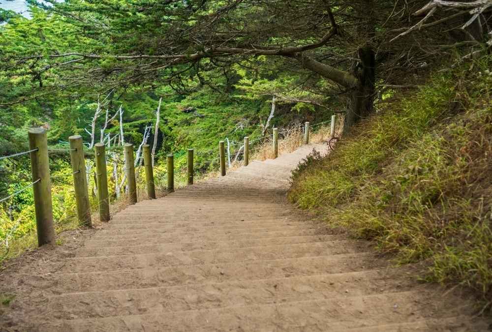
11. Telegraph Hill & Coit Tower Stairs – San Francisco, USA

San Francisco is a city of hills, and few hikes capture its charm as well as the Telegraph Hill & Coit Tower Stairs. This isn’t just a workout for your legs—it’s a stairway to some of the best views in the city. Hidden gardens, quirky houses, and the chance to spot San Francisco’s famous wild parrots make this urban trail feel like a little adventure within the city.
The most scenic way up is via the Filbert Street Steps, which start near the Embarcadero and weave through lush gardens, offering glimpses of Alcatraz and the Bay Bridge. Once at the top, Coit Tower’s panoramic view of the city is well worth the climb. If you still have energy, take the Greenwich Steps down—it’s a quieter route but equally charming.
Unlike San Francisco’s more famous (and crowded) streets, this route feels personal and intimate. Whether you’re a visitor looking for a break from tourist hotspots or a local rediscovering the city, this is one of SF’s most rewarding urban hikes.
Quick Trail Details:
- Best Time to Visit: Year-round, but spring and fall are most pleasant
- Length: About 0.5 miles (but steep!)
- Difficulty: Moderate (lots of stairs)
- Highlights: Coit Tower, wild parrots, secret gardens
- Nearby Attractions: Pier 39, North Beach, Lombard Street
12. Mission Trails Regional Park – San Diego, USA

San Diego is famous for its beaches, but if you’re craving a more rugged, nature-filled adventure within city limits, Mission Trails Regional Park is the place to go. Covering over 8,000 acres, this park offers miles of scenic hiking trails, with the Cowles Mountain Trail being the standout route.
The trail to Cowles Mountain Summit is short but intense—expect steep inclines and rocky paths. The payoff? A sweeping 360-degree view of San Diego, from downtown to the Pacific Ocean. It’s a local favorite for sunrise and sunset hikes, and there’s something special about seeing the city from such a high vantage point.
For those who prefer a less strenuous route, the park has plenty of other scenic trails, including Oak Canyon and the Visitor Center Loop. Whether you’re looking for a full-on workout or a peaceful escape into nature, Mission Trails delivers a perfect balance of city and wilderness.
Quick Trail Details:
- Best Time to Visit: Fall through spring (September-April) to avoid extreme heat
- Length: 3 miles (4.8 km) round trip to Cowles Mountain Summit
- Difficulty: Moderate to Hard (steep incline)
- Highlights: Panoramic city views, rugged landscapes, multiple trail options
- Nearby Attractions: Balboa Park, La Jolla Cove, Gaslamp Quarter
13. Hampstead Heath & Parliament Hill – London, England
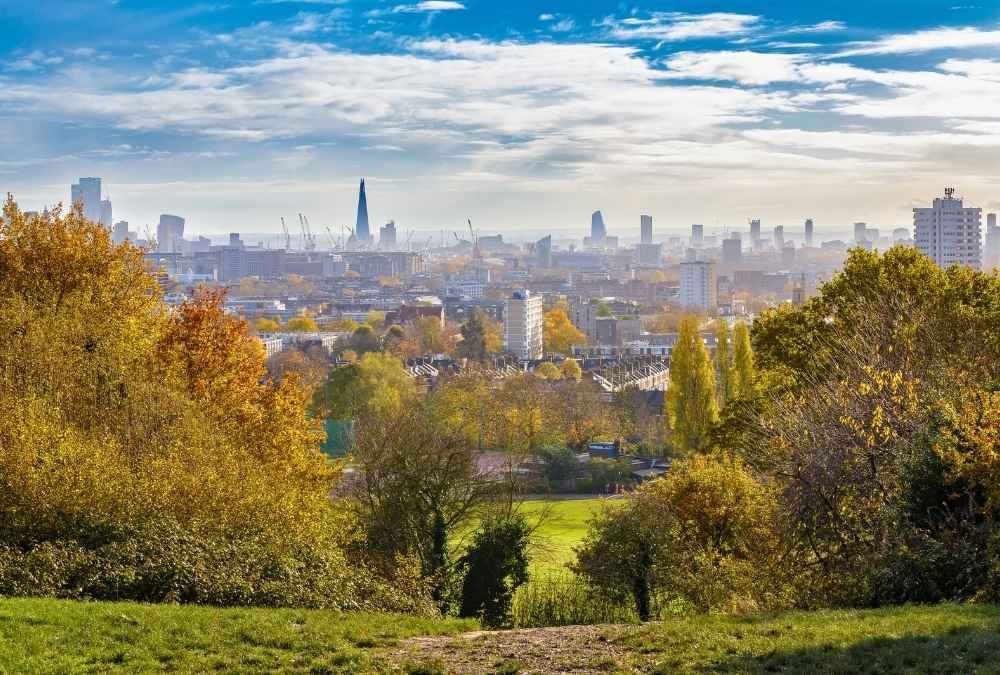
London is one of the world’s most walkable cities, but if you’re craving green space with a spectacular skyline view, Hampstead Heath is the place to be. This sprawling 790-acre park feels a world away from the city’s fast pace—a wild, untamed slice of countryside in the heart of London.
The best hike? The climb up Parliament Hill, where you’re rewarded with one of the most breathtaking views of London’s skyline. You’ll see the Shard, St. Paul’s Cathedral, and even the London Eye in the distance. It’s a favorite spot for locals looking to escape the concrete jungle and breathe in some fresh air.
Beyond Parliament Hill, Hampstead Heath offers a maze of hidden trails, woodlands, ponds, and even a secret pergola. It’s the perfect place for a lazy afternoon stroll, a morning workout, or a quiet moment with nature. If you visit in summer, bring a swimsuit—the Heath’s swimming ponds are legendary.
Quick Trail Details:
- Best Time to Visit: Year-round, but autumn is especially beautiful
- Length: 3-5 miles, depending on route
- Difficulty: Easy to Moderate (some gentle inclines)
- Highlights: London skyline views, wild nature, swimming ponds
- Nearby Attractions: Camden Market, British Museum, Regent’s Park
14. The 606 Trail – Chicago, USA

Chicago’s The 606 is proof that an urban hike can be both scenic and stylish. Built on an abandoned railway line, this elevated 2.7-mile trail stretches across multiple neighborhoods, offering a unique blend of art, history, and nature.
As you walk, bike, or jog along the trail, you’ll pass through Wicker Park, Bucktown, and Humboldt Park, each with its distinct vibe. Expect to see public art installations, graffiti murals, and a mix of old industrial buildings and trendy cafés. Unlike typical nature hikes, this one is full of urban energy—but that’s part of its charm.
The 606 is a great way to explore Chicago beyond the touristy spots. Whether you’re into people-watching, discovering new coffee shops, or simply looking for a relaxing city walk with a creative edge, this trail is a must.
Quick Trail Details:
- Best Time to Visit: Spring through fall (March-October)
- Length: 2.7 miles (4.3 km)
- Difficulty: Easy (flat and paved)
- Highlights: Street art, skyline views, vibrant neighborhoods
- Nearby Attractions: Millennium Park, Navy Pier, Magnificent Mile
15. Mount Victoria Lookout Walk – Wellington, New Zealand

Last but not least, Mount Victoria Lookout Walk is one of Wellington’s best-kept secrets. This short yet rewarding hike offers panoramic views of the entire city, the harbor, and even the distant mountain ranges.
The climb begins in Courtenay Place, where the urban streets quickly give way to lush greenery and winding forest trails. As you ascend, you’ll feel like you’re stepping out of the city and into a tranquil natural retreat. By the time you reach the 196-meter summit, you’ll understand why this is one of the most beloved hikes in New Zealand’s capital.
One of the coolest things about this trail? It was a filming location for “The Lord of the Rings”, so movie fans will get a kick out of recognizing the scenery. Plus, the wind at the top is often fierce, but that only adds to the thrill of standing high above the city. If you’re visiting Wellington, make sure this hike is on your list.
Quick Trail Details:
- Best Time to Visit: Spring and summer (October-March) for the best views
- Length: 1.2 miles (2 km) one way
- Difficulty: Moderate (steep incline)
- Highlights: 360-degree city views, LOTR filming locations, scenic forests
- Nearby Attractions: Te Papa Museum, Cuba Street, Wellington Waterfront